TopoQuest Logo
Do you find TopoQuest useful?
Help keep TopoQuest running and adding new maps/features by donating!
Bitcoin:  19c7KJd3qBynnjoSw5npx9KScwjBe4ifkT
Litecoin:  LXs6TkuXGGXo1vDsWCkWVdjQX94eUKd6ui
Home View Maps Find Maps Find Places Resources & Links


Devine, Texas Topographic Map

USGS Map Title: Devine, TX
USGS Map MRC: 29098B8
DRG (GeoTIFF) Download: o29098b8.tif


Neighboring USGS Topographic Map Quads:


  Murphy School, TX  
29099C1
 

  Castroville, TX  
29098C8
 

  La Coste, TX  
29098C7
 

  Biry, TX  
29099B1
 

  Devine, TX  
29098B8
 

  Lytle, TX  
29098B7
 

  Moore, TX  
29099A1
 

  Ghost Hill, TX  
29098A8
 

  Bigfoot, TX  
29098A7


Map MRC Location:

N30°
W99°
N30°
W98°
H8 H7 H6 H5 H4 H3 H2 H1
G8 G7 G6 G5 G4 G3 G2 G1
F8 F7 F6 F5 F4 F3 F2 F1
E8 E7 E6 E5 E4 E3 E2 E1
D8 D7 D6 D5 D4 D3 D2 D1
C8 C7 C6 C5 C4 C3 C2 C1
B8 B7 B6 B5 B4 B3 B2 B1
A8 A7 A6 A5 A4 A3 A2 A1
N29°
W99°
N29°
W98°

Devine, TX USGS 1:24K Topographic Map Preview:
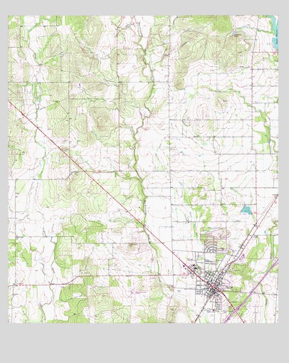
Devine, TX USGS Topographic Map
Click on map above to begin viewing in our Map Viewer.

This topographic map contains these locations and features:
Feature Name Type Latitude Longitude GNIS ID View Map
Betania Baptist Mission ChurchChurchN29.1361°W98.9000°2023233View Map
Bethel Assembly of God ChurchChurchN29.1411°W98.9050°2023232View Map
Black Creek ChurchChurchN29.1602°W98.9961°1352312View Map
Chacon ReservoirReservoirN29.2418°W98.8759°1354244View Map
Chicon LakeReservoirN29.2350°W98.8752°1857764View Map
Chicon Lake DamDamN29.2352°W98.8753°1857763View Map
City of DevineCivilN29.1456°W98.9049°2410332View Map
Colonial Oaks ParkParkN29.1566°W98.9164°2028519View Map
DevinePopulated PlaceN29.1400°W98.9053°1355983View Map
Devine City HallBuildingN29.1378°W98.9070°2753512View Map
Devine City ParkParkN29.1533°W98.9148°2028496View Map
Devine Emergency Medical ServiceBuildingN29.1523°W98.8911°2656098View Map
Devine High SchoolSchoolN29.1477°W98.9167°2007581View Map
Devine Intermediate SchoolSchoolN29.1469°W98.9139°2007582View Map
Devine Middle SchoolSchoolN29.1450°W98.9173°2007583View Map
Devine Municipal AirportAirportN29.1384°W98.9419°1386552View Map
Devine Opera HouseBuildingN29.1383°W98.9059°2031340View Map
Devine Police DepartmentBuildingN29.1378°W98.9069°2750284View Map
Devine Post OfficePost OfficeN29.1395°W98.9073°2731777View Map
Devine Volunteer Fire DepartmentBuildingN29.1375°W98.9063°2551867View Map
Devine-Natalia DivisionCivilN29.1846°W98.9316°1938684View Map
Evergreen CemeteryCemeteryN29.1544°W98.8984°1357115View Map
John J Ciavarra Elementary SchoolSchoolN29.1472°W98.9159°2007586View Map
Jungman LakeReservoirN29.2431°W98.8959°1360469View Map
KTXX-FM (Devine)TowerN29.1330°W98.9864°1385841View Map
Medina County Constable's Office Precinct 4BuildingN29.1385°W98.9066°2750625View Map
Medina Lake State Fish HatcheryLocaleN29.1714°W98.8903°1384617View Map
Primitive ChurchChurchN29.1366°W98.9978°1365789View Map
Roberson CemeteryCemeteryN29.1669°W98.9959°1366573View Map
Rose Hill Church of ChristChurchN29.1502°W98.9095°2023237View Map
Saint Josephs CemeteryCemeteryN29.1544°W98.8995°1367214View Map

Note: Coordinates in the location and feature list above are referenced to NAD83 datum.


Copyright (C) 2008-2025 Ryan Niemi / Sunset Dynamics ... All Rights Reserved