TopoQuest Logo
Do you find TopoQuest useful?
Help keep TopoQuest running and adding new maps/features by donating!
Bitcoin:  19c7KJd3qBynnjoSw5npx9KScwjBe4ifkT
Litecoin:  LXs6TkuXGGXo1vDsWCkWVdjQX94eUKd6ui
Home View Maps Find Maps Find Places Resources & Links


Bigfoot, Texas Topographic Map

USGS Map Title: Bigfoot, TX
USGS Map MRC: 29098A7
DRG (GeoTIFF) Download: o29098a7.tif


Neighboring USGS Topographic Map Quads:


  Devine, TX  
29098B8
 

  Lytle, TX  
29098B7
 

  Somerset, TX  
29098B6
 

  Ghost Hill, TX  
29098A8
 

  Bigfoot, TX  
29098A7
 

  Rossville, TX  
29098A6
 

  Schattel NW, TX  
28098H8
 

  Schattel, TX  
28098H7
 

  Dobrowolski, TX  
28098H6


Map MRC Location:

N30°
W99°
N30°
W98°
H8 H7 H6 H5 H4 H3 H2 H1
G8 G7 G6 G5 G4 G3 G2 G1
F8 F7 F6 F5 F4 F3 F2 F1
E8 E7 E6 E5 E4 E3 E2 E1
D8 D7 D6 D5 D4 D3 D2 D1
C8 C7 C6 C5 C4 C3 C2 C1
B8 B7 B6 B5 B4 B3 B2 B1
A8 A7 A6 A5 A4 A3 A2 A1
N29°
W99°
N29°
W98°

Bigfoot, TX USGS 1:24K Topographic Map Preview:
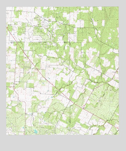
Bigfoot, TX USGS Topographic Map
Click on map above to begin viewing in our Map Viewer.

This topographic map contains these locations and features:
Feature Name Type Latitude Longitude GNIS ID View Map
Bear CreekStreamN29.0758°W98.8164°1351670View Map
Bear Creek Oil FieldOilfieldN29.1097°W98.8356°1351687View Map
Big Foot ColoniaPopulated PlaceN29.0533°W98.8664°2009980View Map
Big Foot Wallace MuseumBuildingN29.0544°W98.8570°2032362View Map
BigfootPopulated PlaceN29.0469°W98.8667°1352186View Map
Bigfoot Census Designated PlaceCensusN29.0618°W98.8521°2407846View Map
Bigfoot Post OfficePost OfficeN29.0488°W98.8667°2732087View Map
Brummett CemeteryCemeteryN29.0714°W98.8122°1353012View Map
Elm CreekStreamN29.0522°W98.7803°1356944View Map
Griffin CemeteryCemeteryN29.1144°W98.8186°1358433View Map
KyotePopulated PlaceN29.0266°W98.7900°1380044View Map
Live Oak CreekStreamN29.0600°W98.7850°1361530View Map
Post Oak CreekStreamN29.0486°W98.7611°1365644View Map
Ranch-Aero AirportAirportN29.0614°W98.8003°1386246View Map
Sand BranchStreamN29.0522°W98.7686°1367566View Map
Sand Branch ChurchChurchN29.0611°W98.7542°1367574View Map
Siestedero Branch CreekStreamN29.0744°W98.8081°1376118View Map
Smith BranchStreamN29.0764°W98.8350°1368455View Map
Vincent LakeReservoirN29.0019°W98.8436°1857620View Map
Vincent Lake DamDamN29.0019°W98.8436°1857619View Map

Note: Coordinates in the location and feature list above are referenced to NAD83 datum.


Copyright (C) 2008-2025 Ryan Niemi / Sunset Dynamics ... All Rights Reserved