TopoQuest Logo
Do you find TopoQuest useful?
Help keep TopoQuest running and adding new maps/features by donating!
Bitcoin:  19c7KJd3qBynnjoSw5npx9KScwjBe4ifkT
Litecoin:  LXs6TkuXGGXo1vDsWCkWVdjQX94eUKd6ui
Home View Maps Find Maps Find Places Resources & Links


Dickeyville, Wisconsin Topographic Map

USGS Map Title: Dickeyville, WI
USGS Map MRC: 42090F5
DRG (GeoTIFF) Download: o42090f5.tif


Neighboring USGS Topographic Map Quads:


  Lancaster, WI  
42090G6
 

  Ellenboro, WI  
42090G5
 

  Rewey, WI  
42090G4
 

  Potosi, WI  
42090F6
 

  Dickeyville, WI  
42090F5
 

  Platteville, WI  
42090F4
 

  Dubuque North, IA  
42090E6
 

  Kieler, WI  
42090E5
 

  Cuba City, WI  
42090E4


Map MRC Location:

N43°
W91°
N43°
W90°
H8 H7 H6 H5 H4 H3 H2 H1
G8 G7 G6 G5 G4 G3 G2 G1
F8 F7 F6 F5 F4 F3 F2 F1
E8 E7 E6 E5 E4 E3 E2 E1
D8 D7 D6 D5 D4 D3 D2 D1
C8 C7 C6 C5 C4 C3 C2 C1
B8 B7 B6 B5 B4 B3 B2 B1
A8 A7 A6 A5 A4 A3 A2 A1
N42°
W91°
N42°
W90°

Dickeyville, WI USGS 1:24K Topographic Map Preview:
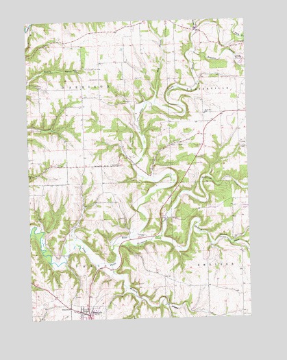
Dickeyville, WI USGS Topographic Map
Click on map above to begin viewing in our Map Viewer.

This topographic map contains these locations and features:
Feature Name Type Latitude Longitude GNIS ID View Map
Blockhouse CreekStreamN42.6558°W90.5776°1561923View Map
Brogley FarmsLocaleN42.7469°W90.6208°2709088View Map
Center SchoolSchoolN42.7300°W90.5954°1562888View Map
CorneliaPopulated PlaceN42.6894°W90.5776°1563403View Map
DickeyvillePopulated PlaceN42.6272°W90.5921°1563972View Map
Dickeyville Elementary SchoolSchoolN42.6303°W90.6026°1563973View Map
Dickeyville Police DepartmentBuildingN42.6291°W90.5886°2759771View Map
French CreekStreamN42.6572°W90.5118°1565306View Map
Grimes FarmLocaleN42.6878°W90.5358°2709092View Map
Harrison CemeteryCemeteryN42.7258°W90.5832°1566090View Map
Holy Ghost Immaculate Conception SchoolSchoolN42.6275°W90.5955°2715796View Map
Kaump CemeteryCemeteryN42.7258°W90.5623°1567365View Map
Little Grant MineMineN42.6900°W90.5482°1568266View Map
Maple Glen SchoolSchoolN42.7114°W90.5235°1568969View Map
McAdam BranchStreamN42.6483°W90.5790°1569157View Map
Mount Zion ChurchChurchN42.6897°W90.5829°1569867View Map
Piddington CemeteryCemeteryN42.6597°W90.5618°1571343View Map
Platte Road BridgeBridgeN42.7492°W90.6221°1840520View Map
Platteville Wastewater Treatment FacilityLocaleN42.7336°W90.5050°2709261View Map
R and R FarmsLocaleN42.7317°W90.5567°2709086View Map
Rountree BranchStreamN42.7367°W90.5287°1582537View Map
Saddleback FarmsLocaleN42.7458°W90.5339°2709094View Map
Snowden BranchStreamN42.6592°W90.5515°1574350View Map
Town of HarrisonCivilN42.7256°W90.6033°1583355View Map
Town of ParisCivilN42.6387°W90.6033°1583893View Map
Vannatta FarmsLocaleN42.6333°W90.5306°2709229View Map
Village of DickeyvilleCivilN42.6251°W90.5913°1583085View Map
Whig BranchStreamN42.7153°W90.5518°1576606View Map
Young BranchStreamN42.7464°W90.5271°1577115View Map

Note: Coordinates in the location and feature list above are referenced to NAD83 datum.


Copyright (C) 2008-2024 Ryan Niemi / Sunset Dynamics ... All Rights Reserved