TopoQuest Logo
Do you find TopoQuest useful?
Help keep TopoQuest running and adding new maps/features by donating!
Bitcoin:  19c7KJd3qBynnjoSw5npx9KScwjBe4ifkT
Litecoin:  LXs6TkuXGGXo1vDsWCkWVdjQX94eUKd6ui
Home View Maps Find Maps Find Places Resources & Links


Doddridge NE, Arkansas Topographic Map

USGS Map Title: Doddridge NE, AR
USGS Map MRC: 33093B7
DRG (GeoTIFF) Download: o33093b7.tif


Neighboring USGS Topographic Map Quads:


  Fouke, AR  
33093C8
 

  Fouke SE, AR  
33093C7
 

  Garland, AR  
33093C6
 

  Doddridge NW, AR  
33093B8
 

  Doddridge NE, AR  
33093B7
 

  Canfield, AR  
33093B6
 

  Doddridge, AR  
33093A8
 

  Doddridge SE, AR  
33093A7
 

  Bradley, AR  
33093A6


Map MRC Location:

N34°
W94°
N34°
W93°
H8 H7 H6 H5 H4 H3 H2 H1
G8 G7 G6 G5 G4 G3 G2 G1
F8 F7 F6 F5 F4 F3 F2 F1
E8 E7 E6 E5 E4 E3 E2 E1
D8 D7 D6 D5 D4 D3 D2 D1
C8 C7 C6 C5 C4 C3 C2 C1
B8 B7 B6 B5 B4 B3 B2 B1
A8 A7 A6 A5 A4 A3 A2 A1
N33°
W94°
N33°
W93°

Doddridge NE, AR USGS 1:24K Topographic Map Preview:
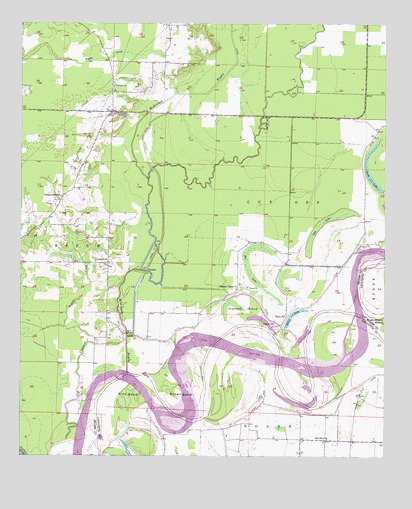
Doddridge NE, AR USGS Topographic Map
Click on map above to begin viewing in our Map Viewer.

This topographic map contains these locations and features:
Feature Name Type Latitude Longitude GNIS ID View Map
Bee LakeSwampN33.1764°W93.7953°46305View Map
Beloh BridgeBridgeN33.1607°W93.8382°46377View Map
Brown BendBendN33.1421°W93.8188°46986View Map
Corinth ChurchChurchN33.1824°W93.8488°48044View Map
FairlandPopulated PlaceN33.2307°W93.8438°63086View Map
Fairland ChurchChurchN33.2321°W93.8430°48960View Map
Goose LakeLakeN33.2044°W93.7543°74852View Map
Haley ChurchChurchN33.1660°W93.7843°49767View Map
Haley LakeLakeN33.1651°W93.7825°74874View Map
Hunters IslandFlatN33.1676°W93.7982°50420View Map
Independence ChurchChurchN33.2004°W93.8610°50487View Map
McKinney BayouStreamN33.1493°W93.8382°51859View Map
Oak LakeSwampN33.1919°W93.7728°52937View Map
Pleasant Valley ChurchChurchN33.1735°W93.8005°53609View Map
Prairie CreekStreamN33.1590°W93.8380°53763View Map
Red River ChurchChurchN33.1301°W93.7696°53957View Map
River Bend Volunteer Fire DepartmentBuildingN33.1298°W93.7787°2117029View Map
Slay BendBendN33.1443°W93.8368°54904View Map
Township of Cut OffCivilN33.2275°W93.7617°68862View Map
Valley GinLocaleN33.1632°W93.7871°55875View Map

Note: Coordinates in the location and feature list above are referenced to NAD83 datum.


Copyright (C) 2008-2025 Ryan Niemi / Sunset Dynamics ... All Rights Reserved