TopoQuest Logo
Do you find TopoQuest useful?
Help keep TopoQuest running and adding new maps/features by donating!
Bitcoin:  19c7KJd3qBynnjoSw5npx9KScwjBe4ifkT
Litecoin:  LXs6TkuXGGXo1vDsWCkWVdjQX94eUKd6ui
Home View Maps Find Maps Find Places Resources & Links


Dodge Center, Minnesota Topographic Map

USGS Map Title: Dodge Center, MN
USGS Map MRC: 44092A7
DRG (GeoTIFF) Download: o44092a7.tif


Neighboring USGS Topographic Map Quads:


  West Concord, MN  
44092B8
 

  Concord, MN  
44092B7
 

  Pine Island, MN  
44092B6
 

  Claremont, MN  
44092A8
 

  Dodge Center, MN  
44092A7
 

  Byron, MN  
44092A6
 

  Hayfield NW, MN  
43092H8
 

  Hayfield, MN  
43092H7
 

  Rock Dell, MN  
43092H6


Map MRC Location:

N45°
W93°
N45°
W92°
H8 H7 H6 H5 H4 H3 H2 H1
G8 G7 G6 G5 G4 G3 G2 G1
F8 F7 F6 F5 F4 F3 F2 F1
E8 E7 E6 E5 E4 E3 E2 E1
D8 D7 D6 D5 D4 D3 D2 D1
C8 C7 C6 C5 C4 C3 C2 C1
B8 B7 B6 B5 B4 B3 B2 B1
A8 A7 A6 A5 A4 A3 A2 A1
N44°
W93°
N44°
W92°

Dodge Center, MN USGS 1:24K Topographic Map Preview:
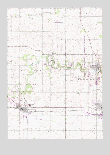
Dodge Center, MN USGS Topographic Map
Click on map above to begin viewing in our Map Viewer.

This topographic map contains these locations and features:
Feature Name Type Latitude Longitude GNIS ID View Map
Assembly of God ChurchChurchN44.0302°W92.8549°2051871View Map
Bethel Baptist ChurchChurchN44.0269°W92.8574°2051873View Map
City of Dodge CenterCivilN44.0289°W92.8508°2394540View Map
City of MantorvilleCivilN44.0656°W92.7537°2395837View Map
Congregational ChurchChurchN44.0280°W92.8546°2051874View Map
Dodge CenterPopulated PlaceN44.0280°W92.8546°642860View Map
Dodge CenterLocaleN44.0275°W92.8552°2051883View Map
Dodge Center AirportAirportN44.0216°W92.8344°660130View Map
Dodge Center Ambulance ServiceBuildingN44.0288°W92.8600°2721247View Map
Dodge Center CreekStreamN44.0794°W92.8266°642861View Map
Dodge Center Fire DepartmentBuildingN44.0327°W92.8526°2051880View Map
Dodge Center LibraryBuildingN44.0286°W92.8557°2051877View Map
Dodge Center Police DepartmentBuildingN44.0279°W92.8553°2051879View Map
Dodge Center Post OfficePost OfficeN44.0280°W92.8557°2051878View Map
Dodge Center Sheriff's OfficeBuildingN44.0683°W92.7545°2051852View Map
Dodge CountyCivilN44.0226°W92.8621°659465View Map
Dodge County CourthouseBuildingN44.0686°W92.7552°2051850View Map
Dodge County Historical Society LibraryBuildingN44.0686°W92.7557°2051844View Map
Fairview Nursing HomeBuildingN44.0305°W92.8263°643521View Map
Faith Lutheran ChurchChurchN44.0302°W92.8599°2051870View Map
First Baptist ChurchChurchN44.0333°W92.7532°2051809View Map
First Congregational ChurchChurchN44.0672°W92.7602°2051849View Map
First Presbyterian ChurchChurchN44.0305°W92.7560°2051813View Map
Fryers Mobile Home ParkPopulated PlaceN44.0691°W92.7557°2051846View Map
Grace Lutheran ChurchChurchN44.0319°W92.8544°2051869View Map
Heritage EstatesPopulated PlaceN44.0261°W92.8569°2051881View Map
KassonPopulated PlaceN44.0300°W92.7507°646049View Map
Kasson Mayo Family Practice CenterHospitalN44.0297°W92.7544°2051817View Map
MantorvillePopulated PlaceN44.0691°W92.7557°647454View Map
Mantorville (historical)LocaleN44.0691°W92.7557°2051847View Map
Mantorville City HallBuildingN44.0669°W92.7549°2051843View Map
Mantorville DamDamN44.0633°W92.7519°1776528View Map
Mantorville Fire DepartmentBuildingN44.0665°W92.7544°2666109View Map
Mantorville Intermediate SchoolSchoolN44.0697°W92.7560°2051848View Map
Mantorville Police DepartmentBuildingN44.0686°W92.7552°2051851View Map
Mantorville Post OfficePost OfficeN44.0669°W92.7557°2051842View Map
Mantorville Retaining Walls ParkParkN44.0689°W92.7555°2051892View Map
Maple Grove CemeteryCemeteryN44.0214°W92.7555°647466View Map
Maranatha Adventist SchoolSchoolN44.0361°W92.8705°2051876View Map
Our Savior Evangelical Lutheran ChurchChurchN44.0358°W92.7599°2051815View Map
Our Saviour Evangelical Lutheran ChurchChurchN44.0316°W92.7532°2051808View Map
Pleasant Corners ChurchChurchN44.0080°W92.8007°649548View Map
Praise Fellowship ChurchChurchN44.0225°W92.8552°2051868View Map
Riverside CemeteryCemeteryN44.0394°W92.8599°650111View Map
Saint John's Lutheran ChurchChurchN44.0325°W92.7596°2051814View Map
Saint Johns Catholic ChurchChurchN44.0302°W92.8532°2051866View Map
Schletty State Wildlife Management AreaParkN44.1122°W92.8113°2051884View Map
Seventh Day Adventist ChurchChurchN44.0361°W92.8705°2051867View Map
South Fork HomesPopulated PlaceN44.0300°W92.7507°2051822View Map
The Church of Jesus Christ of Latter Day SaintsChurchN44.0322°W92.8563°2051872View Map
Township of WasiojaCivilN44.0677°W92.8625°665925View Map
Triton High SchoolSchoolN44.0327°W92.8655°2051875View Map
United Methodist ChurchChurchN44.0366°W92.7549°2051812View Map
Valley View ParkPopulated PlaceN44.0333°W92.8585°2051882View Map
Walter and Ester Stussy Memorial RV ParkLocaleN44.0691°W92.7557°2051845View Map
WasiojaPopulated PlaceN44.0802°W92.8194°653827View Map
Wasioja (historical)LocaleN44.0802°W92.8194°2051784View Map
Wasioja Post Office (historical)Post OfficeN44.0802°W92.8194°2051785View Map
Wasioja Seminary Historical MarkerParkN44.0791°W92.8169°2051893View Map
Wildwood CemeteryCemeteryN44.0713°W92.8144°654145View Map
Windsor Court Mobile Home CommunityPopulated PlaceN44.0208°W92.7516°2051821View Map
Zumbro River ReservoirReservoirN44.0633°W92.7519°1776529View Map

Note: Coordinates in the location and feature list above are referenced to NAD83 datum.


Copyright (C) 2008-2024 Ryan Niemi / Sunset Dynamics ... All Rights Reserved