TopoQuest Logo
Do you find TopoQuest useful?
Help keep TopoQuest running and adding new maps/features by donating!
Bitcoin:  19c7KJd3qBynnjoSw5npx9KScwjBe4ifkT
Litecoin:  LXs6TkuXGGXo1vDsWCkWVdjQX94eUKd6ui
Home View Maps Find Maps Find Places Resources & Links


Claremont, Minnesota Topographic Map

USGS Map Title: Claremont, MN
USGS Map MRC: 44092A8
DRG (GeoTIFF) Download: o44092a8.tif


Neighboring USGS Topographic Map Quads:


  Moland, MN  
44093B1
 

  West Concord, MN  
44092B8
 

  Concord, MN  
44092B7
 

  Owatonna SE, MN  
44093A1
 

  Claremont, MN  
44092A8
 

  Dodge Center, MN  
44092A7
 

  Bixby, MN  
43093H1
 

  Hayfield NW, MN  
43092H8
 

  Hayfield, MN  
43092H7


Map MRC Location:

N45°
W93°
N45°
W92°
H8 H7 H6 H5 H4 H3 H2 H1
G8 G7 G6 G5 G4 G3 G2 G1
F8 F7 F6 F5 F4 F3 F2 F1
E8 E7 E6 E5 E4 E3 E2 E1
D8 D7 D6 D5 D4 D3 D2 D1
C8 C7 C6 C5 C4 C3 C2 C1
B8 B7 B6 B5 B4 B3 B2 B1
A8 A7 A6 A5 A4 A3 A2 A1
N44°
W93°
N44°
W92°

Claremont, MN USGS 1:24K Topographic Map Preview:
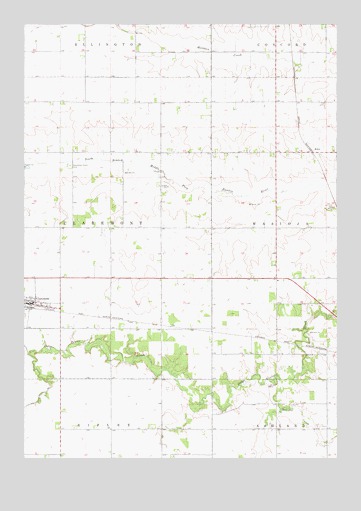
Claremont, MN USGS Topographic Map
Click on map above to begin viewing in our Map Viewer.

This topographic map contains these locations and features:
Feature Name Type Latitude Longitude GNIS ID View Map
Ashland-Ripley CemeteryCemeteryN44.0222°W92.9260°2051895View Map
City of ClaremontCivilN44.0449°W92.9976°2393531View Map
ClaremontPopulated PlaceN44.0444°W92.9977°641239View Map
ClaremontLocaleN44.0436°W92.9985°2051885View Map
Claremont City HallBuildingN44.0441°W92.9963°2051890View Map
Claremont Fire DepartmentBuildingN44.0441°W92.9994°2051891View Map
Claremont Mobile HomesPopulated PlaceN44.0466°W92.9955°2051886View Map
Claremont Post OfficePost OfficeN44.0444°W92.9977°2051887View Map
Claremont Street CemeteryCemeteryN44.0841°W92.9819°641240View Map
EdenPopulated PlaceN44.0880°W92.8849°654685View Map
Henslin CreekStreamN44.0244°W92.8991°644896View Map
Jim Donaldson Pond DamDamN44.0500°W92.8835°1776464View Map
Presbyterian ChurchChurchN44.0452°W92.9955°2051888View Map
Township of ClaremontCivilN44.0670°W92.9851°663805View Map

Note: Coordinates in the location and feature list above are referenced to NAD83 datum.


Copyright (C) 2008-2024 Ryan Niemi / Sunset Dynamics ... All Rights Reserved