TopoQuest Logo
Do you find TopoQuest useful?
Help keep TopoQuest running and adding new maps/features by donating!
Bitcoin:  19c7KJd3qBynnjoSw5npx9KScwjBe4ifkT
Litecoin:  LXs6TkuXGGXo1vDsWCkWVdjQX94eUKd6ui
Home View Maps Find Maps Find Places Resources & Links


Dodson, Louisiana Topographic Map

USGS Map Title: Dodson, LA
USGS Map MRC: 32092A6
DRG (GeoTIFF) Download: o32092a6.tif


Neighboring USGS Topographic Map Quads:


  Danville, LA  
32092B7
 

  Jonesboro South, LA  
32092B6
 

  Weston, LA  
32092B5
 

  Iron Branch, LA  
32092A7
 

  Dodson, LA  
32092A6
 

  Hudson, LA  
32092A5
 

  Calvin, LA  
31092H7
 

  Winnfield West, LA  
31092H6
 

  Winnfield East, LA  
31092H5


Map MRC Location:

N33°
W93°
N33°
W92°
H8 H7 H6 H5 H4 H3 H2 H1
G8 G7 G6 G5 G4 G3 G2 G1
F8 F7 F6 F5 F4 F3 F2 F1
E8 E7 E6 E5 E4 E3 E2 E1
D8 D7 D6 D5 D4 D3 D2 D1
C8 C7 C6 C5 C4 C3 C2 C1
B8 B7 B6 B5 B4 B3 B2 B1
A8 A7 A6 A5 A4 A3 A2 A1
N32°
W93°
N32°
W92°

Dodson, LA USGS 1:24K Topographic Map Preview:
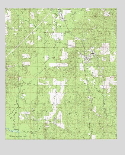
Dodson, LA USGS Topographic Map
Click on map above to begin viewing in our Map Viewer.

This topographic map contains these locations and features:
Feature Name Type Latitude Longitude GNIS ID View Map
Antwine CreekStreamN32.0982°W92.6871°546981View Map
Big CreekStreamN32.0093°W92.7407°547081View Map
Caney CreekStreamN32.0002°W92.7471°553884View Map
Caney CreekStreamN32.0768°W92.7013°553885View Map
Chembond SpurLocaleN32.0399°W92.6549°549126View Map
Cypress CreekStreamN32.0460°W92.7349°547282View Map
DodsonPopulated PlaceN32.0804°W92.6604°554249View Map
Dodson Gas FieldOilfieldN32.0571°W92.6418°549132View Map
DODSON HIGH SCHOOLSchoolN32.0766°W92.6578°549133View Map
Dodson Post OfficePost OfficeN32.0789°W92.6610°1631017View Map
Gansville Gas FieldOilfieldN32.0946°W92.7388°549140View Map
Hargiss SloughGutN32.0035°W92.7335°547439View Map
Hurricane CreekStreamN32.0052°W92.7193°547494View Map
Hurricane Creek ChurchChurchN32.0190°W92.7171°547498View Map
MilamsPopulated PlaceN32.1168°W92.6854°549161View Map
Parish Governing Authority District 10 (historical)CivilN32.0743°W92.6996°1929795View Map
Village of DodsonCivilN32.0808°W92.6587°2407441View Map
Ward FourCivilN32.0960°W92.7465°545290View Map
Ward SevenCivilN32.0632°W92.6254°545293View Map
Winona (historical)Populated PlaceN32.0965°W92.6607°549201View Map
Winona Lookout TowerTowerN32.0293°W92.6549°558841View Map
Zion Hill (historical)Populated PlaceN32.0093°W92.6401°549202View Map
Zion Hill ChurchChurchN32.0099°W92.6421°548168View Map

Note: Coordinates in the location and feature list above are referenced to NAD83 datum.


Copyright (C) 2008-2025 Ryan Niemi / Sunset Dynamics ... All Rights Reserved