TopoQuest Logo
Do you find TopoQuest useful?
Help keep TopoQuest running and adding new maps/features by donating!
Bitcoin:  19c7KJd3qBynnjoSw5npx9KScwjBe4ifkT
Litecoin:  LXs6TkuXGGXo1vDsWCkWVdjQX94eUKd6ui
Home View Maps Find Maps Find Places Resources & Links


Doe Mountain, Washington Topographic Map

USGS Map Title: Doe Mountain, WA
USGS Map MRC: 48120F2
DRG (GeoTIFF) Download: o48120f2.tif


Neighboring USGS Topographic Map Quads:


  Billy Goat Mountain, WA  
48120G3
 

  Mount Barney, WA  
48120G2
 

  Coleman Peak, WA  
48120G1
 

  Sweetgrass Butte, WA  
48120F3
 

  Doe Mountain, WA  
48120F2
 

  Spur Peak, WA  
48120F1
 

  Rendevous Mountain, WA  
48120E3
 

  Lewis Butte, WA  
48120E2
 

  Pearrygin Peak, WA  
48120E1


Map MRC Location:

N49°
W121°
N49°
W120°
H8 H7 H6 H5 H4 H3 H2 H1
G8 G7 G6 G5 G4 G3 G2 G1
F8 F7 F6 F5 F4 F3 F2 F1
E8 E7 E6 E5 E4 E3 E2 E1
D8 D7 D6 D5 D4 D3 D2 D1
C8 C7 C6 C5 C4 C3 C2 C1
B8 B7 B6 B5 B4 B3 B2 B1
A8 A7 A6 A5 A4 A3 A2 A1
N48°
W121°
N48°
W120°

Doe Mountain, WA USGS 1:24K Topographic Map Preview:
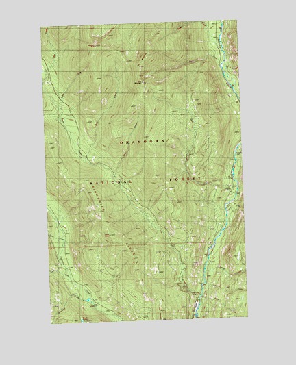
Doe Mountain, WA USGS Topographic Map
Click on map above to begin viewing in our Map Viewer.

This topographic map contains these locations and features:
Feature Name Type Latitude Longitude GNIS ID View Map
Alex CreekStreamN48.6851°W120.2079°1515799View Map
Brevicomis CreekStreamN48.6935°W120.1306°1516935View Map
Buck CreekStreamN48.7318°W120.1356°1517026View Map
Bud CreekStreamN48.6929°W120.2256°1517069View Map
Butte CreekStreamN48.6324°W120.1559°1517157View Map
Camp Four CampgroundLocaleN48.7151°W120.1251°1517280View Map
Chewuch CampgroundLocaleN48.6774°W120.1298°1534576View Map
Deer CreekStreamN48.6443°W120.2381°1518621View Map
Dodd CreekStreamN48.7385°W120.1373°1518825View Map
Doe CreekStreamN48.6760°W120.1309°1518830View Map
Doe MountainSummitN48.7249°W120.1873°1518833View Map
Eightmile RidgeRidgeN48.6715°W120.2181°1519216View Map
Falls CreekStreamN48.6340°W120.1565°1519467View Map
Falls Creek CampgroundLocaleN48.6346°W120.1559°1519468View Map
Falls Creek FallsFallsN48.6368°W120.1624°1529719View Map
Farewell PeakSummitN48.7410°W120.2165°1519477View Map
Ike MountainSummitN48.7315°W120.1887°1521137View Map
Junior CreekStreamN48.6715°W120.1323°1521527View Map
Lamb ButteSummitN48.6615°W120.2118°1521873View Map
Lamb CreekStreamN48.7151°W120.2401°1521875View Map
Leroy CreekStreamN48.6449°W120.1504°1522031View Map
Nice CampgroundLocaleN48.6321°W120.2215°1523646View Map
No Snake CreekStreamN48.7301°W120.1334°1523698View Map
Ortell CreekStreamN48.6596°W120.2412°1524082View Map
Paul MountainSummitN48.6288°W120.1812°1524258View Map
Sherwood CreekStreamN48.6335°W120.2240°1525683View Map
Spring CreekStreamN48.6385°W120.1504°1526415View Map

Note: Coordinates in the location and feature list above are referenced to NAD83 datum.


Copyright (C) 2008-2025 Ryan Niemi / Sunset Dynamics ... All Rights Reserved