TopoQuest Logo
Do you find TopoQuest useful?
Help keep TopoQuest running and adding new maps/features by donating!
Bitcoin:  19c7KJd3qBynnjoSw5npx9KScwjBe4ifkT
Litecoin:  LXs6TkuXGGXo1vDsWCkWVdjQX94eUKd6ui
Home View Maps Find Maps Find Places Resources & Links


Dollar Basin, Oregon Topographic Map

USGS Map Title: Dollar Basin, OR
USGS Map MRC: 44118A5
DRG (GeoTIFF) Download: o44118a5.tif


Neighboring USGS Topographic Map Quads:


  Logan Valley West, OR  
44118B6
 

  Logan Valley East, OR  
44118B5
 

  Crane Prairie, OR  
44118B4
 

  Magpie Table, OR  
44118A6
 

  Dollar Basin, OR  
44118A5
 

  Knox Mountain, OR  
44118A4
 

  Van, OR  
43118H6
 

  Moffit Table, OR  
43118H5
 

  Otis Mountain, OR  
43118H4


Map MRC Location:

N45°
W119°
N45°
W118°
H8 H7 H6 H5 H4 H3 H2 H1
G8 G7 G6 G5 G4 G3 G2 G1
F8 F7 F6 F5 F4 F3 F2 F1
E8 E7 E6 E5 E4 E3 E2 E1
D8 D7 D6 D5 D4 D3 D2 D1
C8 C7 C6 C5 C4 C3 C2 C1
B8 B7 B6 B5 B4 B3 B2 B1
A8 A7 A6 A5 A4 A3 A2 A1
N44°
W119°
N44°
W118°

Dollar Basin, OR USGS 1:24K Topographic Map Preview:
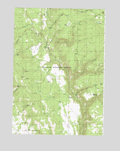
Dollar Basin, OR USGS Topographic Map
Click on map above to begin viewing in our Map Viewer.

This topographic map contains these locations and features:
Feature Name Type Latitude Longitude GNIS ID View Map
Altnow SpringSpringN44.0549°W118.6070°1137181View Map
Black CanyonValleyN44.0838°W118.5766°1138182View Map
Black Canyon CreekStreamN44.0835°W118.5763°1138190View Map
Blinn SpringSpringN44.0207°W118.5796°1138263View Map
Box SpringSpringN44.1216°W118.5021°1138538View Map
Cliff CreekStreamN44.0524°W118.5474°1139824View Map
Cold SpringSpringN44.1192°W118.5595°1139933View Map
Cold Spring CanyonValleyN44.1027°W118.5852°1139956View Map
Diamond Dot GulchValleyN44.1046°W118.6016°1140995View Map
Dollar BasinBasinN44.0810°W118.5952°1141155View Map
Dollar Basin CreekStreamN44.0927°W118.5822°1141156View Map
Dry MeadowFlatN44.1116°W118.5075°1141345View Map
Hawk Spring (historical)SpringN44.0707°W118.5024°1154178View Map
Hog FlatFlatN44.0138°W118.5502°1143641View Map
Hog Flat SpringSpringN44.0325°W118.5587°1143642View Map
Jordan SpringSpringN44.0411°W118.5941°1144400View Map
Lake Camp GulchValleyN44.0885°W118.5802°1144748View Map
Lake Camp SpringSpringN44.1078°W118.5537°1144749View Map
Lee CreekStreamN44.0282°W118.5274°1144909View Map
Little Bear SpringSpringN44.0280°W118.6062°1145093View Map
Malheur FordLocaleN44.0863°W118.5788°1154715View Map
Malheur Ford Camp (historical)LocaleN44.0879°W118.5788°1156761View Map
Malheur River TrailheadLocaleN44.0871°W118.5802°1167241View Map
McAllister SpringSpringN44.1176°W118.5144°1145901View Map
McArthur SpringSpringN44.0782°W118.6213°1145904View Map
Mike Acton SpringSpringN44.0371°W118.5479°1146194View Map
Miller FlatFlatN44.0568°W118.5658°1146269View Map
Miller Flat CreekStreamN44.0740°W118.5694°1146270View Map
Miller Flat SpringSpringN44.0522°W118.5781°1146271View Map
Rock SpringSpringN44.0043°W118.6028°1148627View Map
Rock SpringSpringN44.0813°W118.5389°1148628View Map
Sheep Corral SpringSpringN44.0115°W118.6081°1149310View Map
Skookum CanyonValleyN44.0399°W118.5402°1149605View Map
Skookum CreekStreamN44.0402°W118.5394°1155346View Map
Skookum SpringSpringN44.0516°W118.5038°1149621View Map
Summit CreekStreamN44.0993°W118.5882°1150613View Map
Tamarack Camp (historical)LocaleN44.1246°W118.5169°1150855View Map
Tamarack SpringSpringN44.1174°W118.5191°1154179View Map
Tureman CreekStreamN44.1082°W118.6024°1151524View Map
Twin SpringSpringN44.0368°W118.5688°1151585View Map
Wade SpringSpringN44.0621°W118.6089°1151798View Map
Yellowjacket SpringSpringN44.0562°W118.6142°1152723View Map

Note: Coordinates in the location and feature list above are referenced to NAD83 datum.


Copyright (C) 2008-2025 Ryan Niemi / Sunset Dynamics ... All Rights Reserved