TopoQuest Logo
Do you find TopoQuest useful?
Help keep TopoQuest running and adding new maps/features by donating!
Bitcoin:  19c7KJd3qBynnjoSw5npx9KScwjBe4ifkT
Litecoin:  LXs6TkuXGGXo1vDsWCkWVdjQX94eUKd6ui
Home View Maps Find Maps Find Places Resources & Links


Donaldson, Arkansas Topographic Map

USGS Map Title: Donaldson, AR
USGS Map MRC: 34092B8
DRG (GeoTIFF) Download: o34092b8.tif


Neighboring USGS Topographic Map Quads:


  De Roche, AR  
34093C1
 

  Social Hill, AR  
34092C8
 

  Malvern South, AR  
34092C7
 

  Caddo Valley, AR  
34093B1
 

  Donaldson, AR  
34092B8
 

  Round Hill, AR  
34092B7
 

  Arkadelphia, AR  
34093A1
 

  Dalark, AR  
34092A8
 

  Manning, AR  
34092A7


Map MRC Location:

N35°
W93°
N35°
W92°
H8 H7 H6 H5 H4 H3 H2 H1
G8 G7 G6 G5 G4 G3 G2 G1
F8 F7 F6 F5 F4 F3 F2 F1
E8 E7 E6 E5 E4 E3 E2 E1
D8 D7 D6 D5 D4 D3 D2 D1
C8 C7 C6 C5 C4 C3 C2 C1
B8 B7 B6 B5 B4 B3 B2 B1
A8 A7 A6 A5 A4 A3 A2 A1
N34°
W93°
N34°
W92°

Donaldson, AR USGS 1:24K Topographic Map Preview:
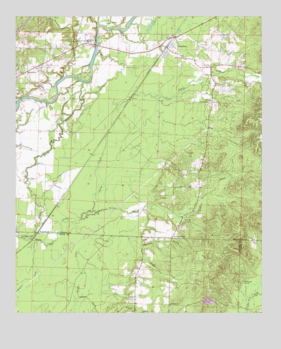
Donaldson, AR USGS Topographic Map
Click on map above to begin viewing in our Map Viewer.

This topographic map contains these locations and features:
Feature Name Type Latitude Longitude GNIS ID View Map
Anchor Baptist ChurchChurchN34.1643°W92.9149°76168View Map
Brown SpringsPopulated PlaceN34.1570°W92.9207°76430View Map
Brown Springs BranchStreamN34.1651°W92.9674°47012View Map
Cox BayouGutN34.2137°W92.9610°48125View Map
DeLisle CreekStreamN34.2251°W92.9746°48415View Map
DonaldsonPopulated PlaceN34.2368°W92.9235°57673View Map
Donaldson City MarshalBuildingN34.2371°W92.9230°2118835View Map
Donaldson Post OfficePost OfficeN34.2376°W92.9229°84356View Map
Donaldson SchoolSchoolN34.2326°W92.9160°48565View Map
Dutherage SpringSpringN34.1380°W92.8841°48722View Map
Easley CreekStreamN34.1651°W92.9674°48746View Map
FaberPopulated PlaceN34.1684°W92.9363°57735View Map
Friendship Post OfficePost OfficeN34.2241°W93.0000°2781924View Map
Jones CemeteryCemeteryN34.1781°W92.9132°50720View Map
Marshall BranchStreamN34.1565°W92.9427°51691View Map
Midway CemeteryCemeteryN34.2393°W92.9699°51944View Map
Mount Moriah Baptist ChurchChurchN34.1290°W92.9218°77722View Map
Mount Pleasant CemeteryCemeteryN34.2287°W92.9871°52384View Map
Ouachita CemeteryCemeteryN34.2384°W92.9077°53087View Map
Ouachita ChurchChurchN34.2295°W92.9007°53088View Map
Ouachita Elementary SchoolSchoolN34.2417°W92.9644°66129View Map
Ouachita Fire DepartmentBuildingN34.2401°W92.9645°2116915View Map
Ouachita Fire Department Donaldson StationBuildingN34.2376°W92.9228°2116916View Map
Ouachita High SchoolSchoolN34.2397°W92.9636°53090View Map
Riverside Baptist ChurchChurchN34.2395°W92.9657°78184View Map
Town of DonaldsonCivilN34.2341°W92.9186°2406386View Map
Township of Brown SpringsCivilN34.1812°W92.9470°66654View Map
Township of OuachitaCivilN34.2290°W92.9067°66667View Map
West Fork DeLisle CreekStreamN34.2487°W92.9816°56182View Map
White Oak CreekStreamN34.1568°W92.9960°56274View Map
Williams BranchStreamN34.1295°W92.9693°56383View Map
WitherspoonPopulated PlaceN34.1590°W92.9891°57237View Map

Note: Coordinates in the location and feature list above are referenced to NAD83 datum.


Copyright (C) 2008-2024 Ryan Niemi / Sunset Dynamics ... All Rights Reserved