TopoQuest Logo
Do you find TopoQuest useful?
Help keep TopoQuest running and adding new maps/features by donating!
Bitcoin:  19c7KJd3qBynnjoSw5npx9KScwjBe4ifkT
Litecoin:  LXs6TkuXGGXo1vDsWCkWVdjQX94eUKd6ui
Home View Maps Find Maps Find Places Resources & Links


Social Hill, Arkansas Topographic Map

USGS Map Title: Social Hill, AR
USGS Map MRC: 34092C8
DRG (GeoTIFF) Download: o34092c8.tif


Neighboring USGS Topographic Map Quads:


  Hot Springs South, AR  
34093D1
 

  Lake Catherine, AR  
34092D8
 

  Malvern North, AR  
34092D7
 

  De Roche, AR  
34093C1
 

  Social Hill, AR  
34092C8
 

  Malvern South, AR  
34092C7
 

  Caddo Valley, AR  
34093B1
 

  Donaldson, AR  
34092B8
 

  Round Hill, AR  
34092B7


Map MRC Location:

N35°
W93°
N35°
W92°
H8 H7 H6 H5 H4 H3 H2 H1
G8 G7 G6 G5 G4 G3 G2 G1
F8 F7 F6 F5 F4 F3 F2 F1
E8 E7 E6 E5 E4 E3 E2 E1
D8 D7 D6 D5 D4 D3 D2 D1
C8 C7 C6 C5 C4 C3 C2 C1
B8 B7 B6 B5 B4 B3 B2 B1
A8 A7 A6 A5 A4 A3 A2 A1
N34°
W93°
N34°
W92°

Social Hill, AR USGS 1:24K Topographic Map Preview:
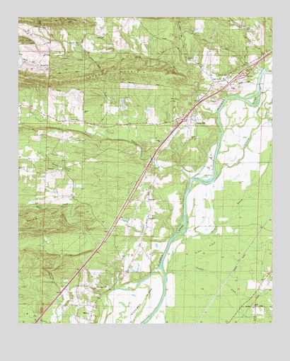
Social Hill, AR USGS Topographic Map
Click on map above to begin viewing in our Map Viewer.

This topographic map contains these locations and features:
Feature Name Type Latitude Longitude GNIS ID View Map
Alford CemeteryCemeteryN34.3665°W92.9624°45820View Map
AntiochPopulated PlaceN34.3118°W92.9868°57271View Map
Antioch ChurchChurchN34.3134°W92.9996°76176View Map
Antioch CreekStreamN34.2987°W92.9718°45902View Map
Antioch School (historical)SchoolN34.3129°W92.9771°66069View Map
Black BranchStreamN34.2734°W92.9191°46662View Map
Blakely CreekStreamN34.3362°W92.9021°46690View Map
Chatman CreekStreamN34.3340°W92.8813°47715View Map
Drowning SloughGutN34.3276°W92.8857°48612View Map
Easely MountainRidgeN34.3526°W92.9535°48743View Map
Elmo FlatsFlatN34.2804°W92.9091°48881View Map
Etta (historical)Populated PlaceN34.2895°W92.8799°66088View Map
Hot Spring CountyCivilN34.3176°W92.9460°66859View Map
Interchange 91CrossingN34.3334°W92.9188°58946View Map
Kokomo CreekStreamN34.3343°W92.8785°50910View Map
Lee CreekStreamN34.3537°W92.8796°51048View Map
Lone Hill CemeteryCemeteryN34.3515°W92.8974°51396View Map
MidwayPopulated PlaceN34.2543°W92.9635°58171View Map
Morrison IslandIslandN34.2570°W92.9441°52222View Map
Mountain Valley ChurchChurchN34.3640°W92.9718°52498View Map
Mountain Valley School (historical)SchoolN34.3643°W92.9716°66121View Map
Neighbors CemeteryCemeteryN34.2651°W92.9560°77799View Map
North Fork Blakely CreekStreamN34.3520°W92.9193°52819View Map
Oak GrovePopulated PlaceN34.3484°W92.9041°58288View Map
Prairie BayouStreamN34.3084°W92.9157°53755View Map
SaginawPopulated PlaceN34.3004°W92.9363°57176View Map
Saginaw ChurchChurchN34.2926°W92.9363°54304View Map
Social HillPopulated PlaceN34.3320°W92.9132°78400View Map
Southwest Rural Community Volunteer Fire Department MainBuildingN34.3324°W92.9273°2117156View Map
Southwest Rural Community Volunteer Fire Department SubstationBuildingN34.3125°W92.9793°2117157View Map
Tenmile CreekStreamN34.2698°W92.9279°55490View Map
Town of MidwayCivilN34.2524°W92.9687°2406162View Map
Township of Alford (historical)CivilN34.3695°W92.9946°66235View Map
Township of AntiochCivilN34.3087°W92.9925°66651View Map
Township of Lone HillCivilN34.3441°W92.9354°66663View Map
Township of PrairieCivilN34.2505°W92.9892°66668View Map
Ward CemeteryCemeteryN34.3334°W92.9741°56039View Map

Note: Coordinates in the location and feature list above are referenced to NAD83 datum.


Copyright (C) 2008-2024 Ryan Niemi / Sunset Dynamics ... All Rights Reserved