TopoQuest Logo
Do you find TopoQuest useful?
Help keep TopoQuest running and adding new maps/features by donating!
Bitcoin:  19c7KJd3qBynnjoSw5npx9KScwjBe4ifkT
Litecoin:  LXs6TkuXGGXo1vDsWCkWVdjQX94eUKd6ui
Home View Maps Find Maps Find Places Resources & Links


Dongola, South Carolina Topographic Map

USGS Map Title: Dongola, SC
USGS Map MRC: 33079G2
DRG (GeoTIFF) Download: o33079g2.tif


Neighboring USGS Topographic Map Quads:


  Brittons Neck, SC  
33079H3
 

  Horry, SC  
33079H2
 

  Adrian, SC  
33079H1
 

  Snow Island, SC  
33079G3
 

  Dongola, SC  
33079G2
 

  Conway, SC  
33079G1
 

  Outland, SC  
33079F3
 

  Yauhannah, SC  
33079F2
 

  Bucksville, SC  
33079F1


Map MRC Location:

N34°
W80°
N34°
W79°
H8 H7 H6 H5 H4 H3 H2 H1
G8 G7 G6 G5 G4 G3 G2 G1
F8 F7 F6 F5 F4 F3 F2 F1
E8 E7 E6 E5 E4 E3 E2 E1
D8 D7 D6 D5 D4 D3 D2 D1
C8 C7 C6 C5 C4 C3 C2 C1
B8 B7 B6 B5 B4 B3 B2 B1
A8 A7 A6 A5 A4 A3 A2 A1
N33°
W80°
N33°
W79°

Dongola, SC USGS 1:24K Topographic Map Preview:
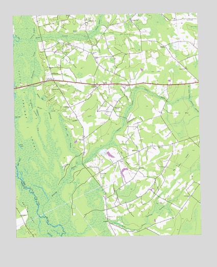
Dongola, SC USGS Topographic Map
Click on map above to begin viewing in our Map Viewer.

This topographic map contains these locations and features:
Feature Name Type Latitude Longitude GNIS ID View Map
Alfred CreekStreamN33.8216°W79.2287°1220157View Map
Antioch ChurchChurchN33.8532°W79.1962°1244899View Map
Atkinson BranchStreamN33.8616°W79.2392°1220265View Map
Big Cypress SwampStreamN33.8018°W79.1859°1220696View Map
Boyd CanalCanalN33.8421°W79.1606°1220915View Map
Brown Pond Dam D-3628DamN33.7768°W79.1898°1240148View Map
Brown SwampStreamN33.8618°W79.2459°1247011View Map
Browns ChurchChurchN33.7929°W79.1784°1247019View Map
BrownwayPopulated PlaceN33.7977°W79.1662°1221030View Map
Brownway BranchStreamN33.8127°W79.1759°1221031View Map
Brownway School (historical)SchoolN33.7932°W79.1770°1243625View Map
Bunker HillPopulated PlaceN33.8338°W79.2192°1231105View Map
Bunker Hill BranchStreamN33.8307°W79.2356°1221125View Map
BurganPopulated PlaceN33.8502°W79.1945°1231106View Map
Burgan (historical)Populated PlaceN33.8377°W79.2164°1243628View Map
Calhoun BranchStreamN33.8618°W79.2006°1221202View Map
Canon HillPopulated PlaceN33.7863°W79.1928°1221332View Map
Cates BayBasinN33.8188°W79.1359°1221399View Map
Cedar Grove BranchStreamN33.8268°W79.1317°1221449View Map
Cedar Grove Church (historical)ChurchN33.8360°W79.1789°1243640View Map
Church BranchStreamN33.8285°W79.2317°1221589View Map
Davis BranchStreamN33.8735°W79.1900°1221935View Map
DongolaPopulated PlaceN33.7574°W79.1870°1231233View Map
Dwight CreekStreamN33.8241°W79.2356°1222166View Map
ForneyPopulated PlaceN33.8354°W79.1739°1247803View Map
Forney BranchStreamN33.8216°W79.1714°1222497View Map
Greenwood ChurchChurchN33.7716°W79.1323°1245845View Map
Guiton CrossingPopulated PlaceN33.8566°W79.1473°1231350View Map
Hendricks CornerPopulated PlaceN33.8216°W79.1828°1227915View Map
Horry County Fire Department Station 16BuildingN33.7875°W79.1897°2368376View Map
Hunting SwampStreamN33.7621°W79.2300°1223403View Map
James CreekStreamN33.7902°W79.2487°1223509View Map
James LakeLakeN33.8015°W79.2463°1223514View Map
Jenkins SwampStreamN33.8321°W79.1673°1246160View Map
Juniper BayStreamN33.8618°W79.1970°1223683View Map
Juniper BayPopulated PlaceN33.8713°W79.1695°1227925View Map
Juniper Bay ChurchChurchN33.8716°W79.1703°1243796View Map
Kudge BaySwampN33.8655°W79.2078°1223774View Map
Lewis Mill BranchStreamN33.8663°W79.2212°1223885View Map
Little Pee Dee SwampSwampN33.8143°W79.2412°1224024View Map
Mack James PondReservoirN33.7958°W79.1854°1238802View Map
Martin Duck PondReservoirN33.7885°W79.1648°1240147View Map
Martin Duck Pond Dam D-3630DamN33.7885°W79.1648°1240146View Map
Martins Fishing PondReservoirN33.7868°W79.1764°1238795View Map
Ned SwampPopulated PlaceN33.8718°W79.1312°1231582View Map
New Hope ChurchChurchN33.8002°W79.1528°1224987View Map
Oak Grove ChurchChurchN33.8532°W79.2134°1249911View Map
Oak Grove Church (historical)ChurchN33.7654°W79.2487°1230834View Map
Oakey BayPopulated PlaceN33.8438°W79.1331°1227953View Map
Oakey Swamp ChurchChurchN33.8438°W79.1328°1243869View Map
Old Antioch CemeteryCemeteryN33.8585°W79.2125°1225166View Map
Old Antioch ChurchChurchN33.8582°W79.2128°1243876View Map
Page LakeLakeN33.8174°W79.2492°1220112View Map
Pauley Swamp Baptist ChurchChurchN33.7571°W79.1848°1243884View Map
Pauley Swamp CemeteryCemeteryN33.7574°W79.1853°1243885View Map
Pawleys SwampSwampN33.7709°W79.1414°1250041View Map
Pawleys Swamp ChurchChurchN33.7579°W79.1867°1243886View Map
Pawleys Swamp School (historical)SchoolN33.7571°W79.1862°1243887View Map
Pee Dee CrossroadsPopulated PlaceN33.8385°W79.2225°1227959View Map
Pee Dee Elementary SchoolSchoolN33.8144°W79.1506°1243891View Map
Pee Dee School (historical)SchoolN33.8363°W79.1937°1243890View Map
Punchbowl LandingLocaleN33.7568°W79.2189°1243926View Map
Red HillLocaleN33.8052°W79.2031°1250306View Map
Red Hill BranchStreamN33.8163°W79.2178°1225784View Map
Running BranchStreamN33.8510°W79.2353°1226071View Map
Sandy Island LakeLakeN33.8174°W79.2492°1226368View Map
Sarah BranchStreamN33.7591°W79.1892°1226400View Map
Sedge MarshSwampN33.7608°W79.2339°1226485View Map
Singleton CreekStreamN33.8610°W79.2353°1226645View Map
Singleton CrossroadsPopulated PlaceN33.8357°W79.1953°1231802View Map
Singleton IslandIslandN33.8221°W79.2370°1226646View Map
Skippers Chapel (historical)ChurchN33.8579°W79.1637°1243965View Map
South Carolina Noname 26032 D-3629 DamDamN33.7868°W79.1764°1238794View Map
South Carolina Noname 26041 D-3631 DamDamN33.7985°W79.1864°1238801View Map
Todd Mill BranchStreamN33.8624°W79.2203°1227165View Map
TwelvemilePopulated PlaceN33.8232°W79.2117°1231874View Map
WoodburyPopulated PlaceN33.7629°W79.2467°1228005View Map

Note: Coordinates in the location and feature list above are referenced to NAD83 datum.


Copyright (C) 2008-2025 Ryan Niemi / Sunset Dynamics ... All Rights Reserved