TopoQuest Logo
Do you find TopoQuest useful?
Help keep TopoQuest running and adding new maps/features by donating!
Bitcoin:  19c7KJd3qBynnjoSw5npx9KScwjBe4ifkT
Litecoin:  LXs6TkuXGGXo1vDsWCkWVdjQX94eUKd6ui
Home View Maps Find Maps Find Places Resources & Links


Bucksville, South Carolina Topographic Map

USGS Map Title: Bucksville, SC
USGS Map MRC: 33079F1
DRG (GeoTIFF) Download: o33079f1.tif


Neighboring USGS Topographic Map Quads:


  Dongola, SC  
33079G2
 

  Conway, SC  
33079G1
 

  Nixonville, SC  
33078G8
 

  Yauhannah, SC  
33079F2
 

  Bucksville, SC  
33079F1
 

  Myrtle Beach, SC  
33078F8
 

  Plantersville, SC  
33079E2
 

  Brookgreen, SC  
33079E1
 

  Surfside Beach, SC  
33078E8


Map MRC Location:

N34°
W80°
N34°
W79°
H8 H7 H6 H5 H4 H3 H2 H1
G8 G7 G6 G5 G4 G3 G2 G1
F8 F7 F6 F5 F4 F3 F2 F1
E8 E7 E6 E5 E4 E3 E2 E1
D8 D7 D6 D5 D4 D3 D2 D1
C8 C7 C6 C5 C4 C3 C2 C1
B8 B7 B6 B5 B4 B3 B2 B1
A8 A7 A6 A5 A4 A3 A2 A1
N33°
W80°
N33°
W79°

Bucksville, SC USGS 1:24K Topographic Map Preview:
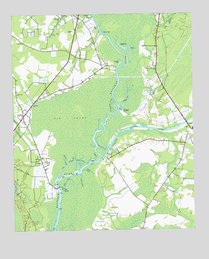
Bucksville, SC USGS Topographic Map
Click on map above to begin viewing in our Map Viewer.

This topographic map contains these locations and features:
Feature Name Type Latitude Longitude GNIS ID View Map
Big Buckskin CreekStreamN33.6932°W79.0567°1220690View Map
Browns ChapelChurchN33.7204°W79.0592°1243623View Map
Buck GraveyardCemeteryN33.7154°W79.0675°1243626View Map
BucksportPopulated PlaceN33.6649°W79.1025°1231099View Map
Bucksport Census Designated PlaceCensusN33.6706°W79.1102°2402728View Map
Bucksport School (historical)SchoolN33.6827°W79.1112°1706215View Map
BucksvillePopulated PlaceN33.7188°W79.0628°1247045View Map
Burgess Elementary SchoolSchoolN33.6340°W79.0112°2486533View Map
Clark CreekStreamN33.6577°W79.0789°1221609View Map
CoopersPopulated PlaceN33.6891°W79.0061°1243674View Map
Ebenezar SchoolSchoolN33.7399°W79.0839°1222206View Map
Ebenezer Church (historical)ChurchN33.7404°W79.0803°1243702View Map
Eddy Lake (historical)Populated PlaceN33.6502°W79.1206°1243703View Map
Enterprise CreekStreamN33.6704°W79.0606°1222297View Map
Enterprise LandingPopulated PlaceN33.6691°W79.0606°1247682View Map
Grace ChapelChurchN33.6854°W79.1153°1245798View Map
Halfway SwampStreamN33.7491°W79.0681°1222983View Map
Hebron ChurchChurchN33.7157°W79.0675°1245938View Map
Horry County Fire Department ScipioBuildingN33.6329°W79.0118°2368450View Map
Horry County Fire Department SocasteeBuildingN33.6778°W79.0001°2368313View Map
Horry County Fire Department Station 3BuildingN33.7018°W79.1066°2368297View Map
Horry County Memorial Library Bucksport BranchBuildingN33.6966°W79.1132°2490375View Map
Horry County Memorial Library Socastee BranchBuildingN33.6826°W79.0016°2490393View Map
Horry County Police Department South PrecinctBuildingN33.6340°W79.0112°2334986View Map
Jerusalem ChurchChurchN33.6910°W79.1134°1243793View Map
Keys FieldPopulated PlaceN33.7435°W79.0678°1231448View Map
KlondikePopulated PlaceN33.6910°W79.1178°1246264View Map
Little Lamb ChurchChurchN33.7041°W79.1223°1224011View Map
Mills PondReservoirN33.7048°W79.0279°1224581View Map
Mount Moriah ChurchChurchN33.6621°W79.1045°1706221View Map
Nimrod CreekStreamN33.6629°W79.0887°1225052View Map
Oatbed CreekStreamN33.6657°W79.0684°1225155View Map
Oatbed IslandIslandN33.6649°W79.0700°1225156View Map
Old Dock CreekStreamN33.6482°W79.0920°1225174View Map
Old Mill LakeLakeN33.7218°W79.0500°1225201View Map
Old RiverStreamN33.6554°W79.0948°1225209View Map
Old Womans LakeLakeN33.7321°W79.0495°1249980View Map
Osprey MarinaLocaleN33.6808°W79.0414°2490417View Map
Palmetto Bays Elementary SchoolSchoolN33.7297°W79.0207°2486571View Map
Peach CreekStreamN33.6599°W79.0770°1225331View Map
Peachtree Ferry (historical)CrossingN33.6952°W79.0509°1243888View Map
Peachtree LakeLakeN33.7010°W79.0450°1225333View Map
Peachtree LandingPopulated PlaceN33.6946°W79.0484°1227958View Map
Port Harrelson (historical)Populated PlaceN33.6802°W79.1192°1243919View Map
Raccoon Run Golf ClubLocaleN33.6459°W79.0396°2490049View Map
Ransoms BluffCliffN33.7496°W79.0703°1225752View Map
Rheuark LandingPopulated PlaceN33.7307°W79.0423°1231719View Map
Richardson SchoolSchoolN33.6666°W79.1062°1225861View Map
Righthand CreekStreamN33.6491°W79.0903°1225883View Map
Saint James ChurchChurchN33.6254°W79.0356°1226117View Map
Salem ChurchChurchN33.6668°W79.1053°1706224View Map
Schwartz Wastewater Treatment PlantLocaleN33.6428°W79.0436°2490492View Map
Seven ProngsGutN33.6657°W79.0789°1231792View Map
Socastee Census Designated PlaceCensusN33.6871°W79.0087°2402863View Map
Socastee Church (historical)ChurchN33.6752°W79.0050°1243966View Map
Socastee Church of GodChurchN33.7092°W79.0261°2490264View Map
Socastee CreekStreamN33.6718°W79.0603°1226741View Map
Socastee Elementary SchoolSchoolN33.6837°W79.0002°2486457View Map
Socastee Middle SchoolSchoolN33.6832°W79.0000°1243968View Map
Socastee United Methodist ChurchChurchN33.6835°W79.0025°1243969View Map
Strons LakeLakeN33.7396°W79.0611°1226938View Map
Toddville ChurchChurchN33.7396°W79.0800°1243996View Map
Virgo SchoolSchoolN33.7338°W79.1178°1251300View Map
Waccamaw ChurchChurchN33.6977°W79.1112°1251302View Map

Note: Coordinates in the location and feature list above are referenced to NAD83 datum.


Copyright (C) 2008-2024 Ryan Niemi / Sunset Dynamics ... All Rights Reserved