TopoQuest Logo
Do you find TopoQuest useful?
Help keep TopoQuest running and adding new maps/features by donating!
Bitcoin:  19c7KJd3qBynnjoSw5npx9KScwjBe4ifkT
Litecoin:  LXs6TkuXGGXo1vDsWCkWVdjQX94eUKd6ui
Home View Maps Find Maps Find Places Resources & Links


Dough Mountain, New Mexico Topographic Map

USGS Map Title: Dough Mountain, NM
USGS Map MRC: 34107H3
DRG (GeoTIFF) Download: o34107h3.tif


Neighboring USGS Topographic Map Quads:


  Laguna, NM  
35107A4
 

  Mesita, NM  
35107A3
 

  Mesa Gigante, NM  
35107A2
 

  South Butte, NM  
34107H4
 

  Dough Mountain, NM  
34107H3
 

  Correo, NM  
34107H2
 

  Marmon Ranch, NM  
34107G4
 

  Cerro Verde, NM  
34107G3
 

  White Ridge, NM  
34107G2


Map MRC Location:

N35°
W108°
N35°
W107°
H8 H7 H6 H5 H4 H3 H2 H1
G8 G7 G6 G5 G4 G3 G2 G1
F8 F7 F6 F5 F4 F3 F2 F1
E8 E7 E6 E5 E4 E3 E2 E1
D8 D7 D6 D5 D4 D3 D2 D1
C8 C7 C6 C5 C4 C3 C2 C1
B8 B7 B6 B5 B4 B3 B2 B1
A8 A7 A6 A5 A4 A3 A2 A1
N34°
W108°
N34°
W107°

Dough Mountain, NM USGS 1:24K Topographic Map Preview:
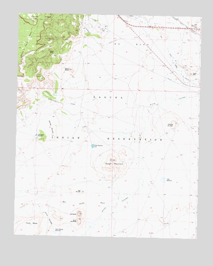
Dough Mountain, NM USGS Topographic Map
Click on map above to begin viewing in our Map Viewer.

This topographic map contains these locations and features:
Feature Name Type Latitude Longitude GNIS ID View Map
Arroyo ConchasStreamN34.9967°W107.2864°900297View Map
Big Sandy WashStreamN34.8995°W107.2964°886327View Map
Cottonwood CreekStreamN34.9570°W107.3064°887913View Map
Crow MesaSummitN34.9637°W107.3587°888109View Map
Dirty PointSummitN34.9950°W107.2548°888403View Map
Dough MountainRangeN34.9181°W107.3078°897357View Map
Dough Mountain LakeLakeN34.9262°W107.3224°888493View Map
El RitoPopulated PlaceN34.9992°W107.3000°898769View Map
Flat ReservoirReservoirN34.9079°W107.2734°889076View Map
Johnson SpringSpringN34.9785°W107.3505°890518View Map
Kose Sheep CampLocaleN34.8828°W107.2689°890751View Map
Laguna 2 Water WellWellN34.9912°W107.3150°918710View Map
Laguna 3 Water WellWellN34.9909°W107.3181°918709View Map
Laguna Compressor StationLocaleN34.9937°W107.3150°928970View Map
Lava ButteSummitN34.8878°W107.3303°890984View Map
Mesita BlancaSummitN34.9689°W107.3389°891898View Map
New MountainSummitN34.9003°W107.3289°892450View Map
Rolling MoundsSummitN34.9364°W107.3503°894132View Map
S Pino 2 Water WellWellN34.9698°W107.2595°918557View Map
Schcro GanaSummitN34.9678°W107.2550°894626View Map
Shonagana ReservoirReservoirN34.9314°W107.3607°894807View Map
South Laguna MinesMineN34.9864°W107.3506°895077View Map
South Lava ButteSummitN34.8848°W107.3306°895080View Map
South PassageAreaN34.8850°W107.3520°895095View Map
South Passage ReservoirsReservoirN34.8766°W107.3435°895096View Map
Standing Twin PeakSummitN34.9400°W107.2664°895300View Map
Windmill Number 9LocaleN34.9253°W107.2500°898221View Map

Note: Coordinates in the location and feature list above are referenced to NAD83 datum.


Copyright (C) 2008-2025 Ryan Niemi / Sunset Dynamics ... All Rights Reserved