TopoQuest Logo
Do you find TopoQuest useful?
Help keep TopoQuest running and adding new maps/features by donating!
Bitcoin:  19c7KJd3qBynnjoSw5npx9KScwjBe4ifkT
Litecoin:  LXs6TkuXGGXo1vDsWCkWVdjQX94eUKd6ui
Home View Maps Find Maps Find Places Resources & Links


Douglas, Wyoming Topographic Map

USGS Map Title: Douglas, WY
USGS Map MRC: 42105G4
DRG (GeoTIFF) Download: o42105g4.tif


Neighboring USGS Topographic Map Quads:


  Gilbert Lake, WY  
42105H5
 

  Sundquist Ranch, WY  
42105H4
 

  Clausen Ranch, WY  
42105H3
 

  Orpha, WY  
42105G5
 

  Douglas, WY  
42105G4
 

  Antelope Creek, WY  
42105G3
 

  La Prele Reservoir, WY  
42105F5
 

  Chalk Buttes, WY  
42105F4
 

  Irvine, WY  
42105F3


Map MRC Location:

N43°
W106°
N43°
W105°
H8 H7 H6 H5 H4 H3 H2 H1
G8 G7 G6 G5 G4 G3 G2 G1
F8 F7 F6 F5 F4 F3 F2 F1
E8 E7 E6 E5 E4 E3 E2 E1
D8 D7 D6 D5 D4 D3 D2 D1
C8 C7 C6 C5 C4 C3 C2 C1
B8 B7 B6 B5 B4 B3 B2 B1
A8 A7 A6 A5 A4 A3 A2 A1
N42°
W106°
N42°
W105°

Douglas, WY USGS 1:24K Topographic Map Preview:
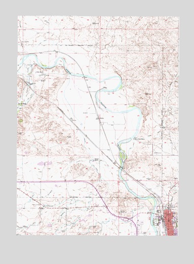
Douglas, WY USGS Topographic Map
Click on map above to begin viewing in our Map Viewer.

This topographic map contains these locations and features:
Feature Name Type Latitude Longitude GNIS ID View Map
Albert Sims Fee Land MineMineN42.7689°W105.3814°1746915View Map
Anderson PitMineN42.7561°W105.3897°1746916View Map
Antelope CreekStreamN42.7636°W105.3930°1584859View Map
Bill Hooker MonumentParkN42.7666°W105.4792°1585539View Map
Bozeman Trail MarkerParkN42.8361°W105.4905°1585871View Map
Camp Douglas POWs CemeteryCemeteryN42.7582°W105.4061°2774543View Map
Carmen PitMineN42.7597°W105.3897°1746912View Map
City of DouglasCivilN42.7547°W105.3835°2410350View Map
Converse County AirportAirportN42.7991°W105.3847°1608986View Map
Converse County AmbulanceBuildingN42.7588°W105.3802°2673655View Map
Converse County Sheriff's OfficeBuildingN42.7599°W105.3809°2752654View Map
DouglasPopulated PlaceN42.7597°W105.3822°1587750View Map
Douglas Fishing Lake Number 1ReservoirN42.7556°W105.4746°1606121View Map
Douglas Fishing Lake Number 1 DamDamN42.7566°W105.4739°1606120View Map
Douglas High SchoolSchoolN42.7597°W105.3822°1795455View Map
Douglas Intermediate SchoolSchoolN42.7597°W105.3822°1795457View Map
Douglas Middle SchoolSchoolN42.7597°W105.3822°1795456View Map
Douglas Police DepartmentBuildingN42.7598°W105.3838°2752647View Map
Douglas Post OfficePost OfficeN42.7607°W105.3838°2767839View Map
Douglas Primary SchoolSchoolN42.7597°W105.3822°1795458View Map
Douglas Volunteer Fire DepartmentBuildingN42.7619°W105.3857°2673455View Map
Dry Creek SchoolSchoolN42.7597°W105.3822°1795459View Map
East Antelope CreekStreamN42.7658°W105.3839°1588016View Map
Fetterman CreekStreamN42.8516°W105.4950°1596820View Map
Fivemile CreekStreamN42.7869°W105.4205°1588539View Map
Fleming RanchLocaleN42.8233°W105.4989°1588582View Map
Fort Fetterman CemeteryCemeteryN42.8380°W105.4785°1588637View Map
Fort Fetterman PitMineN42.7553°W105.3775°1746917View Map
Gibbs RanchLocaleN42.8430°W105.4858°1588893View Map
Harvey GulchValleyN42.8064°W105.4078°1589358View Map
KWIV-AM (Douglas)TowerN42.7633°W105.3928°1608799View Map
La Prele CreekStreamN42.8491°W105.4944°1600769View Map
Lisco PitMineN42.7606°W105.3972°1746918View Map
McComb Retirement CenterHospitalN42.7597°W105.3822°1794864View Map
Memorial Hospital of Converse CountyHospitalN42.7589°W105.3806°1794882View Map
Michael Manor Health Care CenterHospitalN42.7597°W105.3822°1794904View Map
Miner Sand and Gravel PitMineN42.7552°W105.4039°1746913View Map
MortonLocaleN42.8166°W105.4358°1597418View Map
Morton DitchCanalN42.8464°W105.4828°1591775View Map
Moss Agate SchoolSchoolN42.7597°W105.3822°1795460View Map
Nachtman SchoolSchoolN42.7597°W105.3822°1795461View Map
Pioneer CemeteryCemeteryN42.7784°W105.3917°2774551View Map
Recluse PitMineN42.7867°W105.4414°1746914View Map
River Bend RanchLocaleN42.8055°W105.4086°1593479View Map
Shawnee SchoolSchoolN42.7597°W105.3822°1795462View Map
Site of Hog RanchLocaleN42.8597°W105.4964°1594388View Map
Site of Old Fort FettermanLocaleN42.8402°W105.4797°1594389View Map
Sixmile CreekStreamN42.7797°W105.4155°1594395View Map
Underwood AirportAirportN42.8510°W105.4978°2717242View Map
Wagonhound SchoolSchoolN42.7597°W105.3822°1795463View Map
Warner DamDamN42.7900°W105.4789°1606035View Map
Warner Number 2 DamDamN42.7900°W105.4739°1606057View Map
Warner RanchLocaleN42.7930°W105.4394°1596046View Map
Warner ReservoirReservoirN42.7907°W105.4811°1606036View Map
Warner Reservoir Number 2ReservoirN42.7909°W105.4750°1606058View Map
Washington ParkCemeteryN42.7583°W105.3774°2774553View Map
White SchoolSchoolN42.7597°W105.3822°1795464View Map
Wintermote PitMineN42.7553°W105.3911°1746919View Map

Note: Coordinates in the location and feature list above are referenced to NAD83 datum.


Copyright (C) 2008-2025 Ryan Niemi / Sunset Dynamics ... All Rights Reserved