TopoQuest Logo
Do you find TopoQuest useful?
Help keep TopoQuest running and adding new maps/features by donating!
Bitcoin:  19c7KJd3qBynnjoSw5npx9KScwjBe4ifkT
Litecoin:  LXs6TkuXGGXo1vDsWCkWVdjQX94eUKd6ui
Home View Maps Find Maps Find Places Resources & Links


Dover, Arkansas Topographic Map

USGS Map Title: Dover, AR
USGS Map MRC: 35093D1
DRG (GeoTIFF) Download: o35093d1.tif


Neighboring USGS Topographic Map Quads:


  Treat, AR  
35093E2
 

  Simpson, AR  
35093E1
 

  Solo, AR  
35092E8
 

  Lee Mountain, AR  
35093D2
 

  Dover, AR  
35093D1
 

  Hector, AR  
35092D8
 

  Russellville West, AR  
35093C2
 

  Russellville East, AR  
35093C1
 

  Moreland, AR  
35092C8


Map MRC Location:

N36°
W94°
N36°
W93°
H8 H7 H6 H5 H4 H3 H2 H1
G8 G7 G6 G5 G4 G3 G2 G1
F8 F7 F6 F5 F4 F3 F2 F1
E8 E7 E6 E5 E4 E3 E2 E1
D8 D7 D6 D5 D4 D3 D2 D1
C8 C7 C6 C5 C4 C3 C2 C1
B8 B7 B6 B5 B4 B3 B2 B1
A8 A7 A6 A5 A4 A3 A2 A1
N35°
W94°
N35°
W93°

Dover, AR USGS 1:24K Topographic Map Preview:
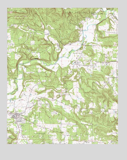
Dover, AR USGS Topographic Map
Click on map above to begin viewing in our Map Viewer.

This topographic map contains these locations and features:
Feature Name Type Latitude Longitude GNIS ID View Map
Brooks CemeteryCemeteryN35.4348°W93.1163°70833View Map
BroomfieldPopulated PlaceN35.4765°W93.0785°62042View Map
Broomfield ChurchChurchN35.4767°W93.0780°70838View Map
Cedar Grove Assembly of God ChurchChurchN35.4359°W93.0010°76561View Map
City of DoverCivilN35.3913°W93.1143°2403504View Map
College HillSummitN35.3995°W93.1182°62034View Map
Cottonwood School (historical)SchoolN35.4148°W93.0682°62041View Map
DoverPopulated PlaceN35.4015°W93.1143°79133View Map
Dover City Volunteer Fire StationBuildingN35.4024°W93.1140°2116369View Map
Dover College (historical)SchoolN35.3995°W93.1182°62033View Map
Dover Elementary SchoolSchoolN35.4023°W93.1149°62035View Map
Dover Gas FieldOilfieldN35.4154°W93.0602°62040View Map
Dover High SchoolSchoolN35.3973°W93.1166°62032View Map
Dover Intermediate SchoolSchoolN35.3996°W93.1183°2039105View Map
Dover Middle SchoolSchoolN35.3996°W93.1167°2039106View Map
Dover Police DepartmentBuildingN35.4019°W93.1139°2118881View Map
Dover Primary SchoolSchoolN35.4022°W93.1151°2039111View Map
Dover Rural Volunteer Fire DepartmentBuildingN35.4034°W93.1224°2116370View Map
Dover Work CenterLocaleN35.3998°W93.1107°74502View Map
Fairview Church CemeteryCemeteryN35.3856°W93.0643°71578View Map
Goates CemeteryCemeteryN35.4784°W93.0421°71771View Map
Gum CreekStreamN35.4156°W93.0946°62038View Map
Hatley Baptist Church (historical)ChurchN35.3829°W93.0574°81606View Map
Hatley CemeteryCemeteryN35.3829°W93.0577°81607View Map
Hatley Fire StationBuildingN35.3862°W93.0642°2116546View Map
Hatley School (historical)SchoolN35.3834°W93.0602°62039View Map
Jamison CemeteryCemeteryN35.3990°W93.1182°64924View Map
Lake CemeteryCemeteryN35.4159°W93.1191°72278View Map
Landers Loop AirportAirportN35.3972°W93.0680°83680View Map
Langford CemeteryCemeteryN35.4581°W93.0471°72289View Map
Little CreekStreamN35.4487°W93.0757°72384View Map
Little CreekStreamN35.4515°W93.0874°72386View Map
McFadden CemeteryCemeteryN35.3920°W93.1124°72593View Map
Mill CreekStreamN35.4976°W93.0066°72664View Map
Mud CreekStreamN35.4156°W93.0974°62037View Map
Newton School (historical)SchoolN35.4509°W93.0021°62044View Map
Newton Springs ChurchChurchN35.4512°W93.0018°72865View Map
North Fork Illinois BayouStreamN35.4973°W93.0138°77860View Map
Phoenix ChurchChurchN35.4054°W93.0113°73067View Map
Phoenix School (historical)SchoolN35.4037°W93.0116°62043View Map
Pine Hill Chapel (historical)ChurchN35.4345°W93.0891°64928View Map
Pine Hill School (historical)SchoolN35.4342°W93.0891°62036View Map
Pope CountyCivilN35.4476°W93.0342°69901View Map
Pope County Emergency Medical Service Station 4BuildingN35.4022°W93.1138°2119141View Map
Price Grove ChurchChurchN35.4909°W93.0346°73201View Map
Prices Grove School (historical)SchoolN35.4909°W93.0346°62046View Map
ScottsvillePopulated PlaceN35.4487°W93.0466°78306View Map
Scottsville Gas FieldOilfieldN35.4559°W93.0177°62045View Map
Stout CemeteryCemeteryN35.3851°W93.1029°64936View Map
Three Knob MountainSummitN35.4956°W93.1066°73868View Map
Township of DoverCivilN35.3934°W93.1162°69702View Map
Township of PhoenixCivilN35.4044°W93.0162°69712View Map

Note: Coordinates in the location and feature list above are referenced to NAD83 datum.


Copyright (C) 2008-2024 Ryan Niemi / Sunset Dynamics ... All Rights Reserved