TopoQuest Logo
Do you find TopoQuest useful?
Help keep TopoQuest running and adding new maps/features by donating!
Bitcoin:  19c7KJd3qBynnjoSw5npx9KScwjBe4ifkT
Litecoin:  LXs6TkuXGGXo1vDsWCkWVdjQX94eUKd6ui
Home View Maps Find Maps Find Places Resources & Links


Simpson, Arkansas Topographic Map

USGS Map Title: Simpson, AR
USGS Map MRC: 35093E1
DRG (GeoTIFF) Download: o35093e1.tif


Neighboring USGS Topographic Map Quads:


  Fort Douglas, AR  
35093F2
 

  Sand Gap, AR  
35093F1
 

  Smyrna, AR  
35092F8
 

  Treat, AR  
35093E2
 

  Simpson, AR  
35093E1
 

  Solo, AR  
35092E8
 

  Lee Mountain, AR  
35093D2
 

  Dover, AR  
35093D1
 

  Hector, AR  
35092D8


Map MRC Location:

N36°
W94°
N36°
W93°
H8 H7 H6 H5 H4 H3 H2 H1
G8 G7 G6 G5 G4 G3 G2 G1
F8 F7 F6 F5 F4 F3 F2 F1
E8 E7 E6 E5 E4 E3 E2 E1
D8 D7 D6 D5 D4 D3 D2 D1
C8 C7 C6 C5 C4 C3 C2 C1
B8 B7 B6 B5 B4 B3 B2 B1
A8 A7 A6 A5 A4 A3 A2 A1
N35°
W94°
N35°
W93°

Simpson, AR USGS 1:24K Topographic Map Preview:
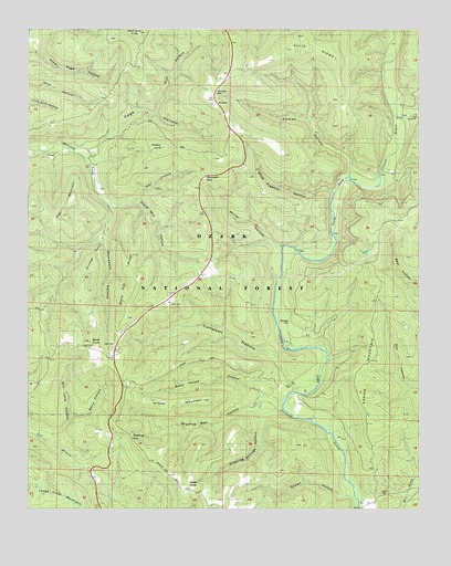
Simpson, AR USGS Topographic Map
Click on map above to begin viewing in our Map Viewer.

This topographic map contains these locations and features:
Feature Name Type Latitude Longitude GNIS ID View Map
Adams MountainSummitN35.5398°W93.0177°59186View Map
Bates KnobSummitN35.5437°W93.1052°59170View Map
Berry HollowValleyN35.5245°W93.1113°59168View Map
Birch CemeteryCemeteryN35.5037°W93.0121°78877View Map
Black Oak RidgeRidgeN35.5584°W93.0918°59172View Map
Bob Bates ForkStreamN35.5240°W93.0405°62005View Map
Bursh SchoolSchoolN35.5026°W93.0121°83400View Map
Campbell HollowStreamN35.5306°W93.0424°74066View Map
Cowan CreekStreamN35.5867°W93.0227°62007View Map
Cowan HollowValleyN35.5862°W93.0238°71264View Map
Cowan Hollow TrailTrailN35.5906°W93.0377°71265View Map
Cowan Spring SchoolSchoolN35.5884°W93.0216°71267View Map
Dollar KnobSummitN35.5059°W93.0746°59178View Map
Dripping Springs HollowValleyN35.5279°W93.0507°59179View Map
Dripping Springs HollowValleyN35.5234°W93.0393°74314View Map
Dry CreekStreamN35.6015°W93.0080°71444View Map
Ellis RidgeRidgeN35.6201°W93.0338°59185View Map
Elmer Page HollowValleyN35.6201°W93.1230°59177View Map
Epson HollowValleyN35.5023°W93.0193°74311View Map
Epson HollowValleyN35.5037°W93.0235°59187View Map
Gap HollowValleyN35.5795°W93.0980°71723View Map
Grannys GapGapN35.5190°W93.0918°81376View Map
Grannys Gap HollowValleyN35.5279°W93.0518°59180View Map
Grannys Gap HollowValleyN35.5290°W93.0507°74370View Map
Gulf HollowValleyN35.6042°W93.0841°71851View Map
High MountainSummitN35.5767°W93.1143°59176View Map
Ladd School Number 2SchoolN35.5426°W93.1116°82469View Map
Lane CemeteryCemeteryN35.5429°W93.0971°59171View Map
Laurel (historical)Populated PlaceN35.5229°W93.0252°62009View Map
Macassin HollowValleyN35.5709°W93.1013°74321View Map
Middle MountainSummitN35.5284°W93.0677°59181View Map
Middle MountainSummitN35.5276°W93.0805°74316View Map
Mineral Spring School (historical)SchoolN35.5684°W93.0343°62008View Map
Mitchell PointCapeN35.5667°W93.1041°59173View Map
Mitchell PointSummitN35.5667°W93.1043°74322View Map
Mocassin HollowValleyN35.5701°W93.1007°59174View Map
Moccasin GapGapN35.5867°W93.0699°72710View Map
Mose Freeman HollowValleyN35.5826°W93.0271°72738View Map
Mount Pleasant SchoolSchoolN35.5048°W93.0716°72767View Map
Oak Grove CemeteryCemeteryN35.6094°W93.0648°74310View Map
Oak Grove School (historical)SchoolN35.6087°W93.0660°62006View Map
Page HollowValleyN35.5956°W93.1043°72979View Map
Roc House HollowValleyN35.5295°W93.0502°59182View Map
Rock House HollowValleyN35.5292°W93.0485°74320View Map
Rock House HollowValleyN35.5284°W93.0474°56903View Map
Sherman CemeteryCemeteryN35.5490°W93.0416°74319View Map
SimpsonPopulated PlaceN35.6073°W93.0660°73583View Map
Stave Mill HollowValleyN35.5798°W93.0905°59175View Map
Stave Mill HollowValleyN35.5801°W93.0913°74308View Map
TagPopulated PlaceN35.5315°W93.0416°73816View Map
Township of Hogan (historical)CivilN35.5334°W93.0488°70142View Map
Township of LibertyCivilN35.5040°W93.0537°69709View Map
Township of North Fork (historical)CivilN35.6001°W93.0043°70146View Map
West Fork Illinois BayouStreamN35.5304°W93.0402°74315View Map
West Fork North Fork Illinois BayouStreamN35.5306°W93.0405°59183View Map
Whaley KnobSummitN35.5945°W93.0810°59184View Map
Will Lane HollowValleyN35.5187°W93.1168°59169View Map
Will Lane HollowValleyN35.5181°W93.1205°74317View Map
Winter HollowValleyN35.5676°W93.0441°74182View Map

Note: Coordinates in the location and feature list above are referenced to NAD83 datum.


Copyright (C) 2008-2024 Ryan Niemi / Sunset Dynamics ... All Rights Reserved