TopoQuest Logo
Do you find TopoQuest useful?
Help keep TopoQuest running and adding new maps/features by donating!
Bitcoin:  19c7KJd3qBynnjoSw5npx9KScwjBe4ifkT
Litecoin:  LXs6TkuXGGXo1vDsWCkWVdjQX94eUKd6ui
Home View Maps Find Maps Find Places Resources & Links


Dover, Pennsylvania Topographic Map

USGS Map Title: Dover, PA
USGS Map MRC: 40076A7
DRG (GeoTIFF) Download: o40076a7.tif


Neighboring USGS Topographic Map Quads:


  Lemoyne, PA  
40076B8
 

  Steelton, PA  
40076B7
 

  Middletown, PA  
40076B6
 

  Wellsville, PA  
40076A8
 

  Dover, PA  
40076A7
 

  York Haven, PA  
40076A6
 

  Abbottstown, PA  
39076H8
 

  West York, PA  
39076H7
 

  York, PA  
39076H6


Map MRC Location:

N41°
W77°
N41°
W76°
H8 H7 H6 H5 H4 H3 H2 H1
G8 G7 G6 G5 G4 G3 G2 G1
F8 F7 F6 F5 F4 F3 F2 F1
E8 E7 E6 E5 E4 E3 E2 E1
D8 D7 D6 D5 D4 D3 D2 D1
C8 C7 C6 C5 C4 C3 C2 C1
B8 B7 B6 B5 B4 B3 B2 B1
A8 A7 A6 A5 A4 A3 A2 A1
N40°
W77°
N40°
W76°

Dover, PA USGS 1:24K Topographic Map Preview:
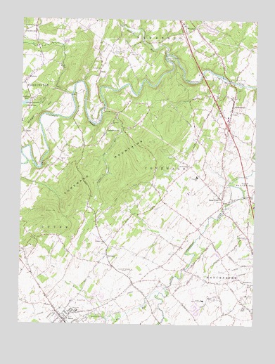
Dover, PA USGS Topographic Map
Click on map above to begin viewing in our Map Viewer.

This topographic map contains these locations and features:
Feature Name Type Latitude Longitude GNIS ID View Map
AlpinePopulated PlaceN40.0787°W76.8728°1192068View Map
AndersontownPopulated PlaceN40.0793°W76.8283°1168294View Map
Aughenbaugh ChurchChurchN40.0359°W76.7522°1168506View Map
Baney's Airport (historical)AirportN40.0182°W76.8193°2442991View Map
Beaver CreekStreamN40.0943°W76.8477°1169000View Map
Bennett RunStreamN40.1106°W76.7969°1169252View Map
Bethany ChurchChurchN40.0340°W76.8297°1169342View Map
Borough of DoverCivilN40.0033°W76.8484°1215740View Map
BrandywinePopulated PlaceN40.0112°W76.7702°1196340View Map
Brookside ParkParkN40.0023°W76.8330°1170347View Map
Cann-Edi-On CampLocaleN40.1095°W76.7955°1171159View Map
Conewago MountainRangeN40.0468°W76.8580°1172323View Map
Conewago SchoolSchoolN40.0590°W76.7805°1211216View Map
Country Club EstatesPopulated PlaceN40.0068°W76.7811°1196339View Map
Country Club WestPopulated PlaceN40.0151°W76.7814°1196338View Map
DoverPopulated PlaceN40.0018°W76.8502°1192368View Map
Dover Area Ambulance ClubBuildingN40.0025°W76.8484°2722323View Map
Dover Area Elementary SchoolSchoolN40.0054°W76.8439°1210564View Map
Dover Assembly Church of GodChurchN40.0070°W76.8566°1196337View Map
Dover Post OfficePost OfficeN40.0020°W76.8514°2756679View Map
EastmontPopulated PlaceN40.0287°W76.8277°1173923View Map
Emmanuel ChurchChurchN40.1223°W76.8680°1174229View Map
ErneyPopulated PlaceN40.1029°W76.8327°1174310View Map
Fox RunStreamN40.0132°W76.7994°1175105View Map
Grace ChurchChurchN40.0168°W76.7514°1175886View Map
Holy Saviour CemeteryCemeteryN40.0284°W76.7502°1177288View Map
Kise Mill BridgeBridgeN40.1161°W76.8106°2723098View Map
Kise Mill Bridge Historic DistrictParkN40.1161°W76.8100°2723099View Map
Laurel RunStreamN40.0865°W76.8311°1178975View Map
Lazy B Ranch AirportAirportN40.0262°W76.8134°2442989View Map
Manchester Township Fire Department and Emergency Medical ServicesBuildingN40.0205°W76.7535°2653171View Map
MaytownPopulated PlaceN40.0998°W76.8725°1204121View Map
Mount Gospel Mission Church (historical)ChurchN40.0923°W76.7858°1211217View Map
Mount Grove ChurchChurchN40.0823°W76.8258°1181694View Map
Mount Washington ChurchChurchN40.0651°W76.7841°1181885View Map
Northern York County Regional Police DepartmentBuildingN40.0082°W76.8286°2099976View Map
Outdoor Country Club of YorkLocaleN40.0101°W76.7764°1213312View Map
Pinchot Lake DamDamN40.0901°W76.8714°1194525View Map
Quickels Church (historical)ChurchN40.0504°W76.7661°1211218View Map
Rohlers ChurchChurchN40.0679°W76.8536°1185398View Map
RoundtownPopulated PlaceN40.0179°W76.7555°1185568View Map
Roundtown Elementary SchoolSchoolN40.0126°W76.7536°1210967View Map
Saint James ChurchChurchN40.1051°W76.8322°1186012View Map
Stony RunStreamN40.0970°W76.8561°1188803View Map
StrinestownPopulated PlaceN40.0912°W76.7614°1188881View Map
Strinestown Community Fire Company Station 26BuildingN40.0907°W76.7623°2100071View Map
Suburban Memorial GardensCemeteryN40.0212°W76.8164°1188916View Map
Susquehanna SpeedwayLocaleN40.1126°W76.8250°1213373View Map
Township of ConewagoCivilN40.0658°W76.7932°1217283View Map
Township of DoverCivilN40.0020°W76.8699°1217284View Map
Township of ManchesterCivilN40.0128°W76.7538°1217296View Map
Union Fire and Hose Company 1 Station 6 DoverBuildingN40.0025°W76.8484°2652713View Map
WoodsidePopulated PlaceN40.1220°W76.7816°1191770View Map
WRHY-FM (Starview)TowerN40.0748°W76.8000°1200189View Map
Zions ViewPopulated PlaceN40.0529°W76.7683°1192018View Map

Note: Coordinates in the location and feature list above are referenced to NAD83 datum.


Copyright (C) 2008-2024 Ryan Niemi / Sunset Dynamics ... All Rights Reserved