TopoQuest Logo
Do you find TopoQuest useful?
Help keep TopoQuest running and adding new maps/features by donating!
Bitcoin:  19c7KJd3qBynnjoSw5npx9KScwjBe4ifkT
Litecoin:  LXs6TkuXGGXo1vDsWCkWVdjQX94eUKd6ui
Home View Maps Find Maps Find Places Resources & Links


Wellsville, Pennsylvania Topographic Map

USGS Map Title: Wellsville, PA
USGS Map MRC: 40076A8
DRG (GeoTIFF) Download: o40076a8.tif


Neighboring USGS Topographic Map Quads:


  Mechanicsburg, PA  
40077B1
 

  Lemoyne, PA  
40076B8
 

  Steelton, PA  
40076B7
 

  Dillsburg, PA  
40077A1
 

  Wellsville, PA  
40076A8
 

  Dover, PA  
40076A7
 

  Hampton, PA  
39077H1
 

  Abbottstown, PA  
39076H8
 

  West York, PA  
39076H7


Map MRC Location:

N41°
W77°
N41°
W76°
H8 H7 H6 H5 H4 H3 H2 H1
G8 G7 G6 G5 G4 G3 G2 G1
F8 F7 F6 F5 F4 F3 F2 F1
E8 E7 E6 E5 E4 E3 E2 E1
D8 D7 D6 D5 D4 D3 D2 D1
C8 C7 C6 C5 C4 C3 C2 C1
B8 B7 B6 B5 B4 B3 B2 B1
A8 A7 A6 A5 A4 A3 A2 A1
N40°
W77°
N40°
W76°

Wellsville, PA USGS 1:24K Topographic Map Preview:
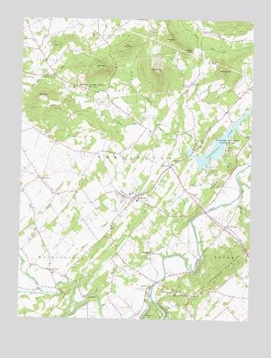
Wellsville, PA USGS Topographic Map
Click on map above to begin viewing in our Map Viewer.

This topographic map contains these locations and features:
Feature Name Type Latitude Longitude GNIS ID View Map
Balanced RockSummitN40.0801°W76.8839°1202166View Map
BenedictsPopulated PlaceN40.0268°W76.9280°1203062View Map
Bermudian CreekStreamN40.0093°W76.9280°1192124View Map
Big Rock SchoolSchoolN40.0509°W76.9022°1211140View Map
Blair HillSummitN40.0929°W76.9875°1169790View Map
Borough of WellsvilleCivilN40.0513°W76.9407°1215764View Map
Boulder PointLocaleN40.0793°W76.8830°1207398View Map
Carroll Township Police DepartmentBuildingN40.1097°W76.9879°2099971View Map
Carroll Township Police DepartmentBuildingN40.1096°W76.9879°2780230View Map
Chestnut Grove ChurchChurchN40.1159°W76.9936°1171713View Map
Detters MillPopulated PlaceN40.0143°W76.9272°1173182View Map
Doe RunStreamN40.0151°W76.9725°1198056View Map
Elcock SchoolhouseSchoolN40.0887°W76.9486°1211145View Map
Flat MountainSummitN40.1131°W76.9416°1174883View Map
FortneyPopulated PlaceN40.0990°W76.9069°1175024View Map
Fortney P O (historical)BuildingN40.0981°W76.9069°1211143View Map
Gifford Pinchot State ParkParkN40.0718°W76.8880°1175599View Map
Hall P O (historical)BuildingN40.0195°W76.9808°1211149View Map
Harmony GrovePopulated PlaceN40.0104°W76.9078°1176553View Map
Johns KnobSummitN40.1079°W76.8972°1178104View Map
Kampel AirportAirportN40.0511°W76.9754°1193811View Map
KralltownPopulated PlaceN40.0198°W76.9828°1178660View Map
Minebank Schoolhouse (historical)SchoolN40.0359°W76.9728°1211146View Map
Mount AiryPopulated PlaceN40.0990°W76.9066°1211144View Map
Mount Airy ChurchChurchN40.0973°W76.9089°1181634View Map
Mount Oliver ChurchChurchN40.0276°W76.9272°1181772View Map
Mount Pleasant SchoolhouseSchoolN40.0507°W76.9661°1211435View Map
Mount RoyalPopulated PlaceN40.0393°W76.8878°1181842View Map
Mount TopPopulated PlaceN40.0587°W76.9891°1204232View Map
Mount Zion ChurchChurchN40.0734°W76.9803°1181916View Map
Mud RunStreamN40.0112°W76.9772°1182033View Map
Myers CemeteryCemeteryN40.1231°W76.9275°1182130View Map
Nells HillSummitN40.1051°W76.9566°1182237View Map
North Branch Beaver CreekStreamN40.0829°W76.9286°1182523View Map
North Branch Bermudian CreekStreamN40.0118°W76.9886°1182524View Map
Old Toboggan Run RocksCliffN40.0668°W76.8880°1202365View Map
Pickett HillSummitN40.0004°W76.9291°1183699View Map
Pinchot LakeReservoirN40.0739°W76.8921°1192291View Map
PinetownPopulated PlaceN40.1201°W76.9008°1204405View Map
Pinetown HillSummitN40.1165°W76.9178°1183929View Map
Porters SchoolSchoolN40.1229°W76.9594°1211139View Map
Quaker Meetinghouse (historical)ChurchN40.0529°W76.9297°1211141View Map
Ramsey HillSummitN40.1037°W76.8886°1184631View Map
Rocky Spring CampLocaleN40.1143°W76.9833°1185372View Map
RolerPopulated PlaceN40.0129°W76.9222°1211147View Map
RosevillePopulated PlaceN40.0640°W76.9178°1185480View Map
Rossville Post OfficePost OfficeN40.0638°W76.9176°2756699View Map
Round TopSummitN40.1037°W76.9255°1185542View Map
Saint Johns ChurchChurchN40.0518°W76.9053°1186095View Map
Saint Michaels ChurchChurchN40.0659°W76.9141°1186487View Map
Salem CemeteryCemeteryN40.0564°W76.9045°1186806View Map
Salem Church (historical)ChurchN40.0559°W76.9069°1211142View Map
Shafer SchoolhouseSchoolN40.0070°W76.8858°1211148View Map
Shreveport North AirportAirportN40.0358°W76.9933°1193812View Map
Ski Roundtop Ski AreaLocaleN40.1068°W76.9264°1205823View Map
State Game Lands Number 242ParkN40.0968°W76.9578°1193447View Map
StevenstownPopulated PlaceN40.1015°W76.9875°1188641View Map
Straight HillSummitN40.0634°W76.8866°1188841View Map
Township of WarringtonCivilN40.0742°W76.9268°1217309View Map
Township of WashingtonCivilN40.0117°W76.9842°1217310View Map
UnoPopulated PlaceN40.1034°W76.9833°1204854View Map
Victory ChurchChurchN40.0745°W76.9005°1190400View Map
Walgamuth ChurchChurchN40.1009°W76.9941°1190497View Map
Weaver SchoolhouseSchoolN40.0109°W76.9508°1213101View Map
WellsvillePopulated PlaceN40.0515°W76.9366°1190817View Map
Wellsville Fire Company Station 66BuildingN40.0524°W76.9385°2653130View Map
Wellsville Post OfficePost OfficeN40.0503°W76.9395°2756693View Map
Wright KnobSummitN40.1123°W76.9111°1191803View Map

Note: Coordinates in the location and feature list above are referenced to NAD83 datum.


Copyright (C) 2008-2025 Ryan Niemi / Sunset Dynamics ... All Rights Reserved