TopoQuest Logo
Do you find TopoQuest useful?
Help keep TopoQuest running and adding new maps/features by donating!
Bitcoin:  19c7KJd3qBynnjoSw5npx9KScwjBe4ifkT
Litecoin:  LXs6TkuXGGXo1vDsWCkWVdjQX94eUKd6ui
Home View Maps Find Maps Find Places Resources & Links


Appling, Georgia Topographic Map

USGS Map Title: Appling, GA
USGS Map MRC: 33082E3
DRG (GeoTIFF) Download: o33082e3.tif


Neighboring USGS Topographic Map Quads:


  Woodlawn, GA  
33082F4
 

  Leah, GA  
33082F3
 

  Clarks Hill, SC  
33082F2
 

  Winfield, GA  
33082E4
 

  Appling, GA  
33082E3
 

  Evans, GA  
33082E2
 

  Thomson East, GA  
33082D4
 

  Harlem, GA  
33082D3
 

  Grovetown, GA  
33082D2


Map MRC Location:

N34°
W83°
N34°
W82°
H8 H7 H6 H5 H4 H3 H2 H1
G8 G7 G6 G5 G4 G3 G2 G1
F8 F7 F6 F5 F4 F3 F2 F1
E8 E7 E6 E5 E4 E3 E2 E1
D8 D7 D6 D5 D4 D3 D2 D1
C8 C7 C6 C5 C4 C3 C2 C1
B8 B7 B6 B5 B4 B3 B2 B1
A8 A7 A6 A5 A4 A3 A2 A1
N33°
W83°
N33°
W82°

Appling, GA USGS 1:24K Topographic Map Preview:
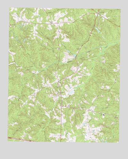
Appling, GA USGS Topographic Map
Click on map above to begin viewing in our Map Viewer.

This topographic map contains these locations and features:
Feature Name Type Latitude Longitude GNIS ID View Map
ApplingPopulated PlaceN33.5460°W82.3160°354381View Map
Appling Census Designated PlaceCensusN33.5588°W82.3183°2746617View Map
Appling ChurchChurchN33.5454°W82.3193°348963View Map
Appling DivisionCivilN33.5963°W82.3123°1936081View Map
Appling Grove ChurchChurchN33.5476°W82.3398°348964View Map
Appling Post OfficePost OfficeN33.5349°W82.3142°348842View Map
Bailey BranchStreamN33.5804°W82.2976°310718View Map
Bennett DamDamN33.6001°W82.3248°338738View Map
Bennett LakeReservoirN33.6011°W82.3237°338739View Map
Carpenter AirportAirportN33.5222°W82.3722°2442641View Map
Casaga LakeReservoirN33.5813°W82.3009°339452View Map
Casaga Lake DamDamN33.5801°W82.2998°339451View Map
Cluese (historical)Populated PlaceN33.6121°W82.3565°348864View Map
Columbia CountyCivilN33.5441°W82.2641°348865View Map
Columbia County CourthouseBuildingN33.5465°W82.3165°348866View Map
Columbia County JailBuildingN33.5356°W82.3075°2734109View Map
Columbia County Sheriff's DepartmentBuildingN33.5357°W82.3072°2733571View Map
Columbia Middle SchoolSchoolN33.5260°W82.2675°355251View Map
Crawford LakeReservoirN33.5172°W82.2888°339450View Map
Crawford Lake DamDamN33.5185°W82.2865°339449View Map
Delph (historical)Populated PlaceN33.5729°W82.2504°348908View Map
Greenbrier CreekStreamN33.5882°W82.2673°356099View Map
Harris BranchStreamN33.5749°W82.3162°315176View Map
Hawes BranchStreamN33.5121°W82.3340°356225View Map
Hickory BranchStreamN33.5679°W82.3468°315359View Map
Hickory LakeReservoirN33.5945°W82.3576°339406View Map
Hickory Lake DamDamN33.5935°W82.3582°339405View Map
HowellPopulated PlaceN33.5565°W82.3179°332035View Map
Kelly BranchStreamN33.5824°W82.2735°348977View Map
Kiokee ChurchChurchN33.5518°W82.3187°356342View Map
Kiokee SchoolSchoolN33.5532°W82.3201°348978View Map
Lamkin Grove ChurchChurchN33.5668°W82.2512°316602View Map
Lamkin Grove School (historical)SchoolN33.5671°W82.2512°334146View Map
Lower Pollards LakeReservoirN33.5935°W82.2615°339436View Map
Lower Pollards Lake DamDamN33.5935°W82.2615°339435View Map
MaddoxPopulated PlaceN33.5301°W82.2848°348979View Map
Marshall MonumentParkN33.5454°W82.3157°348980View Map
Martinez - Columbia Fire Rescue Station 10BuildingN33.6097°W82.3242°2603580View Map
Martinez - Columbia Fire Rescue Station 12BuildingN33.5339°W82.3094°2604078View Map
Martinez - Columbia Fire Rescue Station 15BuildingN33.6165°W82.2639°2604687View Map
Mount Moriah ChurchChurchN33.5382°W82.3151°318701View Map
North Columbia Elementary SchoolSchoolN33.5876°W82.3186°320472View Map
Old Kiokee ChurchChurchN33.5779°W82.2918°319991View Map
Olive Grove ChurchChurchN33.5315°W82.2910°320050View Map
PhinizyPopulated PlaceN33.6104°W82.3262°326466View Map
Pollards CornerPopulated PlaceN33.6210°W82.2751°332720View Map
Pollards Corner LakeReservoirN33.6190°W82.2743°339438View Map
Pollards Corner Lake DamDamN33.6185°W82.2748°339437View Map
Pollards LakeReservoirN33.6054°W82.2753°339434View Map
Pollards Lake DamDamN33.6035°W82.2732°339433View Map
Satterwhite BranchStreamN33.5543°W82.3576°322581View Map
Shiloh ForkStreamN33.5657°W82.3404°322903View Map
Smith Church (historical)ChurchN33.5199°W82.2710°334149View Map
Smith Grove ChurchChurchN33.5274°W82.2690°323136View Map
Smith School (historical)SchoolN33.5279°W82.2721°334150View Map
Solid Rock ChurchChurchN33.5876°W82.2951°323215View Map
Susie Bostic CemeteryCemeteryN33.5468°W82.2635°348996View Map
Walnut Grove School (historical)SchoolN33.6068°W82.3201°334151View Map
White Oak BranchStreamN33.5232°W82.3287°325165View Map
WMTZ-FM (Martinez)TowerN33.5318°W82.2818°352732View Map

Note: Coordinates in the location and feature list above are referenced to NAD83 datum.


Copyright (C) 2008-2025 Ryan Niemi / Sunset Dynamics ... All Rights Reserved