TopoQuest Logo
Do you find TopoQuest useful?
Help keep TopoQuest running and adding new maps/features by donating!
Bitcoin:  19c7KJd3qBynnjoSw5npx9KScwjBe4ifkT
Litecoin:  LXs6TkuXGGXo1vDsWCkWVdjQX94eUKd6ui
Home View Maps Find Maps Find Places Resources & Links


Evans, Georgia Topographic Map

USGS Map Title: Evans, GA
USGS Map MRC: 33082E2
DRG (GeoTIFF) Download: o33082e2.tif


Neighboring USGS Topographic Map Quads:


  Leah, GA  
33082F3
 

  Clarks Hill, SC  
33082F2
 

  Colliers, SC  
33082F1
 

  Appling, GA  
33082E3
 

  Evans, GA  
33082E2
 

  Martinez, GA  
33082E1
 

  Harlem, GA  
33082D3
 

  Grovetown, GA  
33082D2
 

  Augusta West, GA  
33082D1


Map MRC Location:

N34°
W83°
N34°
W82°
H8 H7 H6 H5 H4 H3 H2 H1
G8 G7 G6 G5 G4 G3 G2 G1
F8 F7 F6 F5 F4 F3 F2 F1
E8 E7 E6 E5 E4 E3 E2 E1
D8 D7 D6 D5 D4 D3 D2 D1
C8 C7 C6 C5 C4 C3 C2 C1
B8 B7 B6 B5 B4 B3 B2 B1
A8 A7 A6 A5 A4 A3 A2 A1
N33°
W83°
N33°
W82°

Evans, GA USGS 1:24K Topographic Map Preview:
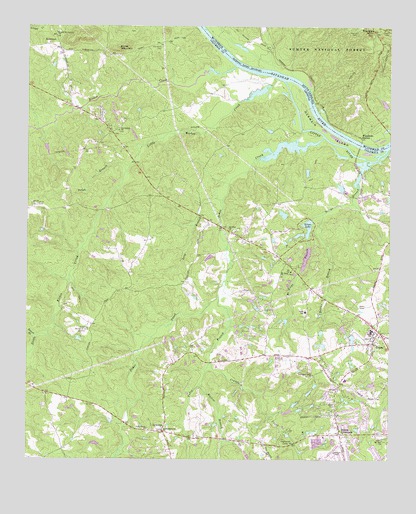
Evans, GA USGS Topographic Map
Click on map above to begin viewing in our Map Viewer.

This topographic map contains these locations and features:
Feature Name Type Latitude Longitude GNIS ID View Map
Bel Air Elementary SchoolSchoolN33.5232°W82.1400°348848View Map
Benton BranchStreamN33.5354°W82.2465°327073View Map
Bettys BranchStreamN33.5885°W82.1260°327095View Map
Bolgla LakeReservoirN33.5046°W82.2260°339440View Map
Bolgla Lake DamDamN33.5035°W82.2248°339439View Map
Burks MountainSummitN33.6187°W82.2187°331285View Map
Burks Mountain BarrensAreaN33.6183°W82.2174°2788098View Map
Calloway WoodsPopulated PlaceN33.5151°W82.1526°348855View Map
CamelotPopulated PlaceN33.5382°W82.1348°348857View Map
Camelot LakeReservoirN33.5378°W82.1406°339454View Map
Camelot Lake DamDamN33.5385°W82.1415°339453View Map
Chimney HillPopulated PlaceN33.5460°W82.1423°348862View Map
Clanttian Grove School (historical)SchoolN33.5135°W82.2210°348863View Map
Columbia County Marshal's DepartmentBuildingN33.5452°W82.1313°2734143View Map
Columbia County Sheriff's Office SubstationBuildingN33.5452°W82.1311°2734032View Map
Columbia Land Corporation LakeReservoirN33.5778°W82.1973°339442View Map
Columbia Land Corporation Lake DamDamN33.5785°W82.1998°339441View Map
Country PlacePopulated PlaceN33.5432°W82.1435°348870View Map
Crawford CreekStreamN33.5279°W82.1862°327549View Map
Crawford Grove ChurchChurchN33.5246°W82.1510°327550View Map
Deerwood AcresPopulated PlaceN33.5618°W82.1368°348872View Map
Deerwood EstatesPopulated PlaceN33.5701°W82.1401°348873View Map
Delph BranchStreamN33.5832°W82.2160°327626View Map
Enoch School (historical)SchoolN33.5343°W82.1660°348969View Map
EvansPopulated PlaceN33.5337°W82.1307°355729View Map
Evans Census Designated PlaceCensusN33.5619°W82.1351°2402464View Map
Evans DivisionCivilN33.5407°W82.1476°1936255View Map
Evans Elementary SchoolSchoolN33.5430°W82.1539°356010View Map
Evans High SchoolSchoolN33.5247°W82.1473°348881View Map
Evans Middle SchoolSchoolN33.5322°W82.1597°348882View Map
Evans Village Shopping CenterLocaleN33.5399°W82.1282°348879View Map
EvanstonPopulated PlaceN33.5251°W82.1496°348880View Map
Fairington EstatesPopulated PlaceN33.5224°W82.1957°348883View Map
Fanglewood CampLocaleN33.5060°W82.1621°327800View Map
Friendship ChurchChurchN33.5949°W82.2185°327887View Map
German IslandIslandN33.5954°W82.1479°356003View Map
GlennwoodPopulated PlaceN33.5193°W82.1468°348891View Map
Gold BranchStreamN33.6110°W82.1590°1252046View Map
Greenbrier Elementary SchoolSchoolN33.5870°W82.1893°2545722View Map
Greenbrier High SchoolSchoolN33.5888°W82.1922°2545794View Map
Greenbrier Middle SchoolSchoolN33.5885°W82.1874°2545572View Map
Hardys LakeReservoirN33.5787°W82.1416°348973View Map
Harvey Mill (historical)LocaleN33.5965°W82.1429°1252047View Map
Highview AcresPopulated PlaceN33.5010°W82.1429°348895View Map
HillbrookPopulated PlaceN33.5051°W82.1357°348897View Map
Hopewell CemeteryCemeteryN33.6246°W82.1379°1229814View Map
Idlewylde LakeReservoirN33.5268°W82.1278°339430View Map
Idlewylde Lake DamDamN33.5268°W82.1282°339429View Map
IdylwildePopulated PlaceN33.5224°W82.1332°348899View Map
Johnsons Spur (historical)LocaleN33.6201°W82.1660°1237448View Map
KiokeePopulated PlaceN33.5946°W82.2207°348905View Map
Kiokee CreekStreamN33.6137°W82.1779°356343View Map
Knox CemeteryCemeteryN33.5735°W82.2462°328421View Map
Lake Cumberland WestPopulated PlaceN33.5807°W82.1971°348906View Map
Lewis Memorial ChurchChurchN33.5085°W82.2026°328494View Map
LewistonPopulated PlaceN33.5101°W82.2021°332208View Map
Lewiston Elementary SchoolSchoolN33.5311°W82.1583°2545573View Map
Little Kiokee CreekStreamN33.6096°W82.1632°328557View Map
Long BranchStreamN33.5751°W82.1826°328610View Map
Martinez - Columbia Fire Rescue Station 2BuildingN33.5323°W82.1524°2604688View Map
Martinez - Columbia Fire Rescue Station 5BuildingN33.5657°W82.1762°2604838View Map
Martinez - Columbia Fire Rescue Station 6BuildingN33.5255°W82.2281°2604079View Map
McKie CemeteryCemeteryN33.6235°W82.1312°1229990View Map
McManus PondsReservoirN33.5750°W82.1354°348983View Map
MeadowviewPopulated PlaceN33.5071°W82.1273°348914View Map
Mill BranchStreamN33.5026°W82.2179°328777View Map
Mobile Home Park Lake AReservoirN33.5033°W82.1524°339446View Map
Mobile Home Park Lake BReservoirN33.5035°W82.1548°339444View Map
Mobile Home Park Lake Dam ADamN33.5035°W82.1515°339445View Map
Mobile Home Park Lake Dam BDamN33.5035°W82.1548°339443View Map
Mount Enna BranchStreamN33.5640°W82.1529°328871View Map
Mount Enna ChurchChurchN33.5540°W82.1582°328872View Map
Mount Olive ChurchChurchN33.5668°W82.1804°328881View Map
Mount Olive LakeReservoirN33.5709°W82.1615°339432View Map
Mount Olive Lake DamDamN33.5701°W82.1598°339431View Map
Mount Zion ChurchChurchN33.5062°W82.1287°328914View Map
Old Avery CemeteryCemeteryN33.6193°W82.2035°329088View Map
PinewoodPopulated PlaceN33.5101°W82.1440°348921View Map
Piney Grove ChurchChurchN33.5087°W82.2076°329231View Map
Riverside Elementary SchoolSchoolN33.5793°W82.1300°2545777View Map
Ropers CrossroadsPopulated PlaceN33.5074°W82.1412°329520View Map
RosemontPopulated PlaceN33.6196°W82.2426°332924View Map
Second Mount Carmel ChurchChurchN33.6229°W82.2404°329634View Map
SedgefieldPopulated PlaceN33.5118°W82.1332°348926View Map
ShadowmoorPopulated PlaceN33.5135°W82.1387°348927View Map
Shady Grove EstatesPopulated PlaceN33.5093°W82.1507°348928View Map
Silver LakeReservoirN33.5673°W82.1530°329706View Map
Silver Lake DamDamN33.5660°W82.1515°339403View Map
Smith LakeReservoirN33.5899°W82.2435°339448View Map
Smith Lake DamDamN33.5901°W82.2432°339447View Map
SmithwyckPopulated PlaceN33.5024°W82.1290°348933View Map
Snellings Memorial AcreCemeteryN33.5360°W82.2315°329750View Map
South Carolina Noname 35007 D-0638 DamDamN33.6018°W82.1265°1238855View Map
Tanglewood CampLocaleN33.5062°W82.1615°348997View Map
Trinity ChurchChurchN33.5065°W82.1471°348998View Map
Tudor BranchStreamN33.5471°W82.1835°330058View Map
Uchee CreekStreamN33.5937°W82.1473°356605View Map
Walton BranchStreamN33.5218°W82.1901°330154View Map
Whispering Pine Mobile Home ParkPopulated PlaceN33.5460°W82.1365°348954View Map
Windmill PlantationPopulated PlaceN33.5635°W82.2073°348955View Map
WoodbridgePopulated PlaceN33.5587°W82.1546°348958View Map
Woodbridge LakeReservoirN33.5585°W82.1534°339456View Map
Woodbridge Lake DamDamN33.5618°W82.1532°339455View Map
Woodlawn Lookout TowerTowerN33.6237°W82.1268°1252011View Map
Woodlawn StationLocaleN33.5932°W82.1348°1251502View Map
WymberlyPopulated PlaceN33.5057°W82.1496°348960View Map

Note: Coordinates in the location and feature list above are referenced to NAD83 datum.


Copyright (C) 2008-2024 Ryan Niemi / Sunset Dynamics ... All Rights Reserved