TopoQuest Logo
Do you find TopoQuest useful?
Help keep TopoQuest running and adding new maps/features by donating!
Bitcoin:  19c7KJd3qBynnjoSw5npx9KScwjBe4ifkT
Litecoin:  LXs6TkuXGGXo1vDsWCkWVdjQX94eUKd6ui
Home View Maps Find Maps Find Places Resources & Links


Arabela, New Mexico Topographic Map

USGS Map Title: Arabela, NM
USGS Map MRC: 33105E2
DRG (GeoTIFF) Download: o33105e2.tif


Neighboring USGS Topographic Map Quads:


  Kyle Harrison Canyon, NM  
33105F3
 

  Arroyo Serrano West, NM  
33105F2
 

  Arroyo Serrano East, NM  
33105F1
 

  Capitan Peak, NM  
33105E3
 

  Arabela, NM  
33105E2
 

  Granville Canyon, NM  
33105E1
 

  San Patricio, NM  
33105D3
 

  Nelson Canyon West, NM  
33105D2
 

  Nelson Canyon East, NM  
33105D1


Map MRC Location:

N34°
W106°
N34°
W105°
H8 H7 H6 H5 H4 H3 H2 H1
G8 G7 G6 G5 G4 G3 G2 G1
F8 F7 F6 F5 F4 F3 F2 F1
E8 E7 E6 E5 E4 E3 E2 E1
D8 D7 D6 D5 D4 D3 D2 D1
C8 C7 C6 C5 C4 C3 C2 C1
B8 B7 B6 B5 B4 B3 B2 B1
A8 A7 A6 A5 A4 A3 A2 A1
N33°
W106°
N33°
W105°

Arabela, NM USGS 1:24K Topographic Map Preview:
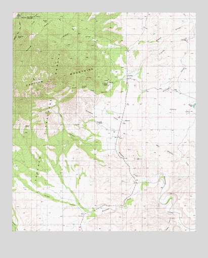
Arabela, NM USGS Topographic Map
Click on map above to begin viewing in our Map Viewer.

This topographic map contains these locations and features:
Feature Name Type Latitude Longitude GNIS ID View Map
10133 Water WellWellN33.5418°W105.1703°931737View Map
ArabelaPopulated PlaceN33.5870°W105.1733°903252View Map
Arabela Fire DepartmentBuildingN33.5641°W105.1757°2658040View Map
Arabela Mines Incorporated ProspectMineN33.6229°W105.2311°916208View Map
Arabela Post Office (historical)Post OfficeN33.5870°W105.1733°938085View Map
Arabela Weather StationLocaleN33.5870°W105.1733°931821View Map
BluewaterPopulated PlaceN33.5579°W105.1861°903960View Map
Bluewater Elementary SchoolSchoolN33.5579°W105.1861°925116View Map
Bluewater SpringSpringN33.5622°W105.1893°903967View Map
Boy Scout MountainSummitN33.6218°W105.2405°904048View Map
Chimney RockSummitN33.6109°W105.2497°905108View Map
Diablo CanyonValleyN33.5062°W105.1375°905749View Map
Duran CanyonValleyN33.6098°W105.1328°905908View Map
Encinoso CanyonValleyN33.6098°W105.1328°906171View Map
Escondido CreekStreamN33.5298°W105.1619°906186View Map
Hale CanyonValleyN33.5493°W105.1797°906808View Map
Las Palas CemeteryCemeteryN33.5851°W105.1816°1985397View Map
Las Palas SpringSpringN33.5840°W105.1858°1985396View Map
Matney SpringSpringN33.5600°W105.2416°913286View Map
Pacheco LakeLakeN33.5723°W105.1264°909421View Map
Pancho CanyonValleyN33.5090°W105.1925°909463View Map
Pine LodgePopulated PlaceN33.6231°W105.2450°909671View Map
Pine Lodge Post Office (historical)Post OfficeN33.6231°W105.2450°937235View Map
Pino Real SpringSpringN33.5811°W105.2077°909711View Map
RamerezSummitN33.6068°W105.1967°913132View Map
South ArabelaSummitN33.5415°W105.1636°1985398View Map
Sunset PeakSummitN33.5865°W105.2364°911497View Map
Whitaker RanchLocaleN33.5190°W105.2167°913131View Map

Note: Coordinates in the location and feature list above are referenced to NAD83 datum.


Copyright (C) 2008-2025 Ryan Niemi / Sunset Dynamics ... All Rights Reserved