TopoQuest Logo
Do you find TopoQuest useful?
Help keep TopoQuest running and adding new maps/features by donating!
Bitcoin:  19c7KJd3qBynnjoSw5npx9KScwjBe4ifkT
Litecoin:  LXs6TkuXGGXo1vDsWCkWVdjQX94eUKd6ui
Home View Maps Find Maps Find Places Resources & Links


Dudenville, Missouri Topographic Map

USGS Map Title: Dudenville, MO
USGS Map MRC: 37094C1
DRG (GeoTIFF) Download: o37094c1.tif


Neighboring USGS Topographic Map Quads:


  Kenoma, MO  
37094D2
 

  Golden City, MO  
37094D1
 

  Lockwood, MO  
37093D8
 

  Maple Grove, MO  
37094C2
 

  Dudenville, MO  
37094C1
 

  Kings Point, MO  
37093C8
 

  Avilla, MO  
37094B2
 

  La Russell, MO  
37094B1
 

  Rescue, MO  
37093B8


Map MRC Location:

N38°
W95°
N38°
W94°
H8 H7 H6 H5 H4 H3 H2 H1
G8 G7 G6 G5 G4 G3 G2 G1
F8 F7 F6 F5 F4 F3 F2 F1
E8 E7 E6 E5 E4 E3 E2 E1
D8 D7 D6 D5 D4 D3 D2 D1
C8 C7 C6 C5 C4 C3 C2 C1
B8 B7 B6 B5 B4 B3 B2 B1
A8 A7 A6 A5 A4 A3 A2 A1
N37°
W95°
N37°
W94°

Dudenville, MO USGS 1:24K Topographic Map Preview:
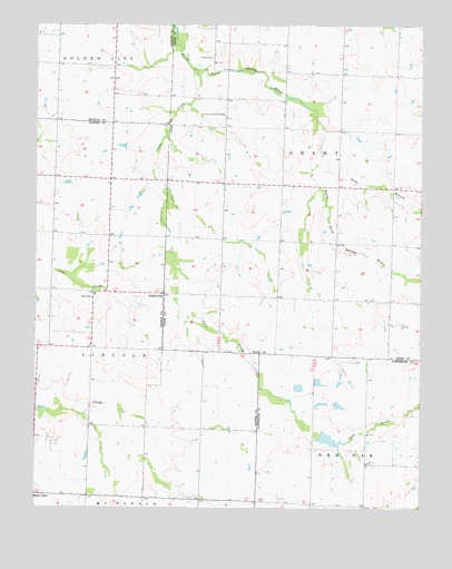
Dudenville, MO USGS Topographic Map
Click on map above to begin viewing in our Map Viewer.

This topographic map contains these locations and features:
Feature Name Type Latitude Longitude GNIS ID View Map
Ackley School (historical)SchoolN37.3095°W94.0658°746292View Map
Bowman School (historical)SchoolN37.3039°W94.0288°746291View Map
Coon CreekStreamN37.3637°W94.0736°716250View Map
Davis Lake DamDamN37.3534°W94.0419°763475View Map
DudenvillePopulated PlaceN37.3056°W94.0833°729877View Map
Fairview School (historical)SchoolN37.3731°W94.0263°746293View Map
Harlan Stump DamDamN37.2817°W94.0335°762909View Map
Kistler CemeteryCemeteryN37.3667°W94.0669°720655View Map
Leaming FieldAirportN37.2516°W94.0608°758696View Map
Number 71 LakeReservoirN37.2683°W94.0303°762964View Map
Pleasant View School (historical)SchoolN37.2673°W94.0180°746363View Map
Poirot Farms Incorporated DamDamN37.2784°W94.0435°763049View Map
Poirot Farms LakeReservoirN37.2773°W94.0422°763050View Map
Poirot Lake Dam Shallow DamDamN37.2684°W94.0319°762963View Map
Prairie Home School (historical)SchoolN37.3637°W94.1005°746210View Map
Pyle Lake DamDamN37.2634°W94.0285°763188View Map
Sams BranchStreamN37.3420°W94.0327°736031View Map
Schilling LakeReservoirN37.3101°W94.0402°762959View Map
Schilling Lake DamDamN37.3101°W94.0402°762958View Map
Sharon School (historical)SchoolN37.2716°W94.0715°746077View Map
Snowflake School (historical)SchoolN37.3356°W94.1058°746076View Map
Townley LakeReservoirN37.3434°W94.0536°762957View Map
Townley Lake DamDamN37.3434°W94.0536°762956View Map
Township of GrantCivilN37.3299°W94.0234°766552View Map
Township of LincolnCivilN37.2980°W94.1227°766812View Map
Unity School (historical)SchoolN37.3045°W94.1066°728060View Map
Victory Community CenterLocaleN37.3526°W94.0633°729979View Map

Note: Coordinates in the location and feature list above are referenced to NAD83 datum.


Copyright (C) 2008-2025 Ryan Niemi / Sunset Dynamics ... All Rights Reserved