TopoQuest Logo
Do you find TopoQuest useful?
Help keep TopoQuest running and adding new maps/features by donating!
Bitcoin:  19c7KJd3qBynnjoSw5npx9KScwjBe4ifkT
Litecoin:  LXs6TkuXGGXo1vDsWCkWVdjQX94eUKd6ui
Home View Maps Find Maps Find Places Resources & Links


Dundee, Minnesota Topographic Map

USGS Map Title: Dundee, MN
USGS Map MRC: 43095G4
DRG (GeoTIFF) Download: o43095g4.tif


Neighboring USGS Topographic Map Quads:


  Lime Creek, MN  
43095H5
 

  Heron Lake NW, MN  
43095H4
 

  Heron Lake NE, MN  
43095H3
 

  Fulda, MN  
43095G5
 

  Dundee, MN  
43095G4
 

  Heron Lake, MN  
43095G3
 

  Worthington North, MN  
43095F5
 

  Brewster, MN  
43095F4
 

  Okabena, MN  
43095F3


Map MRC Location:

N44°
W96°
N44°
W95°
H8 H7 H6 H5 H4 H3 H2 H1
G8 G7 G6 G5 G4 G3 G2 G1
F8 F7 F6 F5 F4 F3 F2 F1
E8 E7 E6 E5 E4 E3 E2 E1
D8 D7 D6 D5 D4 D3 D2 D1
C8 C7 C6 C5 C4 C3 C2 C1
B8 B7 B6 B5 B4 B3 B2 B1
A8 A7 A6 A5 A4 A3 A2 A1
N43°
W96°
N43°
W95°

Dundee, MN USGS 1:24K Topographic Map Preview:
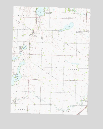
Dundee, MN USGS Topographic Map
Click on map above to begin viewing in our Map Viewer.

This topographic map contains these locations and features:
Feature Name Type Latitude Longitude GNIS ID View Map
Ball Field ParkParkN43.8444°W95.4683°2049005View Map
City of DundeeCivilN43.8441°W95.4667°2394573View Map
City of KinbraeCivilN43.8266°W95.4823°2395534View Map
Clear LakeLakeN43.8525°W95.4113°641273View Map
Cotton-Jack State Wildlife Management ArParkN43.8458°W95.3833°641527View Map
DundeePopulated PlaceN43.8469°W95.4669°642979View Map
Dundee (historical)LocaleN43.8458°W95.4669°2049000View Map
Dundee City ParkParkN43.8466°W95.4678°2049007View Map
Dundee Fire DepartmentBuildingN43.8453°W95.4665°2049004View Map
Dundee Post OfficePost OfficeN43.8469°W95.4669°2049002View Map
East Graham LakeLakeN43.7926°W95.4924°643078View Map
First Lutheran CemeteryCemeteryN43.8459°W95.4621°2049030View Map
First Lutheran ChurchChurchN43.8441°W95.4667°2049001View Map
Fred Hoffenkamp State Wildlife Management AreaParkN43.7639°W95.4961°2048835View Map
Fury Island ParkParkN43.7919°W95.4933°643994View Map
Fury State Wildlife Management AreaParkN43.7933°W95.4958°643995View Map
Jack LakeLakeN43.8137°W95.4960°645554View Map
KinbraePopulated PlaceN43.8258°W95.4872°646150View Map
Kinbrae CemeteryCemeteryN43.8122°W95.4925°646151View Map
Kinbrae LakeLakeN43.8275°W95.4803°646152View Map
Kinbrae Post Office (historical)Post OfficeN43.8258°W95.4872°2048877View Map
Kinbrae SloughLakeN43.8204°W95.4863°646153View Map
Rupp ParkParkN43.8461°W95.4661°2049006View Map
Saint Marys CemeteryCemeteryN43.8415°W95.4627°650845View Map
Talcot Lake County ParkParkN43.8639°W95.4544°2051025View Map
Talcot Lake Wildlife Area DamDamN43.8750°W95.4586°1776977View Map
Township of La CrosseCivilN43.8045°W95.3941°664653View Map

Note: Coordinates in the location and feature list above are referenced to NAD83 datum.


Copyright (C) 2008-2025 Ryan Niemi / Sunset Dynamics ... All Rights Reserved