TopoQuest Logo
Do you find TopoQuest useful?
Help keep TopoQuest running and adding new maps/features by donating!
Bitcoin:  19c7KJd3qBynnjoSw5npx9KScwjBe4ifkT
Litecoin:  LXs6TkuXGGXo1vDsWCkWVdjQX94eUKd6ui
Home View Maps Find Maps Find Places Resources & Links


Eads, Tennessee Topographic Map

USGS Map Title: Eads, TN
USGS Map MRC: 35089B6
DRG (GeoTIFF) Download: o35089b6.tif


Neighboring USGS Topographic Map Quads:


  Brunswick, TN  
35089C7
 

  Arlington, TN  
35089C6
 

  Gallaway, TN  
35089C5
 

  Ellendale, TN  
35089B7
 

  Eads, TN  
35089B6
 

  Oakland, TN  
35089B5
 

  Germantown, TN  
35089A7
 

  Collierville, TN  
35089A6
 

  Rossville, TN  
35089A5


Map MRC Location:

N36°
W90°
N36°
W89°
H8 H7 H6 H5 H4 H3 H2 H1
G8 G7 G6 G5 G4 G3 G2 G1
F8 F7 F6 F5 F4 F3 F2 F1
E8 E7 E6 E5 E4 E3 E2 E1
D8 D7 D6 D5 D4 D3 D2 D1
C8 C7 C6 C5 C4 C3 C2 C1
B8 B7 B6 B5 B4 B3 B2 B1
A8 A7 A6 A5 A4 A3 A2 A1
N35°
W90°
N35°
W89°

Eads, TN USGS 1:24K Topographic Map Preview:
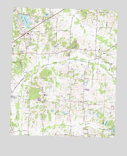
Eads, TN USGS Topographic Map
Click on map above to begin viewing in our Map Viewer.

This topographic map contains these locations and features:
Feature Name Type Latitude Longitude GNIS ID View Map
Baxter CemeteryCemeteryN35.1615°W89.6851°1276506View Map
Brooks CemeteryCemeteryN35.1898°W89.6573°1278467View Map
Chambers ChapelChurchN35.2129°W89.6990°1305843View Map
Chambers Chapel CemeteryCemeteryN35.2129°W89.6992°1325516View Map
Cotton Field AirportAirportN35.1891°W89.6385°2444023View Map
CrossroadsPopulated PlaceN35.1279°W89.6573°1281719View Map
Cypress Creek CanalCanalN35.2231°W89.6520°1281938View Map
Cypress Creek ChurchChurchN35.2401°W89.6495°1281939View Map
EadsPopulated PlaceN35.2045°W89.6492°1283276View Map
Eads Post OfficePost OfficeN35.2029°W89.6489°1652395View Map
Eads SchoolSchoolN35.2112°W89.6615°1306404View Map
Field CreekStreamN35.1940°W89.7095°1284232View Map
First Baptist Church of FishervilleChurchN35.1587°W89.6662°1325654View Map
Fisher DamDamN35.1901°W89.7384°1301648View Map
Fisher LakeReservoirN35.1913°W89.7401°1301647View Map
FishervillePopulated PlaceN35.1593°W89.6637°1284328View Map
Fisherville CemeteryCemeteryN35.1584°W89.6662°1326273View Map
Fisherville Division (historical)CensusN35.1543°W89.6970°1648955View Map
Fisherville FarmsLocaleN35.1767°W89.6661°2652508View Map
Fogelman DamDamN35.2368°W89.7084°1301672View Map
Fogelman LakeReservoirN35.2373°W89.7086°1301673View Map
Friendship TempleChurchN35.2076°W89.6406°1284952View Map
Grays Creek CanalCanalN35.1773°W89.7351°1286024View Map
Grays Creek CemeteryCemeteryN35.2120°W89.6820°1325740View Map
Grays Creek ChurchChurchN35.2115°W89.6812°1306511View Map
Guymon LakeReservoirN35.1716°W89.7127°1301639View Map
Guymon Lake DamDamN35.1718°W89.7117°1301638View Map
Herb Parsons Lake DamDamN35.1320°W89.6273°1307063View Map
Horse Crazy FarmsLocaleN35.2344°W89.6433°2635261View Map
Interchange 20CrossingN35.2231°W89.7367°1313613View Map
James SchoolSchoolN35.1815°W89.6623°1289282View Map
James School (historical)SchoolN35.1806°W89.6626°1325812View Map
LakelandPopulated PlaceN35.2306°W89.7404°1313627View Map
Lakeland DamDamN35.2431°W89.7367°1307089View Map
Lakeland Factory Outlet Mall Shopping CenterLocaleN35.2248°W89.7315°1325834View Map
Lakeland LakeReservoirN35.2377°W89.7353°1290502View Map
LenowPopulated PlaceN35.1865°W89.7306°1315377View Map
Log Union CemeteryCemeteryN35.2445°W89.7273°1291819View Map
Log Union Church (historical)ChurchN35.2409°W89.7242°1325858View Map
Log Union School (historical)SchoolN35.2415°W89.7242°1325859View Map
Marys Creek Dam Number EightDamN35.1468°W89.6467°1301615View Map
Marys Creek Dam Number FiveDamN35.1468°W89.6851°1301616View Map
Marys Creek Dam Number FourDamN35.1484°W89.7001°1301625View Map
Marys Creek Dam Number NineDamN35.1484°W89.6551°1301622View Map
Marys Creek Lake Number EightReservoirN35.1474°W89.6451°1301614View Map
Marys Creek Lake Number FiveReservoirN35.1479°W89.6853°1301617View Map
Marys Creek Lake Number FourReservoirN35.1497°W89.7000°1301624View Map
Marys Creek Lake Number NineReservoirN35.1492°W89.6552°1301623View Map
Marys Creek Pilot Watershed Dam Number TwoDamN35.1359°W89.6356°1307064View Map
Monterey LakeReservoirN35.1388°W89.6357°1294186View Map
Moore CemeteryCemeteryN35.1601°W89.6437°1294253View Map
Moores School (historical)SchoolN35.1573°W89.6448°1325202View Map
Morning Grove CemeteryCemeteryN35.1962°W89.7481°1325203View Map
Morning Grove ChurchChurchN35.1965°W89.7481°1294394View Map
Morning Sun CemeteryCemeteryN35.1984°W89.7415°1325204View Map
Morning Sun ChurchChurchN35.1990°W89.7406°1306765View Map
Morris Lookout TowerTowerN35.1276°W89.6251°1647783View Map
Mount Olive CemeteryCemeteryN35.1256°W89.6570°1294696View Map
Mount Olive ChurchChurchN35.1251°W89.6567°1306774View Map
Mount Pisgah High SchoolSchoolN35.1651°W89.7098°1306782View Map
Paradise LakeReservoirN35.2434°W89.7102°1296757View Map
Paradise Lake DamDamN35.2437°W89.7101°1307091View Map
Parker AirportAirportN35.1964°W89.6273°2444022View Map
Patricia Shaw Pumping Station Water Treatment PlantLocaleN35.1667°W89.7200°2425886View Map
Pine LakeLakeN35.1273°W89.6288°1297559View Map
PisgahPopulated PlaceN35.1587°W89.7098°1297707View Map
Pisgah CemeteryCemeteryN35.1598°W89.7091°1326277View Map
Pisgah ChurchChurchN35.1593°W89.7090°1325319View Map
Price School (historical)SchoolN35.1401°W89.7273°1325332View Map
Priddy CemeteryCemeteryN35.1956°W89.6651°1298526View Map
Reid CemeteryCemeteryN35.1815°W89.6698°1299204View Map
Richardson StripAirportN35.2044°W89.6697°1301316View Map
Rocky Point (historical)Populated PlaceN35.1284°W89.7454°1313535View Map
Seward CemeteryCemeteryN35.2087°W89.6440°1301118View Map
Shelby County Fire Department Station 61BuildingN35.1586°W89.6756°2653947View Map
Shelby County Fire Department Station 65 and 66BuildingN35.2271°W89.7361°2653849View Map
Spain BottomValleyN35.1961°W89.6529°1270939View Map
Stotts LakeReservoirN35.1525°W89.6418°1301630View Map
Stotts Lake DamDamN35.1518°W89.6417°1301629View Map
Wells CemeteryCemeteryN35.2498°W89.6698°1274101View Map
Wells SchoolSchoolN35.2387°W89.6492°1274116View Map

Note: Coordinates in the location and feature list above are referenced to NAD83 datum.


Copyright (C) 2008-2024 Ryan Niemi / Sunset Dynamics ... All Rights Reserved