TopoQuest Logo
Do you find TopoQuest useful?
Help keep TopoQuest running and adding new maps/features by donating!
Bitcoin:  19c7KJd3qBynnjoSw5npx9KScwjBe4ifkT
Litecoin:  LXs6TkuXGGXo1vDsWCkWVdjQX94eUKd6ui
Home View Maps Find Maps Find Places Resources & Links


East Ely, Nevada Topographic Map

USGS Map Title: East Ely, NV
USGS Map MRC: 39114C7
DRG (GeoTIFF) Download: o39114c7.tif


Neighboring USGS Topographic Map Quads:


  Lusetti Canyon, NV  
39114D8
 

  McGill, NV  
39114D7
 

  Duck Creek Valley, NV  
39114D6
 

  Ruth, NV  
39114C8
 

  East Ely, NV  
39114C7
 

  Cleve Creek Baldy, NV  
39114C6
 

  Ely, NV  
39114B8
 

  Comins Lake, NV  
39114B7
 

  Cave Creek, NV  
39114B6


Map MRC Location:

N40°
W115°
N40°
W114°
H8 H7 H6 H5 H4 H3 H2 H1
G8 G7 G6 G5 G4 G3 G2 G1
F8 F7 F6 F5 F4 F3 F2 F1
E8 E7 E6 E5 E4 E3 E2 E1
D8 D7 D6 D5 D4 D3 D2 D1
C8 C7 C6 C5 C4 C3 C2 C1
B8 B7 B6 B5 B4 B3 B2 B1
A8 A7 A6 A5 A4 A3 A2 A1
N39°
W115°
N39°
W114°

East Ely, NV USGS 1:24K Topographic Map Preview:
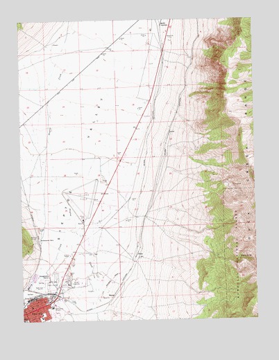
East Ely, NV USGS Topographic Map
Click on map above to begin viewing in our Map Viewer.

This topographic map contains these locations and features:
Feature Name Type Latitude Longitude GNIS ID View Map
Baltimore MillPopulated PlaceN39.2844°W114.8689°858806View Map
City of ElyCivilN39.2649°W114.8709°2410435View Map
David E Norman Elementary SchoolSchoolN39.2513°W114.8656°862947View Map
Drive Inn TheatreLocaleN39.2772°W114.8511°862588View Map
Duck Creek RangeRangeN39.3274°W114.7567°859595View Map
Early Childhood CenterSchoolN39.2581°W114.8676°2095131View Map
East ElyPopulated PlaceN39.2549°W114.8692°859617View Map
East Ely Station Post OfficePost OfficeN39.2569°W114.8681°864741View Map
Ely Airport /Yelland FieldAirportN39.3003°W114.8351°864051View Map
Ely TownshipCivilN39.2938°W114.8717°857650View Map
Ely Warm SpringsSpringN39.2619°W114.8700°857075View Map
Georgetown RanchLocaleN39.2686°W114.8620°859814View Map
HilineLocaleN39.2763°W114.8158°859995View Map
Huesser Winter WellWellN39.3280°W114.8325°862847View Map
KELY-AM (Ely)TowerN39.2624°W114.8636°865036View Map
Lackawanna SpringsSpringN39.2836°W114.8664°860287View Map
Lackawanna Volunteer Fire DepartmentBuildingN39.3371°W114.8682°2581324View Map
LavonPopulated PlaceN39.3277°W114.7967°860307View Map
Lead King MineMineN39.3744°W114.7692°852834View Map
McGill JunctionPopulated PlaceN39.3722°W114.8011°860525View Map
MosierPopulated PlaceN39.2605°W114.8270°860651View Map
Murry CreekStreamN39.3088°W114.8595°860698View Map
Nevada Highway Patrol Northern Command East Ely SubstationBuildingN39.2643°W114.8547°2740072View Map
Prince Shopping CenterLocaleN39.2555°W114.8672°862905View Map
Steptoe SpringSpringN39.2754°W114.7588°861584View Map
Warm SpringSpringN39.2913°W114.8642°862844View Map
White Pine Care CenterHospitalN39.2570°W114.8611°2076220View Map
White Pine County Emergency Medical Services and Fire Rescue Station 1BuildingN39.2919°W114.8374°2581331View Map
White Pine Golf CourseLocaleN39.2658°W114.8606°861971View Map
William Bee Ririe Critical Access HospitalHospitalN39.2557°W114.8594°861586View Map

Note: Coordinates in the location and feature list above are referenced to NAD83 datum.


Copyright (C) 2008-2024 Ryan Niemi / Sunset Dynamics ... All Rights Reserved