TopoQuest Logo
Do you find TopoQuest useful?
Help keep TopoQuest running and adding new maps/features by donating!
Bitcoin:  19c7KJd3qBynnjoSw5npx9KScwjBe4ifkT
Litecoin:  LXs6TkuXGGXo1vDsWCkWVdjQX94eUKd6ui
Home View Maps Find Maps Find Places Resources & Links


Edward, North Carolina Topographic Map

USGS Map Title: Edward, NC
USGS Map MRC: 35076C8
DRG (GeoTIFF) Download: o35076c8.tif


Neighboring USGS Topographic Map Quads:


  Hackney, NC  
35077D1
 

  Blounts Bay, NC  
35076D8
 

  Bath, NC  
35076D7
 

  Ernul, NC  
35077C1
 

  Edward, NC  
35076C8
 

  Aurora, NC  
35076C7
 

  Askin, NC  
35077B1
 

  Reelsboro, NC  
35076B8
 

  Bayboro, NC  
35076B7


Map MRC Location:

N36°
W77°
N36°
W76°
H8 H7 H6 H5 H4 H3 H2 H1
G8 G7 G6 G5 G4 G3 G2 G1
F8 F7 F6 F5 F4 F3 F2 F1
E8 E7 E6 E5 E4 E3 E2 E1
D8 D7 D6 D5 D4 D3 D2 D1
C8 C7 C6 C5 C4 C3 C2 C1
B8 B7 B6 B5 B4 B3 B2 B1
A8 A7 A6 A5 A4 A3 A2 A1
N35°
W77°
N35°
W76°

Edward, NC USGS 1:24K Topographic Map Preview:
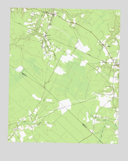
Edward, NC USGS Topographic Map
Click on map above to begin viewing in our Map Viewer.

This topographic map contains these locations and features:
Feature Name Type Latitude Longitude GNIS ID View Map
Aurora Fire Department Edward SubstationBuildingN35.3263°W76.8881°2638149View Map
Blounts CreekPopulated PlaceN35.3499°W76.9599°1019223View Map
Blounts Creek Post OfficePost OfficeN35.3695°W76.9531°2773880View Map
Blounts Creek Volunteer Fire Department and Emergency Medical ServicesBuildingN35.3701°W76.9492°2638781View Map
Bushy ForkStreamN35.2688°W76.9716°982323View Map
CaytonPopulated PlaceN35.2638°W76.9897°1019567View Map
Coxs CrossroadsPopulated PlaceN35.3699°W76.9522°1019830View Map
EdwardPopulated PlaceN35.3243°W76.8752°1020113View Map
Edward Post OfficePost OfficeN35.3261°W76.8817°2773866View Map
EgyptPopulated PlaceN35.3160°W76.9497°1008129View Map
Jones StorePopulated PlaceN35.3096°W76.9541°1008134View Map
Little Swift Creek Volunteer Fire DepartmentBuildingN35.2560°W76.9948°2638505View Map
New Haven ChurchChurchN35.2616°W76.9899°990971View Map
Phennia ChapelChurchN35.3413°W76.8886°992119View Map
Poundpole Swamp BranchStreamN35.3527°W76.9702°992762View Map
Saint Anna ChurchChurchN35.3460°W76.9566°993866View Map
Saint Luke ChurchChurchN35.3277°W76.8819°993983View Map
Smyrna ChurchChurchN35.3599°W76.9563°995029View Map
StilleyPopulated PlaceN35.3388°W76.9255°1022793View Map
Triumph ChurchChurchN35.3379°W76.9636°996263View Map
Warren ChapelChurchN35.3710°W76.9574°996800View Map

Note: Coordinates in the location and feature list above are referenced to NAD83 datum.


Copyright (C) 2008-2025 Ryan Niemi / Sunset Dynamics ... All Rights Reserved