TopoQuest Logo
Do you find TopoQuest useful?
Help keep TopoQuest running and adding new maps/features by donating!
Bitcoin:  19c7KJd3qBynnjoSw5npx9KScwjBe4ifkT
Litecoin:  LXs6TkuXGGXo1vDsWCkWVdjQX94eUKd6ui
Home View Maps Find Maps Find Places Resources & Links


Bayboro, North Carolina Topographic Map

USGS Map Title: Bayboro, NC
USGS Map MRC: 35076B7
DRG (GeoTIFF) Download: o35076b7.tif


Neighboring USGS Topographic Map Quads:


  Edward, NC  
35076C8
 

  Aurora, NC  
35076C7
 

  South Creek, NC  
35076C6
 

  Reelsboro, NC  
35076B8
 

  Bayboro, NC  
35076B7
 

  Vandemere, NC  
35076B6
 

  Upper Broad Creek, NC  
35076A8
 

  Arapahoe, NC  
35076A7
 

  Oriental, NC  
35076A6


Map MRC Location:

N36°
W77°
N36°
W76°
H8 H7 H6 H5 H4 H3 H2 H1
G8 G7 G6 G5 G4 G3 G2 G1
F8 F7 F6 F5 F4 F3 F2 F1
E8 E7 E6 E5 E4 E3 E2 E1
D8 D7 D6 D5 D4 D3 D2 D1
C8 C7 C6 C5 C4 C3 C2 C1
B8 B7 B6 B5 B4 B3 B2 B1
A8 A7 A6 A5 A4 A3 A2 A1
N35°
W77°
N35°
W76°

Bayboro, NC USGS 1:24K Topographic Map Preview:
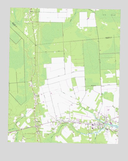
Bayboro, NC USGS Topographic Map
Click on map above to begin viewing in our Map Viewer.

This topographic map contains these locations and features:
Feature Name Type Latitude Longitude GNIS ID View Map
A CanalCanalN35.2013°W76.7905°980009View Map
AlliancePopulated PlaceN35.1449°W76.8022°1018801View Map
Alliance Post OfficePost OfficeN35.1446°W76.8030°2505321View Map
B CanalCanalN35.1966°W76.7716°980400View Map
Bay CityPopulated PlaceN35.1793°W76.7705°1006124View Map
BayboroPopulated PlaceN35.1429°W76.7702°1024752View Map
Bayboro Post OfficePost OfficeN35.1425°W76.7695°2505330View Map
Bonner CanalCanalN35.1896°W76.8080°981719View Map
Britthaven of PamlicoBuildingN35.1401°W76.8237°2505747View Map
C CanalCanalN35.1985°W76.7541°982373View Map
Central SchoolSchoolN35.1385°W76.7624°982967View Map
East Fork Goose GreekStreamN35.1377°W76.8666°984502View Map
Flowers CanalCanalN35.1743°W76.8013°985238View Map
Fred A Anderson Elementary SchoolSchoolN35.1426°W76.7804°1003163View Map
GrantsboroPopulated PlaceN35.1404°W76.8424°1020496View Map
Grantsboro - Silverhill Volunteer Fire Department and Emergency ServicesBuildingN35.1400°W76.8421°2638266View Map
Grantsboro Post OfficePost OfficeN35.1398°W76.8453°2505369View Map
Green Hill ChurchChurchN35.1499°W76.7652°986060View Map
Keys CanalCanalN35.1799°W76.7883°987947View Map
Neal CreekStreamN35.1352°W76.7741°990884View Map
North Prong Bay RiverStreamN35.1435°W76.7627°991256View Map
Pamlico AirportAirportN35.1524°W76.7626°1003167View Map
Pamlico Correctional InstitutionBuildingN35.1602°W76.7710°2505315View Map
Pamlico County Sheriff's OfficeBuildingN35.1436°W76.7701°2130986View Map
Pamlico High SchoolSchoolN35.1429°W76.7794°1003165View Map
Pamlico Rescue SquadBuildingN35.1421°W76.7819°2720653View Map
PrescottPopulated PlaceN35.2466°W76.8522°1022072View Map
Rock of Zion ChurchChurchN35.1352°W76.8408°993478View Map
Saint Marks ChurchChurchN35.1491°W76.7635°994010View Map
SandhillLocaleN35.1604°W76.8444°1003166View Map
Sandhill CanalCanalN35.1629°W76.8333°994247View Map
Sawyer CanalCanalN35.1702°W76.8083°994398View Map
Silver HillPopulated PlaceN35.1691°W76.8452°994814View Map
South Prong Bay RiverStreamN35.1435°W76.7627°995191View Map
Town of AllianceCivilN35.1435°W76.8085°2405137View Map
Town of BayboroCivilN35.1475°W76.7692°2405218View Map
Town of GrantsboroCivilN35.1449°W76.8447°2406604View Map
Township 3CivilN35.1635°W76.7943°1027020View Map
Triangle Volunteer Fire DepartmentBuildingN35.1446°W76.7737°2638236View Map
West Alliance Station (historical)LocaleN35.1446°W76.8024°1952094View Map
West Branch ChurchChurchN35.1427°W76.7835°996990View Map
West Fork Goose CreekStreamN35.1377°W76.8663°997015View Map
Whitehurst CreekCanalN35.1802°W76.7588°997228View Map

Note: Coordinates in the location and feature list above are referenced to NAD83 datum.


Copyright (C) 2008-2025 Ryan Niemi / Sunset Dynamics ... All Rights Reserved