TopoQuest Logo
Do you find TopoQuest useful?
Help keep TopoQuest running and adding new maps/features by donating!
Bitcoin:  19c7KJd3qBynnjoSw5npx9KScwjBe4ifkT
Litecoin:  LXs6TkuXGGXo1vDsWCkWVdjQX94eUKd6ui
Home View Maps Find Maps Find Places Resources & Links


Egg Harbor, Wisconsin Topographic Map

USGS Map Title: Egg Harbor, WI
USGS Map MRC: 45087A3
DRG (GeoTIFF) Download: o45087a3.tif


Neighboring USGS Topographic Map Quads:


  Chambers Island NW, WI  
45087B4
 

  Chambers Island, WI  
45087B3
 

  Ephraim, WI  
45087B2
 

  Green Island, WI  
45087A4
 

  Egg Harbor, WI  
45087A3
 

  Baileys Harbor West, WI  
45087A2
 

  Idlewild, WI  
44087H4
 

  Institute, WI  
44087H3
 

  Jacksonport, WI  
44087H2


Map MRC Location:

N46°
W88°
N46°
W87°
H8 H7 H6 H5 H4 H3 H2 H1
G8 G7 G6 G5 G4 G3 G2 G1
F8 F7 F6 F5 F4 F3 F2 F1
E8 E7 E6 E5 E4 E3 E2 E1
D8 D7 D6 D5 D4 D3 D2 D1
C8 C7 C6 C5 C4 C3 C2 C1
B8 B7 B6 B5 B4 B3 B2 B1
A8 A7 A6 A5 A4 A3 A2 A1
N45°
W88°
N45°
W87°

Egg Harbor, WI USGS 1:24K Topographic Map Preview:
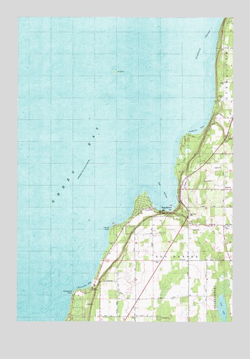
Egg Harbor, WI USGS Topographic Map
Click on map above to begin viewing in our Map Viewer.

This topographic map contains these locations and features:
Feature Name Type Latitude Longitude GNIS ID View Map
Alpine Country ClubLocaleN45.0464°W87.2965°1577988View Map
Door County Library Egg Harbor BranchBuildingN45.0528°W87.2797°2711348View Map
Egg HarborBayN45.0547°W87.2909°1564459View Map
Egg HarborPopulated PlaceN45.0464°W87.2971°1564460View Map
Egg Harbor CemeteryCemeteryN45.0441°W87.2754°1577989View Map
Egg Harbor Volunteer Fire Department Station 1BuildingN45.0474°W87.2751°2697985View Map
Egg Harbor Wastewater Treatment PlantLocaleN45.0433°W87.2714°2709433View Map
Evangelical ChurchChurchN45.0550°W87.2790°1564722View Map
Hat IslandIslandN45.1022°W87.3179°1566123View Map
Hillcrest OrchardLocaleN45.0594°W87.2539°2711252View Map
Horseshoe BayBayN45.0153°W87.3365°1566719View Map
Horseshoe PointCapeN45.0119°W87.3409°1566748View Map
Juddville BayBayN45.0783°W87.2712°1567304View Map
Juddville CemeteryCemeteryN45.0928°W87.2557°1577990View Map
Leroys PointCapeN45.0375°W87.3198°1567989View Map
Lost LakeLakeN45.0053°W87.2558°1568682View Map
Murphy County ParkParkN45.0142°W87.3329°1577987View Map
Orchards Golf CourseLocaleN45.0636°W87.2583°2711255View Map
Saint Johns CemeteryCemeteryN45.0248°W87.2924°1573067View Map
School Number OneSchoolN45.0472°W87.2746°1573805View Map
Sunny Point SchoolSchoolN45.0055°W87.3073°1575087View Map
Sunnypoint GardensLocaleN45.0067°W87.3089°2711257View Map
Tanck Family DairyLocaleN45.0383°W87.2508°2711250View Map
Town of Egg HarborCivilN45.0165°W87.3714°1583137View Map
Upper Lost LakeLakeN45.0183°W87.2560°2761479View Map
Village of Egg HarborCivilN45.0565°W87.2959°1583136View Map
White Cliff Fen And Forest State Natural AreaParkN45.0708°W87.2761°2085439View Map

Note: Coordinates in the location and feature list above are referenced to NAD83 datum.


Copyright (C) 2008-2024 Ryan Niemi / Sunset Dynamics ... All Rights Reserved