TopoQuest Logo
Do you find TopoQuest useful?
Help keep TopoQuest running and adding new maps/features by donating!
Bitcoin:  19c7KJd3qBynnjoSw5npx9KScwjBe4ifkT
Litecoin:  LXs6TkuXGGXo1vDsWCkWVdjQX94eUKd6ui
Home View Maps Find Maps Find Places Resources & Links


Ephraim, Wisconsin Topographic Map

USGS Map Title: Ephraim, WI
USGS Map MRC: 45087B2
DRG (GeoTIFF) Download: o45087b2.tif


Neighboring USGS Topographic Map Quads:


  Ellison Bay, WI  
45087C1
 

  Chambers Island, WI  
45087B3
 

  Ephraim, WI  
45087B2
 

  Sister Bay, WI  
45087B1
 

  Egg Harbor, WI  
45087A3
 

  Baileys Harbor West, WI  
45087A2
 

  Baileys Harbor East, WI  
45087A1


Map MRC Location:

N46°
W88°
N46°
W87°
H8 H7 H6 H5 H4 H3 H2 H1
G8 G7 G6 G5 G4 G3 G2 G1
F8 F7 F6 F5 F4 F3 F2 F1
E8 E7 E6 E5 E4 E3 E2 E1
D8 D7 D6 D5 D4 D3 D2 D1
C8 C7 C6 C5 C4 C3 C2 C1
B8 B7 B6 B5 B4 B3 B2 B1
A8 A7 A6 A5 A4 A3 A2 A1
N45°
W88°
N45°
W87°

Ephraim, WI USGS 1:24K Topographic Map Preview:
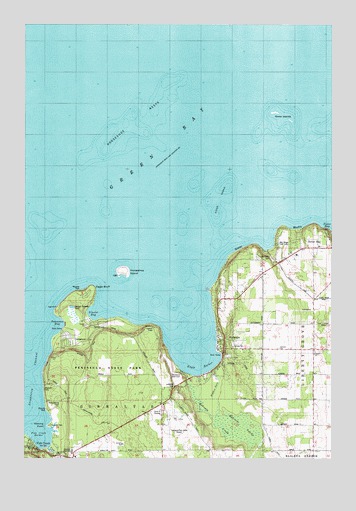
Ephraim, WI USGS Topographic Map
Click on map above to begin viewing in our Map Viewer.

This topographic map contains these locations and features:
Feature Name Type Latitude Longitude GNIS ID View Map
Bay Ridge Golf ClubLocaleN45.1867°W87.1448°1577952View Map
Bethany Lutheran CemeteryCemeteryN45.1459°W87.1893°1577943View Map
Blossomberg CemeteryCemeteryN45.1420°W87.2357°1577945View Map
Door County Library Ephraim BranchBuildingN45.1561°W87.1711°2711349View Map
Door County Library Fish Creek BranchBuildingN45.1264°W87.2417°2711358View Map
Eagle BluffCliffN45.1742°W87.2219°1564234View Map
Eagle Bluff LightBuildingN45.1705°W87.2251°1577944View Map
Eagle HarborBayN45.1567°W87.1826°1564240View Map
EphraimPopulated PlaceN45.1564°W87.1682°1564680View Map
Ephraim CreekStreamN45.1486°W87.1807°1577374View Map
Ephraim Fire DepartmentBuildingN45.1575°W87.1652°2698030View Map
Ephraim Post OfficePost OfficeN45.1575°W87.1697°2711344View Map
Ephraim SwampSwampN45.1342°W87.1609°1564681View Map
Ephraim Wastewater Treatment PlantLocaleN45.1703°W87.1542°2709432View Map
Ephraim Yacht Harbor, IncorporatedLocaleN45.1603°W87.1712°1577948View Map
Ephraim-Gibraltar AirportAirportN45.1369°W87.1858°1578055View Map
Fish CreekPopulated PlaceN45.1278°W87.2471°1564983View Map
Fish CreekStreamN45.1278°W87.2404°1564987View Map
Fish Creek HarborBayN45.1292°W87.2446°1577224View Map
Gibraltar Elementary SchoolSchoolN45.1265°W87.2307°2716742View Map
Gibraltar Secondary SchoolSchoolN45.1272°W87.2307°1577939View Map
Gibraltar Secondary SchoolSchoolN45.1272°W87.2307°2716326View Map
Hidden Springs CreekStreamN45.1514°W87.1723°1577305View Map
Horseshoe IslandIslandN45.1789°W87.2093°1566724View Map
Horseshoe ReefsBarN45.2211°W87.2076°1566750View Map
Little Sister CemeteryCemeteryN45.1825°W87.1494°1568416View Map
Nicolet BayBayN45.1669°W87.2201°1573966View Map
Peninsula Park Beech Forest State Natural AreaParkN45.1572°W87.1983°2085431View Map
Peninsula Park White Cedar Forest State Natural AreaParkN45.1353°W87.2342°2085432View Map
Peninsula State ParkParkN45.1469°W87.2143°1571174View Map
Penninsula Golf ClubLocaleN45.1494°W87.1909°1577949View Map
Pioneer SchoolSchoolN45.1564°W87.1654°1577953View Map
Settlement SchoolSchoolN45.1497°W87.1318°1573907View Map
Sister BluffsCliffN45.1861°W87.1540°1574210View Map
Sister IslandsIslandN45.2244°W87.1462°1574211View Map
Sister Islands State Natural AreaParkN45.2236°W87.1450°2085434View Map
Sister ShoalsBarN45.2003°W87.1696°1574213View Map
Skyway Drive-InLocaleN45.1378°W87.1981°2634414View Map
Svens BluffCliffN45.1342°W87.2323°1840256View Map
Tennison BayBayN45.1639°W87.2354°1575310View Map
Village of EphraimCivilN45.1663°W87.1725°1583170View Map
Village of Sister BayCivilN45.1867°W87.1296°1584166View Map
Weborg PointCapeN45.1344°W87.2393°1576380View Map

Note: Coordinates in the location and feature list above are referenced to NAD83 datum.


Copyright (C) 2008-2024 Ryan Niemi / Sunset Dynamics ... All Rights Reserved