TopoQuest Logo
Do you find TopoQuest useful?
Help keep TopoQuest running and adding new maps/features by donating!
Bitcoin:  19c7KJd3qBynnjoSw5npx9KScwjBe4ifkT
Litecoin:  LXs6TkuXGGXo1vDsWCkWVdjQX94eUKd6ui
Home View Maps Find Maps Find Places Resources & Links


Arena, New York Topographic Map

USGS Map Title: Arena, NY
USGS Map MRC: 42074A6
DRG (GeoTIFF) Download: o42074a6.tif


Neighboring USGS Topographic Map Quads:


  Andes, NY  
42074B7
 

  Margaretville, NY  
42074B6
 

  Fleischmanns, NY  
42074B5
 

  Lewbeach, NY  
42074A7
 

  Arena, NY  
42074A6
 

  Seager, NY  
42074A5
 

  Livingston Manor, NY  
41074H7
 

  Willowemoc, NY  
41074H6
 

  Claryville, NY  
41074H5


Map MRC Location:

N43°
W75°
N43°
W74°
H8 H7 H6 H5 H4 H3 H2 H1
G8 G7 G6 G5 G4 G3 G2 G1
F8 F7 F6 F5 F4 F3 F2 F1
E8 E7 E6 E5 E4 E3 E2 E1
D8 D7 D6 D5 D4 D3 D2 D1
C8 C7 C6 C5 C4 C3 C2 C1
B8 B7 B6 B5 B4 B3 B2 B1
A8 A7 A6 A5 A4 A3 A2 A1
N42°
W75°
N42°
W74°

Arena, NY USGS 1:24K Topographic Map Preview:
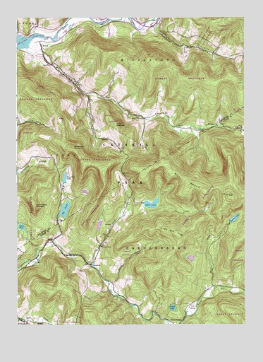
Arena, NY USGS Topographic Map
Click on map above to begin viewing in our Map Viewer.

This topographic map contains these locations and features:
Feature Name Type Latitude Longitude GNIS ID View Map
Advent Christian ChurchChurchN42.1123°W74.7366°2492190View Map
Alder CreekStreamN42.0254°W74.7090°942277View Map
Alder LakeLakeN42.0492°W74.6763°942288View Map
ArenaPopulated PlaceN42.1156°W74.7374°942547View Map
Arena Fire DepartmentBuildingN42.0925°W74.6985°2718249View Map
Banks - Eighmy CemeteryCemeteryN42.0322°W74.7036°2559442View Map
Barkaboom MountainSummitN42.0718°W74.7202°943007View Map
Beaverkill Trout HatcheryLocaleN42.0258°W74.7078°2555042View Map
Beecher BrookStreamN42.0151°W74.6418°943526View Map
Beecher LakeReservoirN42.0430°W74.6309°943528View Map
Big PondReservoirN42.0469°W74.7238°943941View Map
Cold Spring HollowValleyN42.1217°W74.6751°947076View Map
Cradle Rock RidgeRidgeN42.0373°W74.6629°947631View Map
Cross MountainSummitN42.0809°W74.6957°947806View Map
Forest LakeLakeN42.0068°W74.6647°950408View Map
Grant MillsPopulated PlaceN42.0843°W74.6804°951517View Map
Grants Mills Covered BridgeBridgeN42.0806°W74.6364°2097329View Map
HardenburgPopulated PlaceN42.0009°W74.6652°972595View Map
Huckleberry BrookStreamN42.1240°W74.6738°970224View Map
Little PondLakeN42.0398°W74.7471°955637View Map
Mill BrookStreamN42.1162°W74.7460°957202View Map
Mill Brook RidgeRidgeN42.0543°W74.6468°957209View Map
Mountain LakeReservoirN42.0597°W74.7238°957948View Map
Old Stone SchoolSchoolN42.1226°W74.6757°959326View Map
Old Stone School (historical)SchoolN42.1225°W74.6744°2096637View Map
School Number 8 (historical)SchoolN42.0318°W74.7035°975578View Map
Scudder BrookStreamN42.0168°W74.6996°964711View Map
Touchmenot MountainSummitN42.0481°W74.7407°967685View Map
TurnwoodPopulated PlaceN42.0243°W74.7090°973168View Map
Tuscarora Club BridgeBridgeN42.0901°W74.6942°2419923View Map

Note: Coordinates in the location and feature list above are referenced to NAD83 datum.


Copyright (C) 2008-2024 Ryan Niemi / Sunset Dynamics ... All Rights Reserved