TopoQuest Logo
Do you find TopoQuest useful?
Help keep TopoQuest running and adding new maps/features by donating!
Bitcoin:  19c7KJd3qBynnjoSw5npx9KScwjBe4ifkT
Litecoin:  LXs6TkuXGGXo1vDsWCkWVdjQX94eUKd6ui
Home View Maps Find Maps Find Places Resources & Links


Arendtsville, Pennsylvania Topographic Map

USGS Map Title: Arendtsville, PA
USGS Map MRC: 39077H3
DRG (GeoTIFF) Download: o39077h3.tif


Neighboring USGS Topographic Map Quads:


  Walnut Bottom, PA  
40077A4
 

  Dickinson, PA  
40077A3
 

  Mount Holly Springs, PA  
40077A2
 

  Caledonia Park, PA  
39077H4
 

  Arendtsville, PA  
39077H3
 

  Biglerville, PA  
39077H2
 

  Iron Springs, PA  
39077G4
 

  Fairfield, PA  
39077G3
 

  Gettysburg, PA  
39077G2


Map MRC Location:

N40°
W78°
N40°
W77°
H8 H7 H6 H5 H4 H3 H2 H1
G8 G7 G6 G5 G4 G3 G2 G1
F8 F7 F6 F5 F4 F3 F2 F1
E8 E7 E6 E5 E4 E3 E2 E1
D8 D7 D6 D5 D4 D3 D2 D1
C8 C7 C6 C5 C4 C3 C2 C1
B8 B7 B6 B5 B4 B3 B2 B1
A8 A7 A6 A5 A4 A3 A2 A1
N39°
W78°
N39°
W77°

Arendtsville, PA USGS 1:24K Topographic Map Preview:
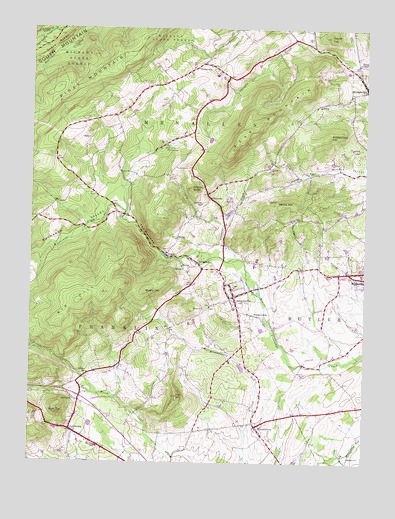
Arendtsville, PA USGS Topographic Map
Click on map above to begin viewing in our Map Viewer.

This topographic map contains these locations and features:
Feature Name Type Latitude Longitude GNIS ID View Map
ArendtsvillePopulated PlaceN39.9231°W77.2986°1168383View Map
Arendtsville Community Fire Company Station 5BuildingN39.9245°W77.2997°2099991View Map
Arendtsville Elementary SchoolSchoolN39.9260°W77.2980°1211560View Map
Arendtsville Post OfficePost OfficeN39.9215°W77.2995°2756650View Map
Arendtsville Vocational School Community CenterBuildingN39.9198°W77.2976°2100239View Map
Bear MountainSummitN39.9654°W77.2992°1168891View Map
BeechersvillePopulated PlaceN39.9173°W77.2894°1169115View Map
Bendersville CemeteryCemeteryN39.9815°W77.2519°2774886View Map
Big HillSummitN39.9215°W77.3567°1169514View Map
Biglerville CemeteryCemeteryN39.9336°W77.2516°2774917View Map
Biglerville Post OfficePost OfficeN39.9301°W77.2509°2756653View Map
Borough of ArendtsvilleCivilN39.9234°W77.2999°1214751View Map
BridgeportPopulated PlaceN39.9323°W77.3117°1170236View Map
BrysoniaPopulated PlaceN39.9515°W77.3078°1170493View Map
Brysonia SchoolSchoolN39.9498°W77.3108°1170494View Map
Buchanan ValleyValleyN39.9488°W77.3462°1170504View Map
Bushy HillSummitN39.9245°W77.3319°1170778View Map
Camp NawakwaLocaleN39.9654°W77.3242°1171062View Map
CashtownPopulated PlaceN39.8845°W77.3594°1171306View Map
Cashtown Census Designated PlaceCensusN39.8837°W77.3533°2630001View Map
Cashtown Community Fire Department Station 4BuildingN39.8828°W77.3554°2653115View Map
Cashtown Post OfficePost OfficeN39.8848°W77.3588°2756657View Map
Cashtown-McKnightstown Census Designated Place (historical)CensusN39.8786°W77.3446°2389283View Map
Clearspring SchoolSchoolN39.9315°W77.2722°1211084View Map
Eicholtz Mill (historical)LocaleN39.9348°W77.3250°1211269View Map
Fairview CemeteryCemeteryN39.9179°W77.3014°2755361View Map
Flohrs Lutheran Church CemeteryCemeteryN39.8751°W77.3394°2774879View Map
Fox HillSummitN39.8943°W77.3197°1175096View Map
Franklin Township Elementary SchoolSchoolN39.8795°W77.3495°1175167View Map
German Society Lutheran Calvinist CemeteryCemeteryN39.8762°W77.3391°2774881View Map
Grave RidgeRidgeN39.9920°W77.3719°1175999View Map
Greenmount CemeteryCemeteryN39.9201°W77.3024°2508618View Map
HilltownPopulated PlaceN39.8940°W77.3589°1177127View Map
Michaux State ForestForestN39.9904°W77.3586°1192923View Map
Mount Calvary Methodist CemeteryCemeteryN39.9005°W77.3529°2774907View Map
MummasburgPopulated PlaceN39.8856°W77.2894°1182078View Map
Mummasburg Mennonite CemeteryCemeteryN39.8863°W77.2854°2774918View Map
Pinegrove School (historical)SchoolN39.9118°W77.2817°1211085View Map
Pleasant Dale CreekStreamN39.9340°W77.2975°1184005View Map
Rattlesnake HillSummitN39.9693°W77.2644°1184671View Map
Rock TopSummitN39.8893°W77.3642°1193208View Map
Rocky Grove School (historical)SchoolN39.9009°W77.3164°1211086View Map
Round TopSummitN39.9981°W77.2639°1185540View Map
Schulteis AirportAirportN39.9602°W77.2579°1193781View Map
Sheelys SchoolSchoolN39.9009°W77.3528°1187422View Map
The NarrowsGapN39.9404°W77.3319°1189431View Map
Township of MenallenCivilN39.9786°W77.3041°1215789View Map
Tysons HillSummitN39.9668°W77.2525°1190059View Map
Wenks Post OfficePost OfficeN39.9901°W77.3114°1214270View Map
WenksvillePopulated PlaceN39.9901°W77.3105°1190830View Map
Wenksville CemeteryCemeteryN39.9900°W77.3075°2774915View Map
Wildcat KnobSummitN39.9543°W77.3150°1191415View Map
Yellow HillSummitN39.9495°W77.2805°1191877View Map

Note: Coordinates in the location and feature list above are referenced to NAD83 datum.


Copyright (C) 2008-2025 Ryan Niemi / Sunset Dynamics ... All Rights Reserved