TopoQuest Logo
Do you find TopoQuest useful?
Help keep TopoQuest running and adding new maps/features by donating!
Bitcoin:  19c7KJd3qBynnjoSw5npx9KScwjBe4ifkT
Litecoin:  LXs6TkuXGGXo1vDsWCkWVdjQX94eUKd6ui
Home View Maps Find Maps Find Places Resources & Links


Mount Holly Springs, Pennsylvania Topographic Map

USGS Map Title: Mount Holly Springs, PA
USGS Map MRC: 40077A2
DRG (GeoTIFF) Download: o40077a2.tif


Neighboring USGS Topographic Map Quads:


  Plainfield, PA  
40077B3
 

  Carlisle, PA  
40077B2
 

  Mechanicsburg, PA  
40077B1
 

  Dickinson, PA  
40077A3
 

  Mount Holly Springs, PA  
40077A2
 

  Dillsburg, PA  
40077A1
 

  Arendtsville, PA  
39077H3
 

  Biglerville, PA  
39077H2
 

  Hampton, PA  
39077H1


Map MRC Location:

N41°
W78°
N41°
W77°
H8 H7 H6 H5 H4 H3 H2 H1
G8 G7 G6 G5 G4 G3 G2 G1
F8 F7 F6 F5 F4 F3 F2 F1
E8 E7 E6 E5 E4 E3 E2 E1
D8 D7 D6 D5 D4 D3 D2 D1
C8 C7 C6 C5 C4 C3 C2 C1
B8 B7 B6 B5 B4 B3 B2 B1
A8 A7 A6 A5 A4 A3 A2 A1
N40°
W78°
N40°
W77°

Mount Holly Springs, PA USGS 1:24K Topographic Map Preview:
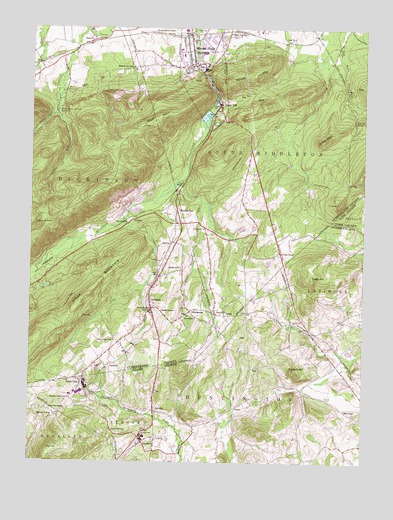
Mount Holly Springs, PA USGS Topographic Map
Click on map above to begin viewing in our Map Viewer.

This topographic map contains these locations and features:
Feature Name Type Latitude Longitude GNIS ID View Map
BarnitzPopulated PlaceN40.1215°W77.2264°1168749View Map
Beetems ChurchChurchN40.0690°W77.2125°1211133View Map
Big HillSummitN40.0045°W77.2403°1169515View Map
Borough of Mount Holly SpringsCivilN40.1126°W77.1854°1215150View Map
Carlisle JunctionLocaleN40.1243°W77.1766°1195889View Map
Carlisle JunctionPopulated PlaceN40.1243°W77.1766°1205032View Map
Chestnut Ridge SchoolSchoolN40.0351°W77.2175°1171750View Map
Citizens Fire Company Holly Station 36BuildingN40.1164°W77.1903°2652646View Map
Cold Spring RunStreamN40.1243°W77.2291°1172161View Map
Fickels HillSummitN40.0534°W77.1444°1174727View Map
GardnersPopulated PlaceN40.0056°W77.2069°1175444View Map
Gardners Census Designated PlaceCensusN40.0064°W77.2083°2634230View Map
Gardners Post OfficePost OfficeN40.0059°W77.2066°2756641View Map
GargolPopulated PlaceN40.0159°W77.1728°1203654View Map
GoodyearPopulated PlaceN40.0465°W77.2047°1175823View Map
Goodyear CemeteryCemeteryN40.0433°W77.2012°1175824View Map
Hammonds RocksSummitN40.0681°W77.2486°1176439View Map
Highlands Farm DamDamN40.0484°W77.1497°1194513View Map
Hunters RunPopulated PlaceN40.0720°W77.1953°1192648View Map
Hunters RunStreamN40.0812°W77.1933°1177616View Map
IdavillePopulated PlaceN40.0148°W77.2028°1177683View Map
Idaville Census Designated PlaceCensusN40.0199°W77.2034°2634233View Map
Idaville United Methodist CemeteryCemeteryN40.0204°W77.2020°2774894View Map
Keller HillSummitN40.1118°W77.1653°1178318View Map
Millers SchoolSchoolN40.0154°W77.1314°1181251View Map
Mount HollySummitN40.0979°W77.2030°1192622View Map
Mount Holly Spring Elementary SchoolSchoolN40.1168°W77.1905°1211561View Map
Mount Holly SpringsPopulated PlaceN40.1184°W77.1900°1181701View Map
Mount Holly Springs CemeteryCemeteryN40.1242°W77.1955°1181702View Map
Mount Holly Springs LakeReservoirN40.0994°W77.1845°1194532View Map
Mount Holly Springs Police DepartmentBuildingN40.1160°W77.1919°2754597View Map
Mount Holly Springs Post OfficePost OfficeN40.1143°W77.1903°2772849View Map
Mount Holly Springs ReservoirReservoirN40.1009°W77.2400°1181703View Map
Mount TaborPopulated PlaceN40.0134°W77.2394°1181852View Map
Mount Tabor CemeteryCemeteryN40.0156°W77.2424°1181854View Map
Mount Victory ChurchChurchN40.0606°W77.1561°1181881View Map
Mount Zion ChurchChurchN40.0443°W77.2044°1181914View Map
Mountain View SchoolSchoolN40.0184°W77.2347°1192982View Map
Mountain View SchoolSchoolN40.1137°W77.2119°1192983View Map
MyerstownPopulated PlaceN40.0437°W77.1894°1182137View Map
Peach GlenPopulated PlaceN40.0231°W77.2300°1183418View Map
Pike SchoolSchoolN40.0709°W77.1603°1211131View Map
Pike SchoolSchoolN40.0376°W77.1436°1211132View Map
Pine SchoolSchoolN40.0676°W77.1850°1183905View Map
Pleasant Acre FarmsLocaleN40.0264°W77.1364°2709799View Map
Red TankLocaleN40.1215°W77.1544°1184799View Map
Rockeys SchoolSchoolN40.0556°W77.1930°1185307View Map
Rocky RidgeRidgeN40.0931°W77.1394°1185359View Map
Sadler SchoolSchoolN40.0281°W77.1603°1211130View Map
Snyders HillSummitN40.0268°W77.1514°1198302View Map
Spruce RunStreamN40.1001°W77.2403°1188341View Map
Spruce Run VistaLocaleN40.0787°W77.2194°1206245View Map
StarnersPopulated PlaceN40.0270°W77.2205°1204721View Map
Tagg RunStreamN40.0701°W77.2147°1189235View Map
Tagg Run SchoolSchoolN40.0684°W77.2133°1189236View Map
The PeakSummitN40.0748°W77.1341°1189441View Map
TolandPopulated PlaceN40.0698°W77.2119°1189624View Map
Township of DickinsonCivilN40.1008°W77.2468°1216332View Map
Upper MillPopulated PlaceN40.1031°W77.1791°1190242View Map
Upper Mount Holly DamDamN40.1010°W77.1827°1194533View Map
UriahPopulated PlaceN40.0423°W77.1764°1190268View Map
Uriah ChurchChurchN40.0429°W77.1797°1190269View Map
Uriah SchoolSchoolN40.0418°W77.1875°1190270View Map
Whiskey SpringSpringN40.0718°W77.1314°1202638View Map
Whisky SpringSpringN40.0984°W77.1286°1191242View Map
Whisky Spring Lean-toBuildingN40.0804°W77.1308°1211129View Map
Wolff Farm DamDamN40.0668°W77.1714°1194520View Map

Note: Coordinates in the location and feature list above are referenced to NAD83 datum.


Copyright (C) 2008-2024 Ryan Niemi / Sunset Dynamics ... All Rights Reserved