TopoQuest Logo
Do you find TopoQuest useful?
Help keep TopoQuest running and adding new maps/features by donating!
Bitcoin:  19c7KJd3qBynnjoSw5npx9KScwjBe4ifkT
Litecoin:  LXs6TkuXGGXo1vDsWCkWVdjQX94eUKd6ui
Home View Maps Find Maps Find Places Resources & Links


Elba, Idaho Topographic Map

USGS Map Title: Elba, ID
USGS Map MRC: 42113B5
DRG (GeoTIFF) Download: o42113b5.tif


Neighboring USGS Topographic Map Quads:


  Mount Harrison, ID  
42113C6
 

  Connor Ridge, ID  
42113C5
 

  Nibbs Creek, ID  
42113C4
 

  Cache Peak, ID  
42113B6
 

  Elba, ID  
42113B5
 

  Kane Canyon, ID  
42113B4
 

  Almo, ID  
42113A6
 

  Jim Sage Canyon, ID  
42113A5
 

  Chokecherry Canyon, ID  
42113A4


Map MRC Location:

N43°
W114°
N43°
W113°
H8 H7 H6 H5 H4 H3 H2 H1
G8 G7 G6 G5 G4 G3 G2 G1
F8 F7 F6 F5 F4 F3 F2 F1
E8 E7 E6 E5 E4 E3 E2 E1
D8 D7 D6 D5 D4 D3 D2 D1
C8 C7 C6 C5 C4 C3 C2 C1
B8 B7 B6 B5 B4 B3 B2 B1
A8 A7 A6 A5 A4 A3 A2 A1
N42°
W114°
N42°
W113°

Elba, ID USGS 1:24K Topographic Map Preview:
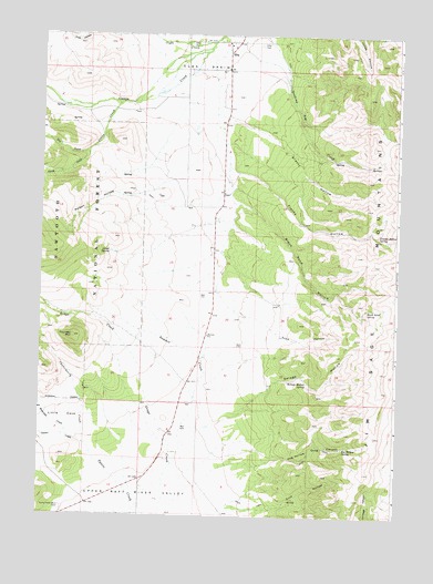
Elba, ID USGS Topographic Map
Click on map above to begin viewing in our Map Viewer.

This topographic map contains these locations and features:
Feature Name Type Latitude Longitude GNIS ID View Map
Black Sand HollowValleyN42.2063°W113.5578°377787View Map
Black Sand SpringSpringN42.1791°W113.5103°377788View Map
Center CreekStreamN42.1435°W113.6095°379128View Map
Chokecherry CreekStreamN42.1435°W113.6095°379323View Map
Cliff HollowValleyN42.1269°W113.5497°379431View Map
Clyde CreekStreamN42.2480°W113.5664°379456View Map
Cross CreekStreamN42.2324°W113.5975°380096View Map
Dry CreekStreamN42.2199°W113.6095°380813View Map
Echo HollowValleyN42.1830°W113.5631°381238View Map
ElbaPopulated PlaceN42.2482°W113.5614°397683View Map
Elba CemeteryCemeteryN42.2477°W113.5493°381294View Map
Elba ParkParkN42.2477°W113.5747°381295View Map
Franks HollowValleyN42.2149°W113.5592°382020View Map
Franks Hollow SpringSpringN42.1972°W113.5059°382021View Map
Grassy HollowValleyN42.2294°W113.5633°382576View Map
Green CreekStreamN42.2199°W113.6092°382633View Map
Keg Hollow CanyonValleyN42.1388°W113.5542°384119View Map
Keg Hollow SpringSpringN42.1429°W113.5185°384120View Map
Little CoveValleyN42.1460°W113.6120°384786View Map
Lloyd SpringSpringN42.1936°W113.6011°385015View Map
Poison HollowValleyN42.2121°W113.5806°388649View Map
Savage HollowValleyN42.1474°W113.5728°389933View Map
Savage Hollow SpringSpringN42.1599°W113.5311°389934View Map
South CreekStreamN42.1457°W113.6245°390863View Map
Summit CreekStreamN42.1385°W113.5781°391615View Map
Sunny Cedar Rest CemeteryCemeteryN42.1271°W113.6167°391659View Map
Thunder MountainSummitN42.1716°W113.6136°392113View Map
Waterfall CreekStreamN42.1455°W113.6147°392942View Map

Note: Coordinates in the location and feature list above are referenced to NAD83 datum.


Copyright (C) 2008-2025 Ryan Niemi / Sunset Dynamics ... All Rights Reserved