TopoQuest Logo
Do you find TopoQuest useful?
Help keep TopoQuest running and adding new maps/features by donating!
Bitcoin:  19c7KJd3qBynnjoSw5npx9KScwjBe4ifkT
Litecoin:  LXs6TkuXGGXo1vDsWCkWVdjQX94eUKd6ui
Home View Maps Find Maps Find Places Resources & Links


Eldon, Washington Topographic Map

USGS Map Title: Eldon, WA
USGS Map MRC: 47123E1
DRG (GeoTIFF) Download: o47123e1.tif


Neighboring USGS Topographic Map Quads:


  The Brothers, WA  
47123F2
 

  Mount Jupiter, WA  
47123F1
 

  Brinnon, WA  
47122F8
 

  Mount Washington, WA  
47123E2
 

  Eldon, WA  
47123E1
 

  Holly, WA  
47122E8
 

  Hoodsport, WA  
47123D2
 

  Lilliwaup, WA  
47123D1
 

  Lake Wooten, WA  
47122D8


Map MRC Location:

N48°
W124°
N48°
W123°
H8 H7 H6 H5 H4 H3 H2 H1
G8 G7 G6 G5 G4 G3 G2 G1
F8 F7 F6 F5 F4 F3 F2 F1
E8 E7 E6 E5 E4 E3 E2 E1
D8 D7 D6 D5 D4 D3 D2 D1
C8 C7 C6 C5 C4 C3 C2 C1
B8 B7 B6 B5 B4 B3 B2 B1
A8 A7 A6 A5 A4 A3 A2 A1
N47°
W124°
N47°
W123°

Eldon, WA USGS 1:24K Topographic Map Preview:
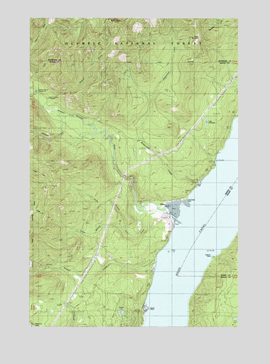
Eldon, WA USGS Topographic Map
Click on map above to begin viewing in our Map Viewer.

This topographic map contains these locations and features:
Feature Name Type Latitude Longitude GNIS ID View Map
AyockPopulated PlaceN47.5073°W123.0568°1531707View Map
Ayock PointCapeN47.5073°W123.0546°1515998View Map
Capstan RockPillarN47.5004°W123.0327°1531702View Map
Chinom PointCapeN47.5284°W123.0174°1517723View Map
Cummings PointCapeN47.5518°W123.0318°1518412View Map
EldonPopulated PlaceN47.5454°W123.0460°1519237View Map
Hamma HammaPopulated PlaceN47.5268°W123.0513°1530542View Map
Hamma Hamma CampgroundLocaleN47.5954°W123.1229°1528967View Map
Hamma Hamma Forest Service StationLocaleN47.5926°W123.1143°1520485View Map
Hamma Hamma RiverStreamN47.5456°W123.0415°1531459View Map
Jefferson CreekStreamN47.5856°W123.1038°1521347View Map
John Ahl SchoolSchoolN47.5509°W123.0343°1521401View Map
John CreekStreamN47.5470°W123.0596°1521404View Map
Jorsted CreekStreamN47.5262°W123.0499°1521472View Map
Lake ArmstrongLakeN47.5828°W123.0204°1515950View Map
Mason County Fire District 17BuildingN47.5236°W123.0518°2643460View Map
Mason County Fire District 17BuildingN47.5022°W123.0682°2643515View Map
Mike's Beach Resort Recreational Vehicle ParkLocaleN47.5685°W123.0162°2608254View Map
North Fork John CreekStreamN47.5415°W123.0702°1531206View Map
North Hamma Hamma River BridgeBridgeN47.5487°W123.0438°2608005View Map
South Fork John CreekStreamN47.5415°W123.0702°1528504View Map
Stetson LakeLakeN47.5054°W123.0714°1528966View Map
Waketickeh CreekStreamN47.5584°W123.0252°1527762View Map
Watson CreekStreamN47.5898°W123.1188°1527851View Map
Webb Lookout (historical)LocaleN47.6168°W123.0240°1527869View Map
Webb MountainSummitN47.6168°W123.0240°1528968View Map
West RockSummitN47.6243°W123.0796°1527998View Map

Note: Coordinates in the location and feature list above are referenced to NAD83 datum.


Copyright (C) 2008-2024 Ryan Niemi / Sunset Dynamics ... All Rights Reserved