TopoQuest Logo
Do you find TopoQuest useful?
Help keep TopoQuest running and adding new maps/features by donating!
Bitcoin:  19c7KJd3qBynnjoSw5npx9KScwjBe4ifkT
Litecoin:  LXs6TkuXGGXo1vDsWCkWVdjQX94eUKd6ui
Home View Maps Find Maps Find Places Resources & Links


Lake Wooten, Washington Topographic Map

USGS Map Title: Lake Wooten, WA
USGS Map MRC: 47122D8
DRG (GeoTIFF) Download: o47122d8.tif


Neighboring USGS Topographic Map Quads:


  Eldon, WA  
47123E1
 

  Holly, WA  
47122E8
 

  Wildcat Lake, WA  
47122E7
 

  Lilliwaup, WA  
47123D1
 

  Lake Wooten, WA  
47122D8
 

  Belfair, WA  
47122D7
 

  Union, WA  
47123C1
 

  Mason Lake, WA  
47122C8
 

  Vaughn, WA  
47122C7


Map MRC Location:

N48°
W123°
N48°
W122°
H8 H7 H6 H5 H4 H3 H2 H1
G8 G7 G6 G5 G4 G3 G2 G1
F8 F7 F6 F5 F4 F3 F2 F1
E8 E7 E6 E5 E4 E3 E2 E1
D8 D7 D6 D5 D4 D3 D2 D1
C8 C7 C6 C5 C4 C3 C2 C1
B8 B7 B6 B5 B4 B3 B2 B1
A8 A7 A6 A5 A4 A3 A2 A1
N47°
W123°
N47°
W122°

Lake Wooten, WA USGS 1:24K Topographic Map Preview:
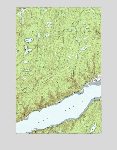
Lake Wooten, WA USGS Topographic Map
Click on map above to begin viewing in our Map Viewer.

This topographic map contains these locations and features:
Feature Name Type Latitude Longitude GNIS ID View Map
Belfair State ParkParkN47.4295°W122.8768°1516384View Map
Belfair-Tahuya DivisionCivilN47.4478°W122.9638°2628213View Map
Bennettsen LakeSwampN47.4718°W122.9553°1532392View Map
Bennettsen Lake DamDamN47.4698°W122.9596°1532391View Map
Camp PondSwampN47.4840°W122.9021°1517302View Map
Camp SpillmanLocaleN47.4773°W122.9268°1517313View Map
Christine LakeLakeN47.4717°W122.9678°1530044View Map
Christine Lake DamDamN47.4698°W122.9663°1532089View Map
Collins LakeLakeN47.4370°W122.9847°1517961View Map
Dewatto CemeteryCemeteryN47.4977°W122.9938°1518734View Map
Erdman LakeLakeN47.4455°W122.9870°1519369View Map
Forest BeachPopulated PlaceN47.3826°W122.9465°1519686View Map
Haven LakeLakeN47.4570°W122.9838°1520607View Map
Howell LakeLakeN47.4300°W122.9900°1521003View Map
Lake WootenLakeN47.4673°W122.9816°1528314View Map
Little Mission CreekStreamN47.4284°W122.8776°1522263View Map
Long MarshSwampN47.4585°W122.9025°1522402View Map
North Mason Regional Fire Authority Station 22BuildingN47.4297°W122.8845°2643853View Map
North Mason Regional Fire Authority Station 23BuildingN47.3824°W122.8899°2767940View Map
North Mason Regional Fire Authority Station 25BuildingN47.3754°W122.9414°2643852View Map
North Mason Regional Fire Authority Station 27BuildingN47.4325°W122.9828°2643473View Map
Oak Patch LakeSwampN47.4765°W122.9156°1523954View Map
Prickett LakeLakeN47.3802°W122.8883°1524644View Map
Shoofly CreekStreamN47.3898°W122.9852°1525700View Map
Stimson CreekStreamN47.4156°W122.9074°1526572View Map
Suckell PondSwampN47.4790°W122.8986°1526663View Map
SunbeachPopulated PlaceN47.4234°W122.8954°1526735View Map
Sunset BeachPopulated PlaceN47.4081°W122.8854°1526771View Map
Tahuya Division (historical)CensusN47.4456°W122.9863°1939652View Map
Tahuya LookoutLocaleN47.4676°W122.9204°1526902View Map
Twin LakesLakeN47.4838°W122.9520°1527538View Map

Note: Coordinates in the location and feature list above are referenced to NAD83 datum.


Copyright (C) 2008-2024 Ryan Niemi / Sunset Dynamics ... All Rights Reserved