TopoQuest Logo
Do you find TopoQuest useful?
Help keep TopoQuest running and adding new maps/features by donating!
Bitcoin:  19c7KJd3qBynnjoSw5npx9KScwjBe4ifkT
Litecoin:  LXs6TkuXGGXo1vDsWCkWVdjQX94eUKd6ui
Home View Maps Find Maps Find Places Resources & Links


Elgin, Oklahoma Topographic Map

USGS Map Title: Elgin, OK
USGS Map MRC: 34098G3
DRG (GeoTIFF) Download: o34098g3.tif


Neighboring USGS Topographic Map Quads:


  Boone, OK  
34098H4
 

  Apache, OK  
34098H3
 

  Cyril, OK  
34098H2
 

  Richards Spur, OK  
34098G4
 

  Elgin, OK  
34098G3
 

  Fletcher, OK  
34098G2
 

  Fort Sill, OK  
34098F4
 

  Arbuckle Hill, OK  
34098F3
 

  Sterling, OK  
34098F2


Map MRC Location:

N35°
W99°
N35°
W98°
H8 H7 H6 H5 H4 H3 H2 H1
G8 G7 G6 G5 G4 G3 G2 G1
F8 F7 F6 F5 F4 F3 F2 F1
E8 E7 E6 E5 E4 E3 E2 E1
D8 D7 D6 D5 D4 D3 D2 D1
C8 C7 C6 C5 C4 C3 C2 C1
B8 B7 B6 B5 B4 B3 B2 B1
A8 A7 A6 A5 A4 A3 A2 A1
N34°
W99°
N34°
W98°

Elgin, OK USGS 1:24K Topographic Map Preview:
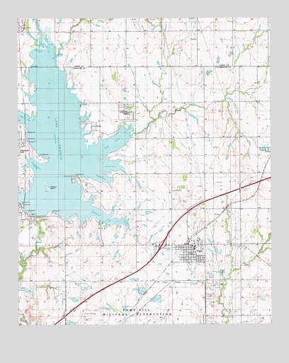
Elgin, OK USGS Topographic Map
Click on map above to begin viewing in our Map Viewer.

This topographic map contains these locations and features:
Feature Name Type Latitude Longitude GNIS ID View Map
Church of ApacheChurchN34.8715°W98.3742°1777430View Map
City of ElginCivilN34.7848°W98.3010°2410421View Map
Comanche County Memorial Hospital Ambulance Service - ElginBuildingN34.7827°W98.2951°2695842View Map
Cove AcresPopulated PlaceN34.8315°W98.3370°1101084View Map
Cove Acres Volunteer Fire DepartmentBuildingN34.8294°W98.3361°2658618View Map
Duck PondLakeN34.7666°W98.3465°1101090View Map
ElginPopulated PlaceN34.7803°W98.2923°1092522View Map
Elgin CemeteryCemeteryN34.7821°W98.2858°1092523View Map
Elgin Elementary SchoolSchoolN34.7816°W98.2881°1790639View Map
Elgin High SchoolSchoolN34.7821°W98.2882°2713078View Map
Elgin Memorial CemeteryCemeteryN34.7814°W98.2648°1101094View Map
Elgin Middle SchoolSchoolN34.7820°W98.2877°1790638View Map
Elgin Police DepartmentBuildingN34.7830°W98.2950°2757570View Map
Elgin RidgeLocaleN34.7676°W98.3003°1777431View Map
Elgin Volunteer Fire DepartmentBuildingN34.7827°W98.2951°2658387View Map
Elgin's Stony FieldAirportN34.7819°W98.2731°2770589View Map
Ellsworth DamDamN34.7951°W98.3670°1758627View Map
First Baptist ChurchChurchN34.7753°W98.2901°1783162View Map
First United Methodist ChurchChurchN34.7759°W98.2923°1783163View Map
Fort Sill National CemeteryCemeteryN34.7639°W98.3475°1955109View Map
Frisco RidgeRidgeN34.7526°W98.3431°1093070View Map
Fulton ArmBayN34.8159°W98.3301°1101086View Map
Goodin ArmBayN34.8103°W98.3345°1101087View Map
Hasenbach ArmBayN34.7959°W98.3370°1101089View Map
Hunting Horse PondLakeN34.7566°W98.3294°1101093View Map
Lake EllsworthReservoirN34.8224°W98.3537°1092549View Map
Lake Ellsworth AdditionPopulated PlaceN34.8370°W98.3217°1101085View Map
Love PondLakeN34.7602°W98.3478°1101092View Map
Mann ArmBayN34.8342°W98.3728°1101082View Map
Martin ArmBayN34.8603°W98.3545°1101081View Map
Menard PondReservoirN34.7640°W98.3142°1102159View Map
Northeast Corner PondLakeN34.7668°W98.2876°1777432View Map
Northeast Corner PondLakeN34.7668°W98.2874°1101097View Map
Nunn CreekStreamN34.8648°W98.3539°1101080View Map
O'Connell PondReservoirN34.7604°W98.3081°1102163View Map
Oknoname 031001 DamDamN34.7701°W98.2803°1753501View Map
Oknoname 031001 ReservoirReservoirN34.7704°W98.2806°1753502View Map
Oknoname 031002 DamDamN34.7634°W98.2503°1753503View Map
Oknoname 031007 DamDamN34.7501°W98.2503°1754849View Map
Oknoname 031016 DamDamN34.7917°W98.3320°1753527View Map
Quannett PondLakeN34.7504°W98.3509°1101098View Map
Rock CreekStreamN34.7734°W98.3728°1097310View Map
Rudd PondReservoirN34.7564°W98.3229°1102165View Map
Saint Ann ChurchChurchN34.7831°W98.2823°1777433View Map
Saint Ann's ChurchChurchN34.7828°W98.2887°1102166View Map
Saint Anns CemeteryCemeteryN34.7829°W98.2711°1101095View Map
Saint Anns ChurchChurchN34.7826°W98.2901°1101096View Map
Schammahorn SloughBayN34.8153°W98.3681°1101083View Map
Tony CreekStreamN34.8276°W98.3176°1098945View Map
Township of ChandlerCivilN34.7806°W98.3503°1825349View Map
Township of RichardCivilN34.7681°W98.2573°1825350View Map
Treasure IslandIslandN34.8056°W98.3606°1101088View Map
United Methodist Church of ApacheChurchN34.8712°W98.3737°1102157View Map
Upper Frisco PondLakeN34.7643°W98.3437°1101091View Map

Note: Coordinates in the location and feature list above are referenced to NAD83 datum.


Copyright (C) 2008-2024 Ryan Niemi / Sunset Dynamics ... All Rights Reserved