TopoQuest Logo
Do you find TopoQuest useful?
Help keep TopoQuest running and adding new maps/features by donating!
Bitcoin:  19c7KJd3qBynnjoSw5npx9KScwjBe4ifkT
Litecoin:  LXs6TkuXGGXo1vDsWCkWVdjQX94eUKd6ui
Home View Maps Find Maps Find Places Resources & Links


Elkhorn City, Kentucky Topographic Map

USGS Map Title: Elkhorn City, KY
USGS Map MRC: 37082C3
DRG (GeoTIFF) Download: o37082c3.tif


Neighboring USGS Topographic Map Quads:


  Millard, KY  
37082D4
 

  Lick Creek, KY  
37082D3
 

  Jamboree, KY  
37082D2
 

  Hellier, KY  
37082C4
 

  Elkhorn City, KY  
37082C3
 

  Harman, VA  
37082C2
 

  Clintwood, VA  
37082B4
 

  Haysi, VA  
37082B3
 

  Prater, VA  
37082B2


Map MRC Location:

N38°
W83°
N38°
W82°
H8 H7 H6 H5 H4 H3 H2 H1
G8 G7 G6 G5 G4 G3 G2 G1
F8 F7 F6 F5 F4 F3 F2 F1
E8 E7 E6 E5 E4 E3 E2 E1
D8 D7 D6 D5 D4 D3 D2 D1
C8 C7 C6 C5 C4 C3 C2 C1
B8 B7 B6 B5 B4 B3 B2 B1
A8 A7 A6 A5 A4 A3 A2 A1
N37°
W83°
N37°
W82°

Elkhorn City, KY USGS 1:24K Topographic Map Preview:
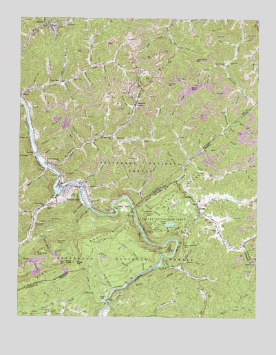
Elkhorn City, KY USGS Topographic Map
Click on map above to begin viewing in our Map Viewer.

This topographic map contains these locations and features:
Feature Name Type Latitude Longitude GNIS ID View Map
Abes ForkStreamN37.3165°W82.2858°1481255View Map
Abner ForkStreamN37.3534°W82.3379°485732View Map
Axel HollowValleyN37.3534°W82.2789°486165View Map
Bear HollowValleyN37.3377°W82.3155°486568View Map
Beaver BottomPopulated PlaceN37.3148°W82.3604°486605View Map
Beaver CreekStreamN37.3134°W82.3604°486608View Map
Beaver Creek (historical)Populated PlaceN37.3211°W82.3425°2337494View Map
Beaver Creek ChurchChurchN37.3248°W82.3263°486614View Map
Beaver Creek SchoolSchoolN37.3246°W82.3238°486615View Map
Beaver KnobSummitN37.3462°W82.2849°486623View Map
Beaver RidgeRidgeN37.3401°W82.2904°486625View Map
Bee Tree BranchStreamN37.3126°W82.2568°1481587View Map
BelcherPopulated PlaceN37.3418°W82.3735°486774View Map
Belcher Post Office (historical)Post OfficeN37.3419°W82.3742°2337497View Map
Belcher Regional AirportAirportN37.3707°W82.3221°2444079View Map
Big BranchStreamN37.2932°W82.3671°487133View Map
Big Island BranchStreamN37.2951°W82.3368°487199View Map
Blue Head BranchStreamN37.2837°W82.3690°487516View Map
Blue Head RockSummitN37.2759°W82.3651°487517View Map
Blue Pond ForkStreamN37.3457°W82.3649°487532View Map
Board ForkStreamN37.3359°W82.3704°487574View Map
BreaksPopulated PlaceN37.2959°W82.2810°1494190View Map
Breaks Elementary SchoolSchoolN37.2990°W82.2801°1497427View Map
Breaks Interstate ParkParkN37.2904°W82.2949°1481976View Map
Breaks Post OfficePost OfficeN37.2936°W82.2788°2766343View Map
Brushy ForkStreamN37.3548°W82.3310°488115View Map
Camp Branch CreekStreamN37.2757°W82.2963°1482247View Map
Camp Branch GapGapN37.2801°W82.2885°1482248View Map
Card Creek ChurchChurchN37.3571°W82.2643°488922View Map
Card MountainSummitN37.3687°W82.2763°488923View Map
Cedar Grove ChurchChurchN37.3140°W82.3571°489206View Map
CedarvillePopulated PlaceN37.3254°W82.3274°1669495View Map
Chestnut HollowValleyN37.3207°W82.3652°489450View Map
City of Cedarville (historical)CivilN37.3141°W82.3584°2404017View Map
City of Elkhorn CityCivilN37.3161°W82.3579°2403554View Map
Clinchfield OverlookLocaleN37.2865°W82.3046°1482586View Map
Cold Bank HollowValleyN37.3701°W82.3645°2355091View Map
Cold SpringSpringN37.2865°W82.3013°1482621View Map
Compton ForkStreamN37.3715°W82.3601°489918View Map
Cow ForkStreamN37.3158°W82.2871°490191View Map
Dilse BranchStreamN37.3205°W82.2788°490896View Map
Drafin School (historical)LocaleN37.3358°W82.3358°2120594View Map
DunlearyPopulated PlaceN37.3182°W82.3663°507892View Map
Dunleary HollowValleyN37.3174°W82.3670°491319View Map
Dunleary Post Office (historical)Post OfficeN37.3177°W82.3671°2337534View Map
Dunleary Railroad Station (historical)LocaleN37.3179°W82.3670°2337535View Map
Elkhorn CityPopulated PlaceN37.3040°W82.3510°491688View Map
Elkhorn City DivisionCivilN37.3288°W82.3549°1936987View Map
Elkhorn City Fire DepartmentBuildingN37.3043°W82.3446°2636626View Map
Elkhorn City Police DepartmentBuildingN37.3044°W82.3471°2767683View Map
Elkhorn City Post OfficePost OfficeN37.3046°W82.3509°2337542View Map
Elkhorn City Railroad Station (historical)LocaleN37.3050°W82.3415°2337543View Map
Elkhorn City SchoolSchoolN37.2998°W82.3557°516838View Map
Elkhorn CreekStreamN37.3010°W82.3549°509461View Map
Elswick HollowValleyN37.3174°W82.3622°491749View Map
Falls BranchStreamN37.2554°W82.3274°1483362View Map
FederalPopulated PlaceN37.3115°W82.3610°507985View Map
Federal Railroad Station (historical)LocaleN37.3117°W82.3599°2120621View Map
Ferrell (historical)Populated PlaceN37.3476°W82.3569°2120624View Map
Ferrell Creek ChurchChurchN37.3484°W82.3465°492051View Map
Ferrell Creek School (historical)SchoolN37.3513°W82.3452°2120625View Map
Ferrell Post Office (historical)Post OfficeN37.3461°W82.3633°2120626View Map
Ferrells Creek Area Fire DepartmentBuildingN37.3485°W82.3506°2636746View Map
Flat ForkStreamN37.3259°W82.3304°492188View Map
Garden HoleBayN37.2712°W82.3015°1483586View Map
Grassy ChurchChurchN37.2973°W82.2815°1483749View Map
Grassy CreekStreamN37.2958°W82.3141°493148View Map
Greasy SpearSummitN37.3365°W82.2850°2337557View Map
Hogston HollowValleyN37.3460°W82.3668°494366View Map
Honey ForkStreamN37.3468°W82.3549°494476View Map
Honey ForkPopulated PlaceN37.3473°W82.3540°508273View Map
Honey Fork CemeteryCemeteryN37.3483°W82.3534°2120832View Map
Houselog ForkStreamN37.3226°W82.3410°494642View Map
Hunt ForkStreamN37.3629°W82.2610°494774View Map
Hunts CreekStreamN37.3062°W82.2949°1484291View Map
Indian Grave ForkStreamN37.3627°W82.2935°494949View Map
Indian Grave GapGapN37.3576°W82.2826°494953View Map
Isham ForkStreamN37.3715°W82.3626°495038View Map
John Moore BranchStreamN37.3126°W82.3599°495330View Map
Laurel BranchStreamN37.2984°W82.3096°1484680View Map
Laurel BranchStreamN37.2673°W82.3129°1484679View Map
Laurel LakeReservoirN37.2890°W82.2958°1484717View Map
Laurel Lake DamDamN37.2886°W82.2980°1489601View Map
Left Fork Beaver CreekStreamN37.3248°W82.3263°496193View Map
Little Grassy BranchStreamN37.2984°W82.3090°496746View Map
Little Island BranchStreamN37.2973°W82.3385°496769View Map
Little Josie CemeteryCemeteryN37.3001°W82.2774°1497469View Map
Little Laurel BranchStreamN37.2690°W82.3093°1484920View Map
Locust ThicketStreamN37.3284°W82.2688°496966View Map
Looney CemeteryCemeteryN37.2862°W82.2707°1485081View Map
Lovers LeapCliffN37.2807°W82.2890°1485100View Map
Lower BranchStreamN37.3057°W82.3424°497262View Map
Luke HollowValleyN37.3532°W82.2763°497342View Map
Maple Camp ForkStreamN37.3291°W82.3048°2355116View Map
Meadow GapGapN37.2732°W82.2507°1485340View Map
Middle BranchStreamN37.3029°W82.3410°498095View Map
Middle Camp BranchStreamN37.2709°W82.2910°1485362View Map
Middle Fork Hunts CreekStreamN37.2965°W82.2804°1487058View Map
Middle Fork Road CreekStreamN37.3715°W82.3601°498136View Map
Middlefield ForkStreamN37.3471°W82.3596°498152View Map
Mike Grady Railroad Station (historical)LocaleN37.3396°W82.3131°2336917View Map
MikegradyPopulated PlaceN37.3396°W82.3124°508603View Map
Mouth of Beaver School (historical)SchoolN37.3144°W82.3584°2336928View Map
Mud LickStreamN37.3318°W82.2604°1485718View Map
Mud LickStreamN37.3207°W82.3451°498995View Map
Mullins BranchStreamN37.3309°W82.2649°499088View Map
Mullins CemeteryCemeteryN37.2926°W82.2751°1497473View Map
Mullins CemeteryCemeteryN37.3357°W82.2665°499094View Map
Old House ForkStreamN37.3202°W82.2794°499841View Map
Piney ForkStreamN37.3304°W82.2662°500731View Map
Pinnacle RockSummitN37.2815°W82.3546°500743View Map
Pond BranchStreamN37.2907°W82.3671°501029View Map
Pool PointCapeN37.2932°W82.3240°501067View Map
Pool Point BridgeBridgeN37.2953°W82.3246°2336989View Map
Pool Point TunnelTunnelN37.2946°W82.3257°501068View Map
Potter BranchStreamN37.3371°W82.3017°2355131View Map
Potter FlatsFlatN37.2971°W82.3232°501198View Map
Praise ForkStreamN37.3251°W82.3688°501266View Map
Priest ForkStreamN37.3237°W82.3368°501342View Map
RepublicPopulated PlaceN37.3726°W82.3629°508923View Map
Right Fork Beaver CreekStreamN37.3248°W82.3263°501862View Map
Road ForkStreamN37.3679°W82.2971°502011View Map
School House BranchStreamN37.3137°W82.2888°503048View Map
School Number Two (historical)SchoolN37.2728°W82.2728°2120741View Map
Senterville (historical)Populated PlaceN37.2946°W82.3652°2337023View Map
Shop BranchStreamN37.3265°W82.3674°503412View Map
Shortridge ForkStreamN37.3554°W82.2674°503457View Map
Simms BranchStreamN37.2896°W82.2701°1487252View Map
Skegg BranchStreamN37.2571°W82.3299°1487281View Map
Skegg GapGapN37.2723°W82.3440°503600View Map
Skegg HoleBayN37.2576°W82.3288°1487283View Map
Skegg KnobSummitN37.2723°W82.3482°503601View Map
Skegg TunnelTunnelN37.2565°W82.3271°1487284View Map
Slickrock ForkStreamN37.3479°W82.3515°503688View Map
Slone ForkStreamN37.3554°W82.2674°503707View Map
Song HollowValleyN37.3499°W82.3455°2355139View Map
Spencer GapGapN37.3482°W82.2968°504060View Map
Spring BranchStreamN37.2618°W82.3243°1487446View Map
Spruce Pine ForkStreamN37.3518°W82.3413°504177View Map
Spruce Pine IslandIslandN37.2971°W82.3407°504181View Map
State Line OverlookLocaleN37.2929°W82.3085°1487537View Map
State Line TunnelTunnelN37.2918°W82.3149°1475091View Map
Steward ForkStreamN37.3454°W82.2593°504376View Map
Stonecoal ForkStreamN37.3243°W82.3360°504473View Map
Sulphur Springs ChurchChurchN37.2959°W82.3621°504771View Map
The BreaksCliffN37.2882°W82.3101°1487816View Map
The Breaks OverlookLocaleN37.2893°W82.3085°1487817View Map
The ChimneySummitN37.2782°W82.3018°1494278View Map
The NotchesGapN37.2943°W82.3046°1487838View Map
The TowersSummitN37.2793°W82.2957°1494281View Map
The Towers OverlookLocaleN37.2854°W82.2907°1487857View Map
Tilley BranchStreamN37.3140°W82.2546°1487912View Map
Towers TunnelTunnelN37.2782°W82.2990°1487963View Map
Trace ForkStreamN37.3158°W82.2871°505431View Map
Upper BranchStreamN37.2982°W82.3390°505860View Map
Upper Camp BranchStreamN37.2732°W82.2874°1488071View Map
Upper Card Creek SchoolSchoolN37.3559°W82.2674°505867View Map
Upper Skegg ForkStreamN37.2607°W82.3371°1488077View Map
Weddington ForkStreamN37.3559°W82.3260°506351View Map
Willis BranchStreamN37.2534°W82.3568°1488395View Map
Willis CemeteryCemeteryN37.2529°W82.3513°1488400View Map
Wolfpen BranchStreamN37.3023°W82.3107°507038View Map

Note: Coordinates in the location and feature list above are referenced to NAD83 datum.


Copyright (C) 2008-2025 Ryan Niemi / Sunset Dynamics ... All Rights Reserved