TopoQuest Logo
Do you find TopoQuest useful?
Help keep TopoQuest running and adding new maps/features by donating!
Bitcoin:  19c7KJd3qBynnjoSw5npx9KScwjBe4ifkT
Litecoin:  LXs6TkuXGGXo1vDsWCkWVdjQX94eUKd6ui
Home View Maps Find Maps Find Places Resources & Links


Jamboree, Kentucky Topographic Map

USGS Map Title: Jamboree, KY
USGS Map MRC: 37082D2
DRG (GeoTIFF) Download: o37082d2.tif


Neighboring USGS Topographic Map Quads:


  Belfry, KY  
37082E3
 

  Matewan, WV  
37082E2
 

  Majestic, KY  
37082E1
 

  Lick Creek, KY  
37082D3
 

  Jamboree, KY  
37082D2
 

  Hurley, VA  
37082D1
 

  Elkhorn City, KY  
37082C3
 

  Harman, VA  
37082C2
 

  Grundy, VA  
37082C1


Map MRC Location:

N38°
W83°
N38°
W82°
H8 H7 H6 H5 H4 H3 H2 H1
G8 G7 G6 G5 G4 G3 G2 G1
F8 F7 F6 F5 F4 F3 F2 F1
E8 E7 E6 E5 E4 E3 E2 E1
D8 D7 D6 D5 D4 D3 D2 D1
C8 C7 C6 C5 C4 C3 C2 C1
B8 B7 B6 B5 B4 B3 B2 B1
A8 A7 A6 A5 A4 A3 A2 A1
N37°
W83°
N37°
W82°

Jamboree, KY USGS 1:24K Topographic Map Preview:
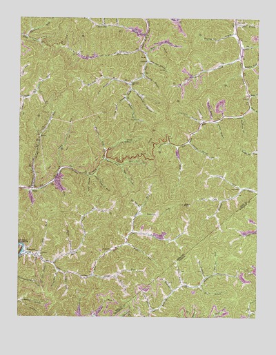
Jamboree, KY USGS Topographic Map
Click on map above to begin viewing in our Map Viewer.

This topographic map contains these locations and features:
Feature Name Type Latitude Longitude GNIS ID View Map
Add HollowValleyN37.4204°W82.1862°485777View Map
Allen BranchStreamN37.4565°W82.1546°485845View Map
Ash Lick ForkStreamN37.4726°W82.1912°486074View Map
Bear BranchStreamN37.3884°W82.1546°1462872View Map
Bear BranchStreamN37.4850°W82.1836°486524View Map
Beech CreekStreamN37.4848°W82.1340°486699View Map
Big BranchStreamN37.4968°W82.1985°487137View Map
Blackberry ForkStreamN37.4923°W82.2468°487397View Map
Buckhorn ForkStreamN37.4465°W82.1662°488270View Map
Calloway BranchStreamN37.4934°W82.1835°488626View Map
Calloway Branch (historical)Populated PlaceN37.4969°W82.2030°2120546View Map
ColemanPopulated PlaceN37.4815°W82.1832°489815View Map
Coleman BranchStreamN37.4668°W82.2479°489816View Map
Coleman Post Office (historical)Post OfficeN37.4870°W82.1572°2337430View Map
Coleman School (historical)SchoolN37.4873°W82.1869°2120565View Map
Colley ForkStreamN37.4240°W82.1435°489840View Map
Cow BranchStreamN37.3976°W82.2354°490171View Map
Cow BranchStreamN37.4746°W82.2015°490174View Map
Dicks BranchStreamN37.3882°W82.1640°1465782View Map
Dicks ForkStreamN37.4104°W82.1901°490883View Map
Dotson ForkStreamN37.4465°W82.1662°491031View Map
Dry ForkStreamN37.4009°W82.2399°491190View Map
DunlapPopulated PlaceN37.4282°W82.2424°507891View Map
Dunlap Post Office (historical)Post OfficeN37.4271°W82.2426°2337532View Map
Dunlap Railroad Station (historical)LocaleN37.4280°W82.2426°2337533View Map
Duty BranchStreamN37.4976°W82.1374°491368View Map
Feds CreekStreamN37.4018°W82.2474°492014View Map
Feds Creek High SchoolSchoolN37.4013°W82.2452°2120622View Map
Feds Creek Post Office (historical)Post OfficeN37.4021°W82.2452°2120623View Map
Feds Creek Volunteer Fire DepartmentBuildingN37.3981°W82.2323°2636483View Map
FedscreekPopulated PlaceN37.4034°W82.2451°492016View Map
Fedscreek Volunteer Fire Department Station 2BuildingN37.4061°W82.1930°2637349View Map
Fox HollowValleyN37.3817°W82.2480°492411View Map
Gap ForkStreamN37.4387°W82.1965°492680View Map
Grassy BranchStreamN37.4490°W82.1607°493141View Map
Grassy ForkStreamN37.4290°W82.1318°493156View Map
Grassy Spring BranchStreamN37.3779°W82.1790°1467375View Map
Henroost ForkStreamN37.4179°W82.1876°494053View Map
Henry BranchStreamN37.3921°W82.1982°494055View Map
Hensley BranchStreamN37.4759°W82.1846°494067View Map
Hurricane ForkStreamN37.4446°W82.2040°494831View Map
Hylton KnobSummitN37.4215°W82.1632°494870View Map
Jackson Rowe Elementary School (historical)SchoolN37.4056°W82.1957°2120850View Map
JamboreePopulated PlaceN37.4984°W82.1368°495153View Map
Jamboree Post Office (historical)Post OfficeN37.4994°W82.1370°2107416View Map
Jamboree Post Office (historical)Post OfficeN37.4853°W82.1341°2120852View Map
Jamboree School (historical)SchoolN37.4823°W82.1375°2107417View Map
Jess HollowValleyN37.3946°W82.1256°1468716View Map
Jones ForkStreamN37.4062°W82.1926°495498View Map
Kimper Volunteer Fire Department Station 4BuildingN37.4877°W82.2376°2637383View Map
King Camp BranchStreamN37.4668°W82.1937°495735View Map
Lang ForkStreamN37.3859°W82.1676°1469126View Map
Laurel ForkStreamN37.3923°W82.2110°496031View Map
Lee BranchStreamN37.3918°W82.1515°1469259View Map
Lick Log ForkStreamN37.3759°W82.2087°496514View Map
Linn BranchStreamN37.4282°W82.2443°496590View Map
Little Union ChurchChurchN37.3918°W82.2132°496885View Map
Low Gap BranchStreamN37.4820°W82.1828°497235View Map
Maria BranchStreamN37.4637°W82.1293°497540View Map
Miller BranchStreamN37.4015°W82.2218°498309View Map
Miller ForkStreamN37.4062°W82.1929°498339View Map
Motley (historical)Populated PlaceN37.4071°W82.2233°2336927View Map
Motley ForkStreamN37.3973°W82.2315°498683View Map
Mudlick ForkStreamN37.4340°W82.2132°499066View Map
Negro Camp ForkStreamN37.4340°W82.2121°499234View Map
Panther BranchStreamN37.4576°W82.1460°500150View Map
Paw Paw SchoolSchoolN37.4290°W82.1337°500280View Map
Peddler ForkStreamN37.3932°W82.2251°500343View Map
Phillips BranchStreamN37.4940°W82.1365°500529View Map
Phillips CemeteryCemeteryN37.4914°W82.1481°2336969View Map
Poor BranchStreamN37.4973°W82.2057°501075View Map
Prater BranchStreamN37.4682°W82.1299°501270View Map
Right Fork Spruce ForkStreamN37.4390°W82.1962°501929View Map
Road ForkStreamN37.4873°W82.1865°502014View Map
Rockhouse ForkStreamN37.4593°W82.1335°502196View Map
Rowland Row CampLocaleN37.4015°W82.2390°502432View Map
Second Big Creek ForkStreamN37.4290°W82.2429°503144View Map
Shop BranchStreamN37.4571°W82.1487°503416View Map
Smith ForkStreamN37.4873°W82.1865°503787View Map
Smith Fork SchoolSchoolN37.4734°W82.1910°503790View Map
Solomon ForkStreamN37.4798°W82.1332°503872View Map
Spruce ForkStreamN37.4412°W82.2054°504171View Map
Spruce Pine BranchStreamN37.3940°W82.2279°504174View Map
Staggerweed BranchStreamN37.4711°W82.1918°504231View Map
Steele Post OfficePost OfficeN37.4034°W82.2010°517537View Map
Steele Post Office (historical)Post OfficeN37.3929°W82.2108°2337048View Map
Steele Post Office (historical)Post OfficeN37.4116°W82.1899°2337049View Map
Third Fork Big CreekStreamN37.4371°W82.2271°505149View Map
Turkey BranchStreamN37.4882°W82.1346°505580View Map
Turkeypen ForkStreamN37.4323°W82.2315°505641View Map
Turnip BranchStreamN37.4568°W82.1532°505674View Map
Upper Feds Creek School (historical)SchoolN37.4112°W82.1899°2337079View Map
Wes Lee ForkStreamN37.3932°W82.1462°1476450View Map

Note: Coordinates in the location and feature list above are referenced to NAD83 datum.


Copyright (C) 2008-2024 Ryan Niemi / Sunset Dynamics ... All Rights Reserved