TopoQuest Logo
Do you find TopoQuest useful?
Help keep TopoQuest running and adding new maps/features by donating!
Bitcoin:  19c7KJd3qBynnjoSw5npx9KScwjBe4ifkT
Litecoin:  LXs6TkuXGGXo1vDsWCkWVdjQX94eUKd6ui
Home View Maps Find Maps Find Places Resources & Links


Elkton, Tennessee Topographic Map

USGS Map Title: Elkton, TN
USGS Map MRC: 35086A8
DRG (GeoTIFF) Download: o35086a8.tif


Neighboring USGS Topographic Map Quads:


  Pulaski, TN  
35087B1
 

  Tarpley, TN  
35086B8
 

  Frankewing, TN  
35086B7
 

  Aspen Hill, TN  
35087A1
 

  Elkton, TN  
35086A8
 

  Dellrose, TN  
35086A7
 

  Salem, AL  
34087H1
 

  Elkmont, AL  
34086H8
 

  Ardmore, AL  
34086H7


Map MRC Location:

N36°
W87°
N36°
W86°
H8 H7 H6 H5 H4 H3 H2 H1
G8 G7 G6 G5 G4 G3 G2 G1
F8 F7 F6 F5 F4 F3 F2 F1
E8 E7 E6 E5 E4 E3 E2 E1
D8 D7 D6 D5 D4 D3 D2 D1
C8 C7 C6 C5 C4 C3 C2 C1
B8 B7 B6 B5 B4 B3 B2 B1
A8 A7 A6 A5 A4 A3 A2 A1
N35°
W87°
N35°
W86°

Elkton, TN USGS 1:24K Topographic Map Preview:
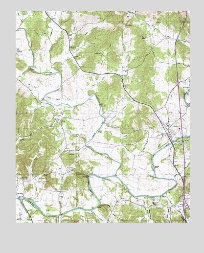
Elkton, TN USGS Topographic Map
Click on map above to begin viewing in our Map Viewer.

This topographic map contains these locations and features:
Feature Name Type Latitude Longitude GNIS ID View Map
Antioch ChurchChurchN35.0240°W86.9800°1275792View Map
Aspen Hill School (historical)SchoolN35.1017°W86.9975°1316253View Map
Beasley BranchStreamN35.0393°W86.9014°1276674View Map
Beasley IslandIslandN35.0331°W86.9014°1276687View Map
Beaty BranchStreamN35.0412°W86.8994°1276698View Map
Beech Grove Church (historical)ChurchN35.0051°W86.9322°1316254View Map
Bethany CemeteryCemeteryN35.1079°W86.8792°1277075View Map
Blowing Spring HollowValleyN35.0077°W86.8824°114524View Map
Brooks CemeteryCemeteryN35.1184°W86.8989°1278466View Map
Brown BranchStreamN35.1079°W86.8825°1310370View Map
Brown CemeteryCemeteryN35.0292°W86.9525°1278518View Map
Brown CemeteryCemeteryN35.1209°W86.9372°1278521View Map
Brown Chapel (historical)ChurchN35.0317°W86.9636°1316260View Map
Buchanan CreekStreamN35.0887°W86.9686°1305487View Map
Butler CemeteryCemeteryN35.1081°W86.9994°1279173View Map
Carter BranchStreamN35.0598°W86.9358°1279771View Map
Cave BranchStreamN35.0043°W86.9692°115714View Map
City of ElktonCivilN35.0618°W86.8976°2403557View Map
Cobb SpringSpringN35.0167°W86.9948°1280832View Map
Commissioner District 1CivilN35.0451°W86.9684°2464233View Map
ConwayPopulated PlaceN35.0912°W86.9536°1314881View Map
Conway SchoolSchoolN35.0876°W86.9406°1281102View Map
Conway SchoolSchoolN35.0995°W86.9381°1281103View Map
Croney CemeteryCemeteryN35.0273°W86.9033°1281657View Map
Daly CemeteryCemeteryN35.0137°W86.9244°1281995View Map
Dickson TownPopulated PlaceN35.0465°W86.8789°1282462View Map
Driver ChapelChurchN35.0465°W86.8806°1282809View Map
Dunnavant CemeteryCemeteryN35.0901°W86.9194°1283216View Map
Elder CemeteryCemeteryN35.0467°W86.9600°1283599View Map
ElktonPopulated PlaceN35.0523°W86.8886°1283659View Map
Elkton Baptist ChurchChurchN35.0545°W86.8911°1643990View Map
Elkton CemeteryCemeteryN35.0506°W86.8972°1643991View Map
Elkton CemeteryCemeteryN35.0495°W86.8892°1643992View Map
Elkton City HallBuildingN35.0520°W86.8892°1316090View Map
Elkton Cumberland Presbyterian ChurchChurchN35.0495°W86.8883°1643905View Map
Elkton Elementary SchoolSchoolN35.0570°W86.8903°1316269View Map
Elkton Fire DepartmentBuildingN35.0513°W86.8899°2653779View Map
Elkton Post OfficePost OfficeN35.0516°W86.8895°1650306View Map
Elkton United Methodist ChurchChurchN35.0526°W86.8914°1316091View Map
Elliot CemeteriesCemeteryN35.0137°W86.8772°1283664View Map
Ephesus ChurchChurchN35.1120°W86.9620°1283828View Map
Ezell BranchStreamN35.0073°W86.8836°1283949View Map
Gilbert BranchStreamN35.0140°W86.9875°1285365View Map
Giles County Fire and Rescue Squad ProspectBuildingN35.0253°W86.9943°2654257View Map
Haden BranchStreamN35.0112°W86.9386°1286481View Map
Hardy HollowValleyN35.0985°W86.9630°1286859View Map
Hasting CemeteryCemeteryN35.1229°W86.9922°1287093View Map
Henderson BranchStreamN35.0159°W86.9083°1287379View Map
Holland CreekStreamN35.0181°W86.8928°1288060View Map
Holt SchoolSchoolN35.0479°W86.8764°1288170View Map
Interchange 1CrossingN35.0134°W86.8792°1310378View Map
Interchange 6CrossingN35.0820°W86.8833°1310379View Map
James HollowValleyN35.0265°W86.9875°1647325View Map
Kelly CemeteryCemeteryN35.0470°W86.9514°1290028View Map
King BranchStreamN35.0492°W86.9458°1290187View Map
LibertyPopulated PlaceN35.0595°W86.9681°1291103View Map
Liberty BranchStreamN35.0681°W86.9603°1291109View Map
Lower Elkton (historical)Populated PlaceN35.0293°W86.9250°1310383View Map
Marks BranchStreamN35.1148°W86.9964°1292695View Map
Moore HollowValleyN35.0143°W86.9076°123015View Map
Neely CemeteryCemeteryN35.0404°W86.9611°1295323View Map
Negrotown BranchStreamN35.0837°W86.9389°1295355View Map
Nelson CemeteryCemeteryN35.0515°W86.9586°1295368View Map
New Hope ChurchChurchN35.1040°W86.9603°1295517View Map
Newton BranchStreamN35.0934°W86.9728°1295706View Map
Park CemeteryCemeteryN35.0648°W86.8900°1296779View Map
Persimmon Island BridgeBridgeN35.0692°W86.8758°1297231View Map
Petty BranchStreamN35.0912°W86.9906°1297271View Map
Pleasant Hill ChurchChurchN35.0115°W86.9019°1297860View Map
Polar Hill CemeteryCemeteryN35.0301°W86.9625°1644030View Map
Poplar HillPopulated PlaceN35.0309°W86.9597°1315760View Map
Poplar Hill ChurchChurchN35.0298°W86.9617°1316298View Map
Poplar Hill School (historical)SchoolN35.0337°W86.9639°1316299View Map
Potts BranchStreamN35.0706°W86.9745°1298363View Map
Potts CemeteryCemeteryN35.0706°W86.9794°1298365View Map
Prospect High School (historical)SchoolN35.0251°W86.9950°1322667View Map
Prospect Post OfficePost OfficeN35.0265°W86.9990°1650385View Map
Puckett BranchStreamN35.0542°W86.9408°1298643View Map
Ragsdale CreekStreamN35.0073°W86.9456°125409View Map
Reed BranchStreamN35.0048°W86.9686°1299116View Map
Reeves BranchStreamN35.0512°W86.8772°1299180View Map
Richland CreekStreamN35.0281°W86.9286°1299358View Map
Rolin HollowValleyN35.0105°W86.8889°125911View Map
Rolins Store (historical)LocaleN35.0098°W86.8856°1316309View Map
Silver CreekStreamN35.0748°W86.9453°1270274View Map
Simpson CemeteryCemeteryN35.0634°W86.9697°1270331View Map
Sinking CreekStreamN35.0245°W86.8847°1270381View Map
Sugartree FordCrossingN35.0984°W86.9872°1314354View Map
Trotter CemeteryCemeteryN35.0620°W86.9622°1272904View Map
Tucker BendBendN35.0742°W86.9728°1272935View Map
Turkey KnobSummitN35.1095°W86.9097°1273025View Map
Vinta MillPopulated PlaceN35.0698°W86.9392°1314460View Map
Ward BluffCliffN35.0209°W86.9467°1273770View Map
Whitfield CemeteryCemeteryN35.0165°W86.9658°1274475View Map
Whitfield IslandIslandN35.0129°W86.9883°1274477View Map
Wolf GapGapN35.1170°W86.9208°1274959View Map

Note: Coordinates in the location and feature list above are referenced to NAD83 datum.


Copyright (C) 2008-2024 Ryan Niemi / Sunset Dynamics ... All Rights Reserved