TopoQuest Logo
Do you find TopoQuest useful?
Help keep TopoQuest running and adding new maps/features by donating!
Bitcoin:  19c7KJd3qBynnjoSw5npx9KScwjBe4ifkT
Litecoin:  LXs6TkuXGGXo1vDsWCkWVdjQX94eUKd6ui
Home View Maps Find Maps Find Places Resources & Links


Tarpley, Tennessee Topographic Map

USGS Map Title: Tarpley, TN
USGS Map MRC: 35086B8
DRG (GeoTIFF) Download: o35086b8.tif


Neighboring USGS Topographic Map Quads:


  Milky Way, TN  
35087C1
 

  Brick Church, TN  
35086C8
 

  Cornersville, TN  
35086C7
 

  Pulaski, TN  
35087B1
 

  Tarpley, TN  
35086B8
 

  Frankewing, TN  
35086B7
 

  Aspen Hill, TN  
35087A1
 

  Elkton, TN  
35086A8
 

  Dellrose, TN  
35086A7


Map MRC Location:

N36°
W87°
N36°
W86°
H8 H7 H6 H5 H4 H3 H2 H1
G8 G7 G6 G5 G4 G3 G2 G1
F8 F7 F6 F5 F4 F3 F2 F1
E8 E7 E6 E5 E4 E3 E2 E1
D8 D7 D6 D5 D4 D3 D2 D1
C8 C7 C6 C5 C4 C3 C2 C1
B8 B7 B6 B5 B4 B3 B2 B1
A8 A7 A6 A5 A4 A3 A2 A1
N35°
W87°
N35°
W86°

Tarpley, TN USGS 1:24K Topographic Map Preview:
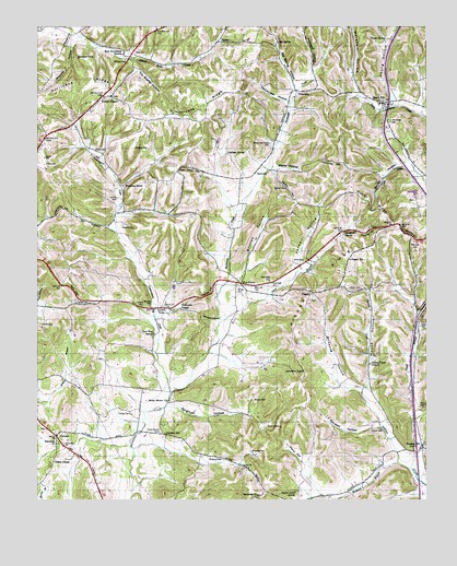
Tarpley, TN USGS Topographic Map
Click on map above to begin viewing in our Map Viewer.

This topographic map contains these locations and features:
Feature Name Type Latitude Longitude GNIS ID View Map
Abernathy CemeteryCemeteryN35.1829°W86.9250°1275422View Map
Abernathy HillSummitN35.2020°W86.9920°1275426View Map
Aymett CemeteryCemeteryN35.1754°W86.9578°1643974View Map
Aymett CemeteryCemeteryN35.1765°W86.9658°1276030View Map
Aymett RidgeRidgeN35.1879°W86.9895°1647318View Map
Aymett TownPopulated PlaceN35.1762°W86.9597°1314611View Map
Beech HillPopulated PlaceN35.2298°W86.8892°1276840View Map
Beech Hill CemeteryCemeteryN35.2306°W86.8883°1643977View Map
Beech Hill School (historical)SchoolN35.2298°W86.8897°1316256View Map
Bell HillSummitN35.1834°W86.9897°1276925View Map
Bethesda ChurchChurchN35.1265°W86.9292°1277143View Map
Big Henry HillSummitN35.2115°W86.9511°1277302View Map
Big SpringSpringN35.2457°W86.9225°1277396View Map
Big Spring HollowValleyN35.2352°W86.9176°1277415View Map
Birdsong BranchStreamN35.1348°W86.8833°1277513View Map
Birdsong CemeteryCemeteryN35.1362°W86.9400°1277514View Map
Birdsong CemeteryCemeteryN35.1381°W86.9308°1277515View Map
Birdsong HollowValleyN35.1536°W86.8956°1305257View Map
Blooming GrovePopulated PlaceN35.2081°W86.9720°1314695View Map
Bradley CemeteryCemeteryN35.1520°W86.9306°1278177View Map
Britton HollowValleyN35.1824°W86.9376°1278426View Map
Brown and Hayes CemeteryCemeteryN35.2195°W86.9247°1278505View Map
Bunker HillPopulated PlaceN35.1395°W86.8764°1269405View Map
Bunker Hill School (historical)SchoolN35.1387°W86.8753°1322665View Map
Campbell SpringSpringN35.1959°W86.9013°1279470View Map
Catfarm SpringSpringN35.2168°W86.9391°1279886View Map
Center Point Church (historical)ChurchN35.1273°W86.9169°1316265View Map
Center Point SchoolSchoolN35.1273°W86.9167°1280142View Map
Chambliss HillSummitN35.2148°W86.9061°1280224View Map
Cherry FlatValleyN35.1359°W86.9147°1305877View Map
Commissioner District 5CivilN35.1681°W86.9450°2464444View Map
Cucumber HollowValleyN35.1743°W86.8778°1281805View Map
Dry Branch HollowValleyN35.2412°W86.9695°1282894View Map
Eason CemeteryCemeteryN35.1715°W86.9981°1283317View Map
Five PointsPopulated PlaceN35.1826°W86.9342°1315058View Map
FriendshipPopulated PlaceN35.2329°W86.9156°1315082View Map
Glendale SchoolSchoolN35.1423°W86.9586°1285509View Map
Godfrey LakeLakeN35.2462°W86.8864°1285561View Map
Gunter HollowValleyN35.2134°W86.8817°1286444View Map
Gunter RidgeRidgeN35.2009°W86.8931°1286447View Map
Harris CemeteryCemeteryN35.2137°W86.9975°1286953View Map
Harwell HollowValleyN35.1865°W86.9170°1287082View Map
Harwell HollowValleyN35.1475°W86.8771°1287083View Map
Hopkins CemeteryCemeteryN35.1976°W86.9719°1288329View Map
Houze CemeteryCemeteryN35.1809°W86.8994°1288517View Map
Houze HollowValleyN35.1547°W86.8943°1288518View Map
Hurricane RidgeRidgeN35.2362°W86.9858°1269666View Map
Indian Creek CemeteryCemeteryN35.1609°W86.8931°1644000View Map
Indian Creek ChurchChurchN35.1609°W86.8925°1288970View Map
Ingram HillSummitN35.1806°W86.9453°1289011View Map
Leatherwood CreekStreamN35.1537°W86.9567°1290888View Map
Lewis ChapelChurchN35.1359°W86.9939°1291075View Map
Little Bradshaw CreekStreamN35.2295°W86.8853°1310382View Map
Maclin SchoolSchoolN35.1767°W86.9633°1292458View Map
Marks CemeteryCemeteryN35.2115°W86.9258°1292698View Map
Marks CemeteryCemeteryN35.2170°W86.9806°1292699View Map
Marks HollowValleyN35.2127°W86.9253°1292701View Map
Maxwell HillSummitN35.2442°W86.9922°1292985View Map
Maxwell HollowValleyN35.2465°W86.9869°1292986View Map
Mays CemeteryCemeteryN35.1712°W86.8772°1293028View Map
McAfee HillSummitN35.1951°W86.8803°1293069View Map
McAfee HillSummitN35.1959°W86.8947°1293070View Map
McCanless HollowValleyN35.2309°W86.9201°1293116View Map
McNeese CemeteryCemeteryN35.2179°W86.9683°1293442View Map
New Providence CemeteryCemeteryN35.2431°W86.9722°1644021View Map
New Providence ChurchChurchN35.2426°W86.9722°1295624View Map
New Zion SchoolSchoolN35.1690°W86.9620°1295676View Map
Newton HillSummitN35.2059°W86.9186°1295708View Map
North Fork Pigeon Roost CreekStreamN35.2495°W86.9889°1295908View Map
Oak Grove CemeteryCemeteryN35.2254°W86.8872°1296067View Map
Oliver BranchStreamN35.1717°W86.9408°1296413View Map
Oliver CemeteryCemeteryN35.1881°W86.9144°1296417View Map
Osburn CemeteryCemeteryN35.1440°W86.8897°1296502View Map
Phelps CemeteryCemeteryN35.1495°W86.8772°1297299View Map
PisgahPopulated PlaceN35.1804°W86.9119°1315726View Map
Pisgah CemeteryCemeteryN35.1787°W86.9119°1644053View Map
Pisgah ChurchChurchN35.1795°W86.9119°1644028View Map
Pisgah RidgeRidgeN35.1812°W86.9047°1297724View Map
Pisgah SchoolSchoolN35.1887°W86.8992°1297727View Map
Pleasant Hill Church (historical)ChurchN35.2056°W86.8967°1316295View Map
Powell ChapelChurchN35.2312°W86.9764°1298410View Map
Powell ChapelPopulated PlaceN35.2320°W86.9792°1647330View Map
Powell Chapel CemeteryCemeteryN35.2317°W86.9758°1644031View Map
Powell Chapel School (historical)SchoolN35.2317°W86.9792°1316300View Map
Rehoboth ChurchChurchN35.1404°W86.9939°1299201View Map
Rocky Mount CemeteryCemeteryN35.1431°W86.9600°1299913View Map
Rocky Mount ChurchChurchN35.1515°W86.9572°1299914View Map
Round HillSummitN35.1920°W86.8786°1300155View Map
Round Hill Church (historical)ChurchN35.1915°W86.8797°1316310View Map
Sanders HollowValleyN35.1450°W86.8900°1300701View Map
Sharon Church (historical)ChurchN35.1437°W86.9675°1316315View Map
Smith SubdivisionPopulated PlaceN35.1865°W86.9306°1647332View Map
Snuff BranchStreamN35.1337°W86.8803°1270790View Map
SumacPopulated PlaceN35.2462°W86.9408°1271826View Map
TarpleyPopulated PlaceN35.1423°W86.9933°1272132View Map
Tarpley CemeteryCemeteryN35.1781°W86.9872°1272135View Map
Thomas CemeteryCemeteryN35.1481°W86.9697°1272471View Map
Thompson ChapelChurchN35.1756°W86.9533°1304077View Map
Unity ChurchChurchN35.2073°W86.9206°1273270View Map
Williams CemeteryCemeteryN35.2404°W86.9706°1274637View Map
Williams HollowValleyN35.2389°W86.9117°1274709View Map
Worley CemeteryCemeteryN35.1812°W86.9350°1275127View Map
Worsham HollowValleyN35.2329°W86.8976°1275135View Map
Yankee HollowValleyN35.1728°W86.9417°1275228View Map
Young HollowValleyN35.2328°W86.8861°1275333View Map
Young SpringSpringN35.2467°W86.8878°1275336View Map

Note: Coordinates in the location and feature list above are referenced to NAD83 datum.


Copyright (C) 2008-2024 Ryan Niemi / Sunset Dynamics ... All Rights Reserved