TopoQuest Logo
Do you find TopoQuest useful?
Help keep TopoQuest running and adding new maps/features by donating!
Bitcoin:  19c7KJd3qBynnjoSw5npx9KScwjBe4ifkT
Litecoin:  LXs6TkuXGGXo1vDsWCkWVdjQX94eUKd6ui
Home View Maps Find Maps Find Places Resources & Links


Elsie, Oregon Topographic Map

USGS Map Title: Elsie, OR
USGS Map MRC: 45123G5
DRG (GeoTIFF) Download: o45123g5.tif


Neighboring USGS Topographic Map Quads:


  Saddle Mountain, OR  
45123H6
 

  Vinemaple, OR  
45123H5
 

  Sager Creek, OR  
45123H4
 

  Hamlet, OR  
45123G6
 

  Elsie, OR  
45123G5
 

  Sunset Spring, OR  
45123G4
 

  Cook Creek, OR  
45123F6
 

  Rogers Peak, OR  
45123F5
 

  Cochran, OR  
45123F4


Map MRC Location:

N46°
W124°
N46°
W123°
H8 H7 H6 H5 H4 H3 H2 H1
G8 G7 G6 G5 G4 G3 G2 G1
F8 F7 F6 F5 F4 F3 F2 F1
E8 E7 E6 E5 E4 E3 E2 E1
D8 D7 D6 D5 D4 D3 D2 D1
C8 C7 C6 C5 C4 C3 C2 C1
B8 B7 B6 B5 B4 B3 B2 B1
A8 A7 A6 A5 A4 A3 A2 A1
N45°
W124°
N45°
W123°

Elsie, OR USGS 1:24K Topographic Map Preview:
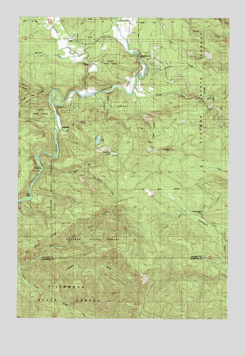
Elsie, OR USGS Topographic Map
Click on map above to begin viewing in our Map Viewer.

This topographic map contains these locations and features:
Feature Name Type Latitude Longitude GNIS ID View Map
Big CreekStreamN45.8712°W123.6096°1117607View Map
Bloom LakeLakeN45.8322°W123.5287°1132181View Map
Camp OlsonLocaleN45.7934°W123.5204°1118528View Map
Cedar CreekStreamN45.8596°W123.5762°1132286View Map
ElsiePopulated PlaceN45.8657°W123.5948°1136261View Map
Elsie - Vinemaple Rural Fire Protection District 11BuildingN45.8561°W123.5449°2577024View Map
Elsie Post Office (historical)Post OfficeN45.8657°W123.5948°1165212View Map
Flat Iron MountainSummitN45.8201°W123.5362°1120827View Map
Four Seven RidgeRidgeN45.7818°W123.6140°1120919View Map
George CreekStreamN45.8443°W123.6057°1121098View Map
Gold CreekStreamN45.8443°W123.6123°1132285View Map
Howard Rierson Spruce Run County ParkParkN45.8137°W123.6123°1132284View Map
Humbug CreekStreamN45.8426°W123.5860°1122128View Map
Jewell JunctionLocaleN45.8590°W123.5543°1122422View Map
Larsen CreekStreamN45.8601°W123.5932°1122963View Map
Little FallsFallsN45.7996°W123.6182°1123189View Map
Lost LakeLakeN45.8239°W123.5790°1123511View Map
Lost Lake CreekStreamN45.8284°W123.6021°1123512View Map
LukarillaPopulated PlaceN45.8273°W123.6018°1136504View Map
McClure CreekStreamN45.8587°W123.5898°1123914View Map
Middle Fork Cronin CreekStreamN45.7598°W123.6073°1124109View Map
MishawakaPopulated PlaceN45.8632°W123.5685°1160499View Map
Mishawaka Post Office (historical)Post OfficeN45.8498°W123.5512°1164519View Map
Nehalem County ParkParkN45.8487°W123.5332°2058192View Map
Nehalem ValleyValleyN45.8623°W123.5615°1124641View Map
North Fork Cronin CreekStreamN45.7709°W123.6240°1124764View Map
North Fork Quartz CreekStreamN45.8415°W123.5173°1124798View Map
Osweg CreekStreamN45.8537°W123.5498°1125054View Map
Pope - Meeker Drift Boat AccessLocaleN45.8732°W123.5697°2668618View Map
Pope CornerLocaleN45.8734°W123.5607°1136643View Map
Quartz CreekStreamN45.8457°W123.5582°1125729View Map
South Fork Cronin CreekStreamN45.7598°W123.6068°1127278View Map
South Fork Quartz CreekStreamN45.8415°W123.5173°1127311View Map
South Fork Spruce Run CreekStreamN45.8112°W123.5865°1127324View Map
Spruce Run CreekStreamN45.8126°W123.6123°1127462View Map
Spruce Run LakeLakeN45.8182°W123.5705°1127463View Map
Sunny Hill CemeteryCemeteryN45.8657°W123.5732°1127728View Map

Note: Coordinates in the location and feature list above are referenced to NAD83 datum.


Copyright (C) 2008-2024 Ryan Niemi / Sunset Dynamics ... All Rights Reserved