TopoQuest Logo
Do you find TopoQuest useful?
Help keep TopoQuest running and adding new maps/features by donating!
Bitcoin:  19c7KJd3qBynnjoSw5npx9KScwjBe4ifkT
Litecoin:  LXs6TkuXGGXo1vDsWCkWVdjQX94eUKd6ui
Home View Maps Find Maps Find Places Resources & Links


Emigrant, Montana Topographic Map

USGS Map Title: Emigrant, MT
USGS Map MRC: 45110C6
DRG (GeoTIFF) Download: o45110c6.tif


Neighboring USGS Topographic Map Quads:


  Big Draw, MT  
45110D7
 

  Pray, MT  
45110D6
 

  Dexter Point, MT  
45110D5
 

  Dailey Lake, MT  
45110C7
 

  Emigrant, MT  
45110C6
 

  Knowles Peak, MT  
45110C5
 

  Dome Mountain, MT  
45110B7
 

  Monitor Peak, MT  
45110B6
 

  Mineral Mountain, MT  
45110B5


Map MRC Location:

N46°
W111°
N46°
W110°
H8 H7 H6 H5 H4 H3 H2 H1
G8 G7 G6 G5 G4 G3 G2 G1
F8 F7 F6 F5 F4 F3 F2 F1
E8 E7 E6 E5 E4 E3 E2 E1
D8 D7 D6 D5 D4 D3 D2 D1
C8 C7 C6 C5 C4 C3 C2 C1
B8 B7 B6 B5 B4 B3 B2 B1
A8 A7 A6 A5 A4 A3 A2 A1
N45°
W111°
N45°
W110°

Emigrant, MT USGS 1:24K Topographic Map Preview:
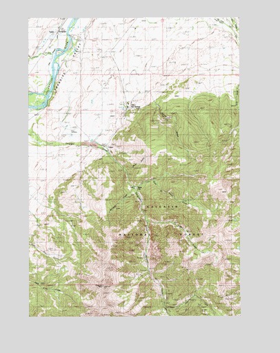
Emigrant, MT USGS Topographic Map
Click on map above to begin viewing in our Map Viewer.

This topographic map contains these locations and features:
Feature Name Type Latitude Longitude GNIS ID View Map
05S08E34ACB_01 SpringSpringN45.3613°W110.7222°809091View Map
06S08E12ACB_01 SpringSpringN45.3322°W110.6913°808965View Map
06S09E01CDC_01 SpringSpringN45.3366°W110.6924°808991View Map
06S09E01CDC_02 SpringSpringN45.3369°W110.6899°808990View Map
07S09E06ADD_01 WellWellN45.2566°W110.6610°808610View Map
07S09E06DDA_01 WellWellN45.2524°W110.6610°808590View Map
Alaska MineMineN45.3199°W110.6980°804872View Map
Allison MineMineN45.2577°W110.6680°804874View Map
Balm of Gilead CreekStreamN45.3038°W110.6880°779314View Map
Blacktail CreekStreamN45.3035°W110.6885°793673View Map
ChicoPopulated PlaceN45.3210°W110.7052°781213View Map
Chico Airport (historical)AirportN45.3402°W110.6897°1743083View Map
Chico CemeteryCemeteryN45.3277°W110.7262°781214View Map
Chico Hot SpringsPopulated PlaceN45.3377°W110.6922°781216View Map
Chico PeakSummitN45.3022°W110.6374°798828View Map
Chico Post Office (historical)Post OfficeN45.3210°W110.7052°1743191View Map
Chico School (historical)SchoolN45.3210°W110.7052°1743260View Map
Comanche MineMineN45.2569°W110.6349°804879View Map
Conlin GulchValleyN45.3394°W110.6755°781575View Map
East Fork Emigrant CreekStreamN45.2541°W110.6705°801831View Map
EmigrantPopulated PlaceN45.3702°W110.7335°783189View Map
Emigrant (historical)LocaleN45.3702°W110.7335°1743229View Map
Emigrant Fishing Access SiteLocaleN45.3688°W110.7247°1744537View Map
Emigrant GulchValleyN45.3174°W110.7022°783192View Map
Emigrant PeakSummitN45.2630°W110.7072°783193View Map
Emigrant Post OfficePost OfficeN45.3684°W110.7350°1743230View Map
Emigrant School (historical)SchoolN45.3702°W110.7335°1743232View Map
Fridley CreekStreamN45.2908°W110.6813°783753View Map
Fridley School (historical)SchoolN45.3702°W110.7335°1743231View Map
Golden Age Village Trailer ParkPopulated PlaceN45.3702°W110.7335°1743115View Map
Henry W Longfellow AcademySchoolN45.3702°W110.7335°1743272View Map
Ku Klux MineMineN45.3119°W110.6863°804873View Map
McAdow MineMineN45.2569°W110.6355°804877View Map
Mill Creek Flat DitchCanalN45.3727°W110.6355°787373View Map
Moze GulchValleyN45.3116°W110.6930°801838View Map
NW Section 5 MineMineN45.2597°W110.6633°804889View Map
Old ChicoLocaleN45.3180°W110.7058°794453View Map
Paradise Valley Fire DepartmentBuildingN45.3600°W110.7180°2546447View Map
Saint Johns ChurchChurchN45.3685°W110.7360°789933View Map
Saint Julian MineMineN45.2527°W110.6497°793684View Map
Saint Julian MineMineN45.2516°W110.6494°804875View Map
Sand Spur (historical)LocaleN45.3574°W110.7438°1743344View Map
Section 6 Placer MineMineN45.2527°W110.6647°804886View Map
Thomas Moore SchoolSchoolN45.3702°W110.7335°1743282View Map
Upland DitchCanalN45.3741°W110.6397°792604View Map
Wan-I- GanLocaleN45.3455°W110.7355°792795View Map
White CityPopulated PlaceN45.3038°W110.6863°793188View Map
Yellowstone City (historical)LocaleN45.3208°W110.7091°1743375View Map

Note: Coordinates in the location and feature list above are referenced to NAD83 datum.


Copyright (C) 2008-2024 Ryan Niemi / Sunset Dynamics ... All Rights Reserved