TopoQuest Logo
Do you find TopoQuest useful?
Help keep TopoQuest running and adding new maps/features by donating!
Bitcoin:  19c7KJd3qBynnjoSw5npx9KScwjBe4ifkT
Litecoin:  LXs6TkuXGGXo1vDsWCkWVdjQX94eUKd6ui
Home View Maps Find Maps Find Places Resources & Links


Dome Mountain, Montana Topographic Map

USGS Map Title: Dome Mountain, MT
USGS Map MRC: 45110B7
DRG (GeoTIFF) Download: o45110b7.tif


Neighboring USGS Topographic Map Quads:


  Lewis Creek, MT  
45110C8
 

  Dailey Lake, MT  
45110C7
 

  Emigrant, MT  
45110C6
 

  Miner, MT  
45110B8
 

  Dome Mountain, MT  
45110B7
 

  Monitor Peak, MT  
45110B6
 

  Sportsman Lake, MT  
45110A8
 

  Electric Peak, MT  
45110A7
 

  Gardiner, MT  
45110A6


Map MRC Location:

N46°
W111°
N46°
W110°
H8 H7 H6 H5 H4 H3 H2 H1
G8 G7 G6 G5 G4 G3 G2 G1
F8 F7 F6 F5 F4 F3 F2 F1
E8 E7 E6 E5 E4 E3 E2 E1
D8 D7 D6 D5 D4 D3 D2 D1
C8 C7 C6 C5 C4 C3 C2 C1
B8 B7 B6 B5 B4 B3 B2 B1
A8 A7 A6 A5 A4 A3 A2 A1
N45°
W111°
N45°
W110°

Dome Mountain, MT USGS 1:24K Topographic Map Preview:
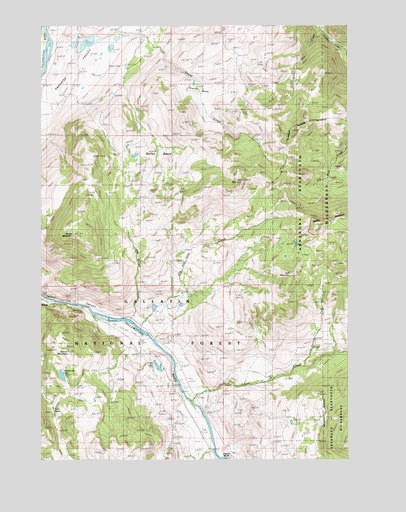
Dome Mountain, MT USGS Topographic Map
Click on map above to begin viewing in our Map Viewer.

This topographic map contains these locations and features:
Feature Name Type Latitude Longitude GNIS ID View Map
Banana Peel DamDamN45.1699°W110.8308°798407View Map
Cedar CreekStreamN45.1416°W110.8144°781101View Map
Corwin Springs Census Designated PlaceCensusN45.1278°W110.7997°2583801View Map
Cutler LakeLakeN45.1519°W110.8283°782008View Map
Dailey BasinBasinN45.2130°W110.8285°807004View Map
Dick Randall PointCliffN45.1394°W110.7899°768030View Map
Dome MountainSummitN45.1894°W110.8633°782459View Map
Duderanch Post Office (historical)Post OfficeN45.1485°W110.7827°1743245View Map
High MountainSummitN45.1783°W110.7741°807003View Map
Joe Brown CreekStreamN45.1652°W110.8399°785502View Map
Little Pine CreekStreamN45.2483°W110.7613°786340View Map
Mulherin (historical)LocaleN45.1277°W110.8052°1743361View Map
Mulherin CreekStreamN45.1277°W110.8052°801181View Map
OTO RanchLocaleN45.1485°W110.7824°788355View Map
Red MountainSummitN45.2049°W110.7944°789467View Map
Rigler BluffsCliffN45.1266°W110.7985°807001View Map
Second Fork Cedar CreekStreamN45.1519°W110.7694°790178View Map
Sheep CreekStreamN45.2469°W110.8472°790323View Map
Slip and Slide CreekStreamN45.1627°W110.8358°790678View Map
Slip and Slide Fishing Access SiteLocaleN45.1663°W110.8397°1744550View Map
Sphinx CreekStreamN45.1716°W110.8747°791150View Map
Sphinx MountainSummitN45.1555°W110.8649°807002View Map
Stands BasinBasinN45.2297°W110.8130°791424View Map
Thelma Number 1 DamDamN45.2433°W110.8624°795330View Map
Thelma Number 2 DamDamN45.2416°W110.8524°795331View Map
Thelma Number 3 DamDamN45.2433°W110.8508°795332View Map
Trestle RanchLocaleN45.1280°W110.8074°792367View Map
Twin LakesLakeN45.1379°W110.8704°792525View Map
Yankee Jim Canyon Point of InterestLocaleN45.1683°W110.8624°794559View Map
Yankee Jim LakeLakeN45.1493°W110.8673°793593View Map

Note: Coordinates in the location and feature list above are referenced to NAD83 datum.


Copyright (C) 2008-2024 Ryan Niemi / Sunset Dynamics ... All Rights Reserved