TopoQuest Logo
Do you find TopoQuest useful?
Help keep TopoQuest running and adding new maps/features by donating!
Bitcoin:  19c7KJd3qBynnjoSw5npx9KScwjBe4ifkT
Litecoin:  LXs6TkuXGGXo1vDsWCkWVdjQX94eUKd6ui
Home View Maps Find Maps Find Places Resources & Links


Emily, Minnesota Topographic Map

USGS Map Title: Emily, MN
USGS Map MRC: 46093F8
DRG (GeoTIFF) Download: o46093f8.tif


Neighboring USGS Topographic Map Quads:


  Mitchell Lake, MN  
46094G1
 

  Roosevelt Lake, MN  
46093G8
 

  Edna Lake, MN  
46093G7
 

  Cross Lake, MN  
46094F1
 

  Emily, MN  
46093F8
 

  Ross Lake, MN  
46093F7
 

  Trommald, MN  
46094E1
 

  Cuyuna, MN  
46093E8
 

  Iron Hub, MN  
46093E7


Map MRC Location:

N47°
W94°
N47°
W93°
H8 H7 H6 H5 H4 H3 H2 H1
G8 G7 G6 G5 G4 G3 G2 G1
F8 F7 F6 F5 F4 F3 F2 F1
E8 E7 E6 E5 E4 E3 E2 E1
D8 D7 D6 D5 D4 D3 D2 D1
C8 C7 C6 C5 C4 C3 C2 C1
B8 B7 B6 B5 B4 B3 B2 B1
A8 A7 A6 A5 A4 A3 A2 A1
N46°
W94°
N46°
W93°

Emily, MN USGS 1:24K Topographic Map Preview:
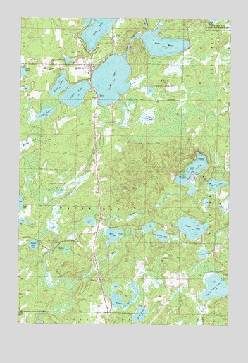
Emily, MN USGS Topographic Map
Click on map above to begin viewing in our Map Viewer.

This topographic map contains these locations and features:
Feature Name Type Latitude Longitude GNIS ID View Map
Andrews LakeLakeN46.7328°W93.9716°639367View Map
Bailey BogSwampN46.6982°W93.9964°639574View Map
Bass LakeLakeN46.6292°W93.9273°639691View Map
Dahler LakeLakeN46.7189°W93.9673°642592View Map
Eastham LakeLakeN46.6329°W93.9358°643125View Map
EmilyPopulated PlaceN46.7311°W93.9580°656158View Map
Emily City HallBuildingN46.7311°W93.9578°2071497View Map
Emily Greens Golf CourseLocaleN46.7278°W93.9856°2071522View Map
Emily Lake DamDamN46.7166°W93.9469°1775966View Map
Emily Lookout TowerTowerN46.6805°W93.9328°659831View Map
Emily Police DepartmentBuildingN46.7304°W93.9564°2758684View Map
Emily Post OfficePost OfficeN46.7312°W93.9590°2071498View Map
Emily State ForestForestN46.7236°W93.9144°643339View Map
Emily Volunteer Fire DepartmentBuildingN46.7305°W93.9636°2666236View Map
Emily Wayside ParkParkN46.7172°W93.9531°2094123View Map
Fairfield CemeteryCemeteryN46.6644°W93.9933°2071521View Map
Island LakeReservoirN46.6872°W93.8971°1775971View Map
Island LakeLakeN46.7107°W93.9854°645484View Map
Island Lake DamDamN46.6783°W93.8953°1775970View Map
Kellys PointCapeN46.6863°W93.8978°646083View Map
Lake EmilyReservoirN46.7251°W93.9459°1775967View Map
Lake Emily Resort and CampgroundLocaleN46.7311°W93.9556°2071495View Map
Lake MaryLakeN46.7395°W93.9159°647598View Map
Little Bass LakeLakeN46.6649°W93.9227°646752View Map
Lookums IslandIslandN46.6927°W93.8903°647160View Map
Magbee IslandIslandN46.6883°W93.8975°647372View Map
Ministers PointCapeN46.6858°W93.9014°647909View Map
Mud BrookStreamN46.6402°W93.9694°648198View Map
Mud LakeLakeN46.6614°W93.9434°648309View Map
Mud LakeLakeN46.6826°W93.8833°648312View Map
Olson LakeLakeN46.6543°W93.8902°648955View Map
Pickerel LakeLakeN46.6614°W93.9154°649370View Map
Pine Ridge CemeteryCemeteryN46.7366°W93.9675°649491View Map
Roger LakeLakeN46.6648°W93.8973°650220View Map
Ruth LakeLakeN46.7492°W93.9534°658120View Map
Saint Emily Catholic ChurchChurchN46.7311°W93.9578°2071496View Map
Slough LakeLakeN46.7093°W93.9246°652161View Map
Spruce LakeLakeN46.6554°W93.9716°652508View Map
Square LakeLakeN46.6572°W93.9913°652518View Map
Township of FairfieldCivilN46.6732°W93.9670°664130View Map
Trout LakeLakeN46.7223°W93.9770°653347View Map
Upper Dean LakeLakeN46.6404°W93.8827°653544View Map
Upper Dean State Wildlife Management AreaParkN46.6463°W93.8764°653545View Map
Van Sickle BrookStreamN46.7458°W93.9247°658835View Map

Note: Coordinates in the location and feature list above are referenced to NAD83 datum.


Copyright (C) 2008-2025 Ryan Niemi / Sunset Dynamics ... All Rights Reserved