TopoQuest Logo
Do you find TopoQuest useful?
Help keep TopoQuest running and adding new maps/features by donating!
Bitcoin:  19c7KJd3qBynnjoSw5npx9KScwjBe4ifkT
Litecoin:  LXs6TkuXGGXo1vDsWCkWVdjQX94eUKd6ui
Home View Maps Find Maps Find Places Resources & Links


Trommald, Minnesota Topographic Map

USGS Map Title: Trommald, MN
USGS Map MRC: 46094E1
DRG (GeoTIFF) Download: o46094e1.tif


Neighboring USGS Topographic Map Quads:


  Lower Whitefish Lake, MN  
46094F2
 

  Cross Lake, MN  
46094F1
 

  Emily, MN  
46093F8
 

  Pelican Lake, MN  
46094E2
 

  Trommald, MN  
46094E1
 

  Cuyuna, MN  
46093E8
 

  Merrifield, MN  
46094D2
 

  Riverton, MN  
46094D1
 

  Crosby, MN  
46093D8


Map MRC Location:

N47°
W95°
N47°
W94°
H8 H7 H6 H5 H4 H3 H2 H1
G8 G7 G6 G5 G4 G3 G2 G1
F8 F7 F6 F5 F4 F3 F2 F1
E8 E7 E6 E5 E4 E3 E2 E1
D8 D7 D6 D5 D4 D3 D2 D1
C8 C7 C6 C5 C4 C3 C2 C1
B8 B7 B6 B5 B4 B3 B2 B1
A8 A7 A6 A5 A4 A3 A2 A1
N46°
W95°
N46°
W94°

Trommald, MN USGS 1:24K Topographic Map Preview:
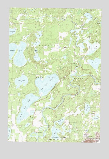
Trommald, MN USGS Topographic Map
Click on map above to begin viewing in our Map Viewer.

This topographic map contains these locations and features:
Feature Name Type Latitude Longitude GNIS ID View Map
Bass LakeLakeN46.5570°W94.1072°639690View Map
Black Bear LakeLakeN46.5083°W94.0608°640204View Map
Blackbear LakeReservoirN46.5116°W94.0669°1775975View Map
Blackbear Lake DamDamN46.5116°W94.0669°1775974View Map
City of TrommaldCivilN46.5057°W94.0155°2397057View Map
Coles LakeLakeN46.5317°W94.0184°641394View Map
Crow Wing State ForestForestN46.5652°W94.0519°642511View Map
Duck LakeLakeN46.5441°W94.1106°642953View Map
Evergreen CemeteryCemeteryN46.5181°W94.0931°2071517View Map
Faupel LakeLakeN46.5156°W94.0988°643580View Map
Flanders LakeLakeN46.5984°W94.0851°643726View Map
Flynn LakeLakeN46.5226°W94.0060°643766View Map
Fool LakeLakeN46.5742°W94.0084°643786View Map
Google LakeLakeN46.6181°W94.0180°644232View Map
Greenwood LakeLakeN46.6024°W94.1224°646973View Map
Half Moon LakeLakeN46.5053°W94.0899°644574View Map
Horseshoe LakeLakeN46.5822°W94.1139°645244View Map
Little Bass LakeLakeN46.5785°W94.0872°646750View Map
Little Pine RiverStreamN46.6027°W94.0333°657103View Map
Lower Mission LakeLakeN46.5329°W94.1002°647256View Map
ManganesePopulated PlaceN46.5275°W94.0097°654811View Map
Manganese Post Office (historical)Post OfficeN46.5275°W94.0094°2071681View Map
Maroco MineMineN46.5011°W94.0128°647549View Map
Miller LakeLakeN46.5189°W94.0551°647875View Map
MissionPopulated PlaceN46.5880°W94.0511°654833View Map
Mission Beach Resort and CampgroundLocaleN46.5431°W94.0722°2071466View Map
Mission CemeteryCemeteryN46.5588°W94.0514°647976View Map
Mission CreekStreamN46.5105°W94.0755°647985View Map
Mission Post Office (historical)Post OfficeN46.5881°W94.0508°2071679View Map
Mud LakeLakeN46.5849°W94.0888°648306View Map
Musser MineMineN46.5091°W94.0047°648404View Map
Ossipee Community ChurchChurchN46.5694°W94.0383°2071463View Map
Pelican BrookStreamN46.6152°W94.1030°649231View Map
Pine RiverStreamN46.5639°W94.0367°659997View Map
Sunset Bay Resort and CampgroundLocaleN46.5431°W94.0722°2071467View Map
Township of MissionCivilN46.5891°W94.0804°665001View Map
Township of WolfordCivilN46.5300°W94.0059°666036View Map
TrommaldPopulated PlaceN46.5052°W94.0183°653329View Map
Trommald Post Office (historical)Post OfficeN46.5053°W94.0181°2071655View Map
Upper Mission LakeLakeN46.5552°W94.0708°653555View Map
Wolford CemeteryCemeteryN46.5181°W94.0006°2071516View Map

Note: Coordinates in the location and feature list above are referenced to NAD83 datum.


Copyright (C) 2008-2024 Ryan Niemi / Sunset Dynamics ... All Rights Reserved