TopoQuest Logo
Do you find TopoQuest useful?
Help keep TopoQuest running and adding new maps/features by donating!
Bitcoin:  19c7KJd3qBynnjoSw5npx9KScwjBe4ifkT
Litecoin:  LXs6TkuXGGXo1vDsWCkWVdjQX94eUKd6ui
Home View Maps Find Maps Find Places Resources & Links


Empire Ranch, Arizona Topographic Map

USGS Map Title: Empire Ranch, AZ
USGS Map MRC: 31110G6
DRG (GeoTIFF) Download: o31110g6.tif


Neighboring USGS Topographic Map Quads:


  Corona De Tucson, AZ  
31110H7
 

  Mount Fagan, AZ  
31110H6
 

  The Narrows, AZ  
31110H5
 

  Helvetia, AZ  
31110G7
 

  Empire Ranch, AZ  
31110G6
 

  Spring Water Canyon, AZ  
31110G5
 

  Mount Wrightson, AZ  
31110F7
 

  Sonoita, AZ  
31110F6
 

  Elgin, AZ  
31110F5


Map MRC Location:

N32°
W111°
N32°
W110°
H8 H7 H6 H5 H4 H3 H2 H1
G8 G7 G6 G5 G4 G3 G2 G1
F8 F7 F6 F5 F4 F3 F2 F1
E8 E7 E6 E5 E4 E3 E2 E1
D8 D7 D6 D5 D4 D3 D2 D1
C8 C7 C6 C5 C4 C3 C2 C1
B8 B7 B6 B5 B4 B3 B2 B1
A8 A7 A6 A5 A4 A3 A2 A1
N31°
W111°
N31°
W110°

Empire Ranch, AZ USGS 1:24K Topographic Map Preview:
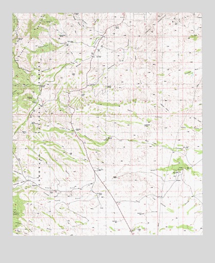
Empire Ranch, AZ USGS Topographic Map
Click on map above to begin viewing in our Map Viewer.

This topographic map contains these locations and features:
Feature Name Type Latitude Longitude GNIS ID View Map
Adobe TankReservoirN31.8288°W110.7057°37125View Map
Airport WellWellN31.7990°W110.6379°37128View Map
Andrada TankReservoirN31.8119°W110.6635°37141View Map
Barrel CanyonValleyN31.8687°W110.6770°26006View Map
Barrel SpringSpringN31.8662°W110.6851°26007View Map
Barrel TankReservoirN31.8082°W110.7418°37160View Map
California GulchValleyN31.7818°W110.7415°27176View Map
Colorado GulchValleyN31.7751°W110.7173°27824View Map
East DamDamN31.8409°W110.7112°37280View Map
East Fork Davidson CanyonValleyN31.8531°W110.6701°37281View Map
Empire RanchLocaleN31.7854°W110.6423°28902View Map
Empire Ranch Airport (historical)AirportN31.7937°W110.6312°37287View Map
Empire SchoolSchoolN31.7812°W110.7056°28903View Map
Empire WellWellN31.7826°W110.6823°37288View Map
Enzenberg CanyonValleyN31.7818°W110.7415°28910View Map
Fig Tree SpringSpringN31.8604°W110.7464°37297View Map
Helena MineMineN31.8729°W110.7092°29854View Map
Hidden Valley RanchLocaleN31.8576°W110.7123°29954View Map
High Haven RanchLocaleN31.7873°W110.6942°29963View Map
Highway CanyonValleyN31.8190°W110.6473°29973View Map
Highway TankReservoirN31.8096°W110.7092°37340View Map
Los Posos TankReservoirN31.7735°W110.6917°37377View Map
Maternity WellWellN31.7620°W110.6659°37395View Map
McCleary CanyonValleyN31.8448°W110.7201°31627View Map
North Basin TankReservoirN31.8132°W110.7383°37435View Map
Oak Tree WindmillWellN31.8051°W110.6851°37440View Map
Oakdale TankReservoirN31.7696°W110.7197°37441View Map
Papago CanyonValleyN31.8662°W110.7020°32663View Map
Questa SpringSpringN31.8340°W110.6887°37482View Map
Rosemont CampPopulated PlaceN31.8251°W110.7348°37495View Map
Rosemont JunctionPopulated PlaceN31.8343°W110.7329°37496View Map
Rosemont SpringsSpringN31.8284°W110.7387°33806View Map
Scholefield CanyonValleyN31.8568°W110.7012°34138View Map
Scholefield SpringSpringN31.8648°W110.7173°34139View Map
Sucker GulchValleyN31.7506°W110.7381°34913View Map
Thurber RanchLocaleN31.7754°W110.7237°35311View Map
Trail CanyonValleyN31.7806°W110.7098°35427View Map
V R CampLocaleN31.8251°W110.7345°35743View Map
Wasp CanyonValleyN31.8340°W110.7326°35912View Map
West WellWellN31.7579°W110.6820°37588View Map

Note: Coordinates in the location and feature list above are referenced to NAD83 datum.


Copyright (C) 2008-2025 Ryan Niemi / Sunset Dynamics ... All Rights Reserved