TopoQuest Logo
Do you find TopoQuest useful?
Help keep TopoQuest running and adding new maps/features by donating!
Bitcoin:  19c7KJd3qBynnjoSw5npx9KScwjBe4ifkT
Litecoin:  LXs6TkuXGGXo1vDsWCkWVdjQX94eUKd6ui
Home View Maps Find Maps Find Places Resources & Links


Englewood, Tennessee Topographic Map

USGS Map Title: Englewood, TN
USGS Map MRC: 35084D4
DRG (GeoTIFF) Download: o35084d4.tif


Neighboring USGS Topographic Map Quads:


  Niota, TN  
35084E5
 

  Sweetwater, TN  
35084E4
 

  Madisonville, TN  
35084E3
 

  Athens, TN  
35084D5
 

  Englewood, TN  
35084D4
 

  Mount Vernon, TN  
35084D3
 

  Etowah, TN  
35084C5
 

  Mecca, TN  
35084C4
 

  Tellico Plains, TN  
35084C3


Map MRC Location:

N36°
W85°
N36°
W84°
H8 H7 H6 H5 H4 H3 H2 H1
G8 G7 G6 G5 G4 G3 G2 G1
F8 F7 F6 F5 F4 F3 F2 F1
E8 E7 E6 E5 E4 E3 E2 E1
D8 D7 D6 D5 D4 D3 D2 D1
C8 C7 C6 C5 C4 C3 C2 C1
B8 B7 B6 B5 B4 B3 B2 B1
A8 A7 A6 A5 A4 A3 A2 A1
N35°
W85°
N35°
W84°

Englewood, TN USGS 1:24K Topographic Map Preview:
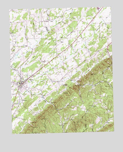
Englewood, TN USGS Topographic Map
Click on map above to begin viewing in our Map Viewer.

This topographic map contains these locations and features:
Feature Name Type Latitude Longitude GNIS ID View Map
Adams CemeteryCemeteryN35.3751°W84.4355°1327445View Map
ArdenPopulated PlaceN35.4217°W84.4094°1314595View Map
Beaver BranchGutN35.4648°W84.4930°1276707View Map
Bill Jack GapGapN35.3817°W84.4744°1277458View Map
BurgerPopulated PlaceN35.3990°W84.4441°1314773View Map
Burger BranchStreamN35.4170°W84.4808°1305534View Map
Burns CemeteryCemeteryN35.4731°W84.4971°1279086View Map
Caltharp SchoolSchoolN35.4367°W84.4260°1279341View Map
Caltharp School (historical)SchoolN35.4454°W84.4116°1308282View Map
Carson BranchStreamN35.4854°W84.3852°1279755View Map
Cave Spring BranchStreamN35.4542°W84.4227°1279961View Map
Chestua Baptist ChurchChurchN35.4617°W84.4235°1642737View Map
Chestua CemeteryCemeteryN35.4628°W84.4233°1317888View Map
ChestueePopulated PlaceN35.4665°W84.4171°1314836View Map
City of Madisonville DamDamN35.4867°W84.3849°1301869View Map
Cline BranchStreamN35.4298°W84.4294°1280745View Map
Cochran BranchStreamN35.4117°W84.4619°1280841View Map
Cochran CemeteryCemeteryN35.4184°W84.4752°1280843View Map
Commissioner District 3CivilN35.4079°W84.4946°2464171View Map
Dancing BranchStreamN35.4892°W84.4266°1304743View Map
Dry HollowValleyN35.4605°W84.4750°1282989View Map
EbenezerPopulated PlaceN35.3823°W84.3866°1647007View Map
Ebenezer ChurchChurchN35.4001°W84.4005°1283467View Map
EnglewoodPopulated PlaceN35.4245°W84.4874°1283789View Map
Englewood Christian ChurchChurchN35.4248°W84.4852°1648004View Map
Englewood Division (historical)CensusN35.4234°W84.4788°1648841View Map
Englewood Elementary SchoolSchoolN35.4245°W84.4835°1307521View Map
Englewood High School (historical)SchoolN35.4240°W84.4841°1642262View Map
Englewood LibraryBuildingN35.4254°W84.4877°1648005View Map
Englewood Methodist ChurchChurchN35.4270°W84.4877°1648006View Map
Englewood Mini-ParkParkN35.4259°W84.4860°1648007View Map
Englewood Police DepartmentBuildingN35.4254°W84.4875°2765761View Map
Englewood Post OfficePost OfficeN35.4265°W84.4881°1649298View Map
Englewood Rural Fire DepartmentBuildingN35.4264°W84.4899°2654392View Map
Estanelle SchoolSchoolN35.3842°W84.3833°1283856View Map
Estes Kefauver Lake DamDamN35.4984°W84.3899°1301874View Map
Ferguson BranchStreamN35.4070°W84.4988°1284207View Map
Fiesta BranchStreamN35.4504°W84.4938°1275393View Map
First Baptist ChurchChurchN35.4270°W84.4869°1648008View Map
Gay SpringSpringN35.3884°W84.4263°1285259View Map
Gravely BranchStreamN35.4845°W84.3863°1328315View Map
GudgerPopulated PlaceN35.4745°W84.4241°1286370View Map
Gudger Community Volunteer Fire DepartmentBuildingN35.4762°W84.4208°2654827View Map
Hance SchoolSchoolN35.4012°W84.4002°1286713View Map
Happy HollowValleyN35.4413°W84.3765°1286761View Map
Hickory Grove ChurchChurchN35.4201°W84.3769°1287588View Map
Hicks-Brown SpringSpringN35.4589°W84.4877°1642268View Map
Ho (historical)Populated PlaceN35.4606°W84.3799°1308301View Map
Isbell CemeteryCemeteryN35.4867°W84.4969°1289070View Map
Jess Moore BranchStreamN35.3826°W84.4221°1289415View Map
Johnson KnobSummitN35.4145°W84.4296°1289640View Map
Kelly KnobSummitN35.3854°W84.4733°1290040View Map
Kinser BranchStreamN35.4829°W84.4427°1290270View Map
Land CemeteryCemeteryN35.4045°W84.4177°1290582View Map
Liberty HillPopulated PlaceN35.3823°W84.4374°1315392View Map
Liberty Hill church of ChristChurchN35.3851°W84.4377°1642273View Map
Liberty HIll School (historical)SchoolN35.3840°W84.4377°1307538View Map
Little Chestuee CreekStreamN35.4212°W84.4763°1291426View Map
Luther Bookout KnobSummitN35.4329°W84.4024°1292307View Map
Madisonville Industrial ParkLocaleN35.4959°W84.4046°1308315View Map
Madisonville LakeReservoirN35.4995°W84.3908°1301875View Map
ManilaPopulated PlaceN35.4626°W84.4785°1315457View Map
Manila School (historical)SchoolN35.4459°W84.4799°1307541View Map
Manilla Chapel Baptist ChurchChurchN35.4631°W84.4849°1320146View Map
Mars Hill CemeteryCemeteryN35.3909°W84.4880°1956317View Map
Mars Hill ChurchChurchN35.3904°W84.4880°1292738View Map
Martin GapGapN35.3898°W84.4591°1292834View Map
Mason HollowValleyN35.4358°W84.3860°1647020View Map
McConkey SchoolSchoolN35.4190°W84.3988°1293178View Map
McDaniel KnobSummitN35.4417°W84.3869°1308318View Map
Millers Chapel SchoolSchoolN35.3751°W84.4738°1293972View Map
Monroe County Farm (historical)LocaleN35.4692°W84.3885°1308322View Map
Mount Arnon CemeteryCemeteryN35.4506°W84.4635°1956476View Map
Mount Arnon Church (historical)ChurchN35.4504°W84.4633°1307547View Map
Mount Arnon SchoolSchoolN35.4501°W84.4627°1294551View Map
New Bethel CemeteryCemeteryN35.4292°W84.3866°1317912View Map
New Bethel ChurchChurchN35.4287°W84.3855°1295426View Map
NonaburgPopulated PlaceN35.4123°W84.4613°1315608View Map
Old EnglewoodPopulated PlaceN35.4087°W84.4866°1315646View Map
Rider KnobSummitN35.4270°W84.4116°1299389View Map
Rocky BranchStreamN35.4395°W84.4972°1299851View Map
Rough Hill ChurchChurchN35.4276°W84.4216°1300147View Map
Saint Marys CemeteryCemeteryN35.4870°W84.4566°1956490View Map
Saint Marys ChurchChurchN35.4867°W84.4563°1300479View Map
Sinkhole CreekGutN35.3973°W84.3827°1270370View Map
Stanford BranchStreamN35.4701°W84.4608°1271234View Map
Town of EnglewoodCivilN35.4226°W84.4887°2406451View Map
Warner CoveValleyN35.3910°W84.4745°1273814View Map
Wilson BranchStreamN35.4262°W84.4416°1274789View Map
Wilson KnobSummitN35.4056°W84.4449°1274837View Map
Wilson StationLocaleN35.4223°W84.4158°1304629View Map

Note: Coordinates in the location and feature list above are referenced to NAD83 datum.


Copyright (C) 2008-2024 Ryan Niemi / Sunset Dynamics ... All Rights Reserved