TopoQuest Logo
Do you find TopoQuest useful?
Help keep TopoQuest running and adding new maps/features by donating!
Bitcoin:  19c7KJd3qBynnjoSw5npx9KScwjBe4ifkT
Litecoin:  LXs6TkuXGGXo1vDsWCkWVdjQX94eUKd6ui
Home View Maps Find Maps Find Places Resources & Links


Enka, North Carolina Topographic Map

USGS Map Title: Enka, NC
USGS Map MRC: 35082E6
DRG (GeoTIFF) Download: o35082e6.tif


Neighboring USGS Topographic Map Quads:


  Sandymush, NC  
35082F7
 

  Leicester, NC  
35082F6
 

  Weaverville, NC  
35082F5
 

  Canton, NC  
35082E7
 

  Enka, NC  
35082E6
 

  Asheville, NC  
35082E5
 

  Cruso, NC  
35082D7
 

  Dunsmore Mountain, NC  
35082D6
 

  Skyland, NC  
35082D5


Map MRC Location:

N36°
W83°
N36°
W82°
H8 H7 H6 H5 H4 H3 H2 H1
G8 G7 G6 G5 G4 G3 G2 G1
F8 F7 F6 F5 F4 F3 F2 F1
E8 E7 E6 E5 E4 E3 E2 E1
D8 D7 D6 D5 D4 D3 D2 D1
C8 C7 C6 C5 C4 C3 C2 C1
B8 B7 B6 B5 B4 B3 B2 B1
A8 A7 A6 A5 A4 A3 A2 A1
N35°
W83°
N35°
W82°

Enka, NC USGS 1:24K Topographic Map Preview:
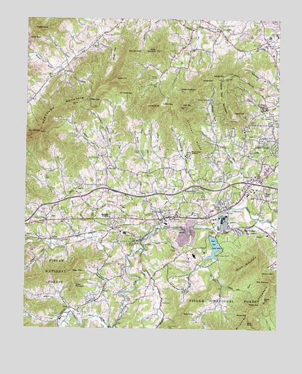
Enka, NC USGS Topographic Map
Click on map above to begin viewing in our Map Viewer.

This topographic map contains these locations and features:
Feature Name Type Latitude Longitude GNIS ID View Map
ActonPopulated PlaceN35.5615°W82.6390°1018765View Map
Asheville Fire and Rescue Station 10BuildingN35.5648°W82.6338°2639166View Map
Baldwin Field BranchStreamN35.5176°W82.6518°980482View Map
Baldwin GapGapN35.5232°W82.6323°980484View Map
Beaverdam CreekStreamN35.5321°W82.6915°1009085View Map
Beaverdam Wildlife Restoration AreaParkN35.5148°W82.6382°1009092View Map
Bert MountainSummitN35.6112°W82.7004°1019100View Map
Big CoveValleyN35.5519°W82.7320°1009292View Map
Bill Moore CreekStreamN35.5404°W82.6574°1009398View Map
Brooks BranchStreamN35.6096°W82.7287°981966View Map
Brooks CemeteryCemeteryN35.5102°W82.6816°981968View Map
Brooks CoveValleyN35.5690°W82.6925°981972View Map
Bryson BranchStreamN35.5526°W82.6979°982084View Map
CandlerPopulated PlaceN35.5365°W82.6929°982582View Map
Candler HeightsPopulated PlaceN35.5401°W82.7062°1019505View Map
Candler Post OfficePost OfficeN35.5463°W82.6631°2766583View Map
Candler SchoolSchoolN35.5384°W82.6999°982583View Map
Case CoveValleyN35.5216°W82.6684°982725View Map
Cedar Hill CemeteryCemeteryN35.5862°W82.6296°982865View Map
Clyde A Erwin High SchoolSchoolN35.6184°W82.6293°983305View Map
Cole CemeteryCemeteryN35.5987°W82.7429°1018052View Map
Corinth ChurchChurchN35.6121°W82.6757°983560View Map
Cowan CoveValleyN35.5900°W82.6313°983644View Map
Curtis CreekStreamN35.5032°W82.7296°1010623View Map
Deaver View MountainSummitN35.6009°W82.6518°984039View Map
Dix Creek ChapelChurchN35.6223°W82.6526°984217View Map
Dix Creek GapGapN35.5951°W82.6976°984218View Map
Edgewood ChurchChurchN35.5515°W82.6524°984635View Map
EnkaPopulated PlaceN35.5498°W82.6501°984794View Map
Enka Candler Fire and RescueBuildingN35.5396°W82.6845°2638843View Map
Enka High SchoolSchoolN35.5537°W82.6640°984795View Map
Enka LakeReservoirN35.5333°W82.6564°984796View Map
Enka Lake DamDamN35.5379°W82.6585°999074View Map
Enka Post OfficePost OfficeN35.5388°W82.6519°2766587View Map
Enka QuarryMineN35.5392°W82.6692°2648494View Map
Enka VillagePopulated PlaceN35.5409°W82.6446°1020158View Map
Erwin Hills Shopping CenterLocaleN35.6134°W82.6299°1024960View Map
Forest Lawn Memorial ParkCemeteryN35.5436°W82.6626°985282View Map
Francis Ashbury ChurchChurchN35.5576°W82.6729°985362View Map
George BranchStreamN35.5346°W82.7368°1011462View Map
GeorgetownPopulated PlaceN35.6209°W82.6543°1020416View Map
GladyPopulated PlaceN35.5087°W82.7271°1020437View Map
Grace ChapelChurchN35.6143°W82.7171°985881View Map
Gudger CemeteryCemeteryN35.5404°W82.7046°986185View Map
Happy Valley ChurchChurchN35.5951°W82.6260°986379View Map
Harkins CemeteryCemeteryN35.5509°W82.6479°986410View Map
Hayes CoveValleyN35.6131°W82.7087°986544View Map
Hayes TopSummitN35.6009°W82.7062°1020655View Map
Herren CoveValleyN35.5747°W82.7079°986651View Map
Hice Hill CemeteryCemeteryN35.5615°W82.6907°986682View Map
High PointSummitN35.5868°W82.6479°1020754View Map
High TopSummitN35.5901°W82.6740°986768View Map
Holcombe CoveValleyN35.5588°W82.6663°986915View Map
HominyPopulated PlaceN35.5459°W82.6762°1020814View Map
Hominy ChurchChurchN35.5390°W82.7029°987006View Map
Hooker GapGapN35.5929°W82.7199°987026View Map
J and J Fishing LakeReservoirN35.5968°W82.6432°999143View Map
J and J Trout LakeDamN35.5968°W82.6432°999142View Map
JugtownPopulated PlaceN35.5576°W82.7229°1020999View Map
Justice CemeteryCemeteryN35.5459°W82.6995°987862View Map
Justice RidgeRidgeN35.5496°W82.7051°987863View Map
Liberty ChurchChurchN35.5648°W82.6821°988412View Map
Little Pole CreekStreamN35.5482°W82.6849°988737View Map
LutherPopulated PlaceN35.5359°W82.7368°1021310View Map
Luther CemeteryCemeteryN35.5435°W82.6735°989134View Map
Luther CoveValleyN35.5700°W82.6845°989135View Map
Luther GapGapN35.5904°W82.6832°989136View Map
Luther KnobSummitN35.5907°W82.6910°1021311View Map
Mease GapGapN35.5101°W82.6335°989695View Map
Milksick CoveValleyN35.5715°W82.7101°989853View Map
Miller MountainSummitN35.5962°W82.6665°1021465View Map
Montmorenci ChurchChurchN35.5346°W82.6937°990161View Map
Moore CreekStreamN35.5479°W82.6512°990176View Map
Moors GapGapN35.5123°W82.6310°990211View Map
Morgan BranchStreamN35.5071°W82.7265°1013693View Map
Morgan BranchStreamN35.6057°W82.7329°1013694View Map
Morgan CoveValleyN35.5328°W82.7360°1013697View Map
Mount Moriah ChurchChurchN35.5479°W82.7143°990440View Map
Mount Pisgah AcademySchoolN35.5693°W82.6710°990504View Map
Mount View ChurchChurchN35.5821°W82.6418°990615View Map
New CandlerPopulated PlaceN35.5454°W82.6787°1021626View Map
New Morgan Hill ChurchChurchN35.5298°W82.6551°991073View Map
NewfoundPopulated PlaceN35.6043°W82.7318°1021643View Map
Oak Forest ChurchChurchN35.5523°W82.6285°991348View Map
Oak Hill ChurchChurchN35.5704°W82.6579°991419View Map
OwltownPopulated PlaceN35.6001°W82.7237°1021772View Map
Peggy PeakSummitN35.5226°W82.7274°1021856View Map
Piney MountainSummitN35.6123°W82.6862°1023707View Map
Piney MountainSummitN35.5171°W82.7246°1021963View Map
Piney Mountain ChurchChurchN35.5126°W82.7146°992383View Map
Pisgah SchoolSchoolN35.5034°W82.7310°992418View Map
Pisgah View ChurchChurchN35.5779°W82.6393°992419View Map
Pisgah View Memorial ParkCemeteryN35.5454°W82.6854°992420View Map
Pleasant Hill ChurchChurchN35.5429°W82.7404°992528View Map
Pole CreekStreamN35.5412°W82.6779°992631View Map
Pole CreekPopulated PlaceN35.5657°W82.7074°1022021View Map
Pole Creek ChurchChurchN35.5687°W82.7140°992632View Map
Potato GapGapN35.6171°W82.7490°1014612View Map
Potato KnobSummitN35.6209°W82.7462°1022060View Map
Reeves ChapelChurchN35.5387°W82.6260°993220View Map
Rice PinnacleSummitN35.5193°W82.6282°1022244View Map
Ridgeway CemeteryCemeteryN35.5354°W82.7498°1014890View Map
Ridgeway ChurchChurchN35.5476°W82.6787°993347View Map
Sand HillPopulated PlaceN35.5526°W82.6307°1022476View Map
Sand Hill Middle SchoolSchoolN35.5532°W82.6296°1006463View Map
Sand Hill Primary SchoolSchoolN35.5543°W82.6396°1006462View Map
Scott MountainSummitN35.5251°W82.6410°1022523View Map
Sheep GapGapN35.5057°W82.6390°994611View Map
Snow Hill ChurchChurchN35.5698°W82.7124°995069View Map
South Hominy CreekStreamN35.5359°W82.6915°1015701View Map
Spivey GapGapN35.6001°W82.6576°995308View Map
Spivey MountainSummitN35.6012°W82.6521°995310View Map
Starnes CoveValleyN35.5760°W82.6560°995425View Map
Starnes Cove ChurchChurchN35.5709°W82.6401°995426View Map
Starnes Cove Fishing Lake DamDamN35.5921°W82.6585°999134View Map
Starnes Cove LakesReservoirN35.5922°W82.6586°995427View Map
Starnes RidgeRidgeN35.5782°W82.6665°995428View Map
Sunrise ChurchChurchN35.5829°W82.6254°995703View Map
The PinnacleSummitN35.5796°W82.7426°1022932View Map
Thrash DamDamN35.5784°W82.6882°999109View Map
Thrash LakeReservoirN35.5801°W82.6890°999110View Map
Township of Lower HominyCivilN35.5435°W82.6397°1026452View Map
Township of Upper HominyCivilN35.5091°W82.7278°1026456View Map
Trull CemeteryCemeteryN35.5612°W82.7296°996280View Map
WBMU-FM (Asheville)TowerN35.6007°W82.6518°1018283View Map
Webb BranchStreamN35.5368°W82.7151°996911View Map
West Buncombe Volunteer Fire and RescueBuildingN35.6156°W82.6294°2638338View Map
White Rock ChurchChurchN35.5048°W82.7326°997204View Map
Wise BranchStreamN35.5259°W82.6629°997509View Map
Wise KnobSummitN35.5054°W82.6710°1023288View Map
Wolf KnobSummitN35.5023°W82.6393°1023297View Map
Woodland Terrace ChurchChurchN35.5773°W82.6326°997594View Map
Woodside HillsPopulated PlaceN35.5540°W82.6718°1023319View Map
Young BranchStreamN35.5465°W82.6832°997728View Map
Young CoveValleyN35.5192°W82.7093°997729View Map
Zion Hill ChurchChurchN35.6093°W82.7260°997801View Map

Note: Coordinates in the location and feature list above are referenced to NAD83 datum.


Copyright (C) 2008-2024 Ryan Niemi / Sunset Dynamics ... All Rights Reserved