TopoQuest Logo
Do you find TopoQuest useful?
Help keep TopoQuest running and adding new maps/features by donating!
Bitcoin:  19c7KJd3qBynnjoSw5npx9KScwjBe4ifkT
Litecoin:  LXs6TkuXGGXo1vDsWCkWVdjQX94eUKd6ui
Home View Maps Find Maps Find Places Resources & Links


Weaverville, North Carolina Topographic Map

USGS Map Title: Weaverville, NC
USGS Map MRC: 35082F5
DRG (GeoTIFF) Download: o35082f5.tif


Neighboring USGS Topographic Map Quads:


  Marshall, NC  
35082G6
 

  Mars Hill, NC  
35082G5
 

  Barnardsville, NC  
35082G4
 

  Leicester, NC  
35082F6
 

  Weaverville, NC  
35082F5
 

  Craggy Pinnacle, NC  
35082F4
 

  Enka, NC  
35082E6
 

  Asheville, NC  
35082E5
 

  Oteen, NC  
35082E4


Map MRC Location:

N36°
W83°
N36°
W82°
H8 H7 H6 H5 H4 H3 H2 H1
G8 G7 G6 G5 G4 G3 G2 G1
F8 F7 F6 F5 F4 F3 F2 F1
E8 E7 E6 E5 E4 E3 E2 E1
D8 D7 D6 D5 D4 D3 D2 D1
C8 C7 C6 C5 C4 C3 C2 C1
B8 B7 B6 B5 B4 B3 B2 B1
A8 A7 A6 A5 A4 A3 A2 A1
N35°
W83°
N35°
W82°

Weaverville, NC USGS 1:24K Topographic Map Preview:
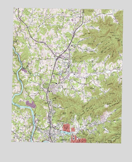
Weaverville, NC USGS Topographic Map
Click on map above to begin viewing in our Map Viewer.

This topographic map contains these locations and features:
Feature Name Type Latitude Longitude GNIS ID View Map
AlexanderPopulated PlaceN35.7025°W82.6188°2745928View Map
Alexander ChapelChurchN35.6737°W82.5943°980089View Map
Alexander Post OfficePost OfficeN35.7070°W82.6181°2745962View Map
Asbury Memorial ChurchChurchN35.6346°W82.5498°1018858View Map
Ashelawn Gardens of Memory Memorial GardenCemeteryN35.6712°W82.5968°980322View Map
Asheville-Weaverville SpeedwayLocaleN35.7384°W82.5587°980325View Map
Baird CoveValleyN35.6575°W82.5789°980440View Map
Baird MountainSummitN35.6657°W82.5726°1018906View Map
Beaver LakeReservoirN35.6344°W82.5634°980815View Map
Beaver Lake DamDamN35.6359°W82.5690°999183View Map
Beaver Lake Golf CourseLocaleN35.6423°W82.5504°980816View Map
Beaverdam ChurchChurchN35.6429°W82.5360°980831View Map
Beaverdam CreekStreamN35.6409°W82.5979°980837View Map
Beaverdam Volunteer Fire DepartmentBuildingN35.6419°W82.5316°2638673View Map
Belew HollowValleyN35.7107°W82.5338°1018631View Map
Blue BranchStreamN35.6809°W82.6135°981618View Map
Boyds Union ChapelChurchN35.6768°W82.5712°981792View Map
Bradley CemeteryCemeteryN35.6854°W82.5018°981804View Map
Brank CemeteryCemeteryN35.6937°W82.5182°981831View Map
Brank CoveValleyN35.7359°W82.5439°981832View Map
Brank MountainSummitN35.7146°W82.5112°1019279View Map
Brittain CoveValleyN35.7111°W82.5323°981921View Map
Brittain Cove ChurchChurchN35.7121°W82.5379°981922View Map
Brittain MountainSummitN35.7240°W82.5124°981923View Map
Capps CemeteryCemeteryN35.6807°W82.5640°982640View Map
Carter CoveValleyN35.6447°W82.5363°982693View Map
Charlie RidgeRidgeN35.7265°W82.5407°983046View Map
Chestnut KnobSummitN35.7215°W82.5062°1019633View Map
Clarks ChapelChurchN35.7146°W82.5637°983230View Map
Coles CemeteryCemeteryN35.7457°W82.5126°983367View Map
Coles CoveValleyN35.7458°W82.5117°1010409View Map
Coles Cove ChurchChurchN35.7437°W82.5101°983368View Map
CraggyPopulated PlaceN35.6315°W82.6015°1019838View Map
Craggy Correctional CenterBuildingN35.6252°W82.5950°2769849View Map
Craggy DamDamN35.6419°W82.5992°999189View Map
Craggy Dam ReservoirReservoirN35.6418°W82.5999°999190View Map
Dark HollowValleyN35.7196°W82.6207°983956View Map
Dick BranchStreamN35.7348°W82.5910°984166View Map
Dula SpringsPopulated PlaceN35.7118°W82.5399°1020047View Map
Elk MountainPopulated PlaceN35.6379°W82.5935°1020125View Map
Elk MountainsRangeN35.6587°W82.5323°1011053View Map
Elk Wallow GapGapN35.6607°W82.5162°984710View Map
Eller CoveValleyN35.6796°W82.5309°984721View Map
Flat Creek CemeteryCemeteryN35.7443°W82.5571°985165View Map
Flat Creek ChurchChurchN35.7454°W82.5507°985166View Map
Garrison BranchStreamN35.7218°W82.6026°985588View Map
Garrison CemeteryCemeteryN35.7220°W82.5993°985589View Map
Gill BranchStreamN35.6937°W82.5868°985691View Map
Goldview KnobSummitN35.6618°W82.5879°1020470View Map
Gouch PeakSummitN35.6512°W82.5687°1023524View Map
GracePopulated PlaceN35.6282°W82.5523°1020483View Map
Grace PlazaLocaleN35.6271°W82.5515°1007891View Map
Hamburg MountainSummitN35.7054°W82.5415°1020596View Map
Hemphill KnobSummitN35.7093°W82.5096°1020676View Map
Herron CoveValleyN35.6834°W82.5601°986665View Map
Herron Cove BranchStreamN35.6840°W82.5610°986666View Map
Indian Camp BranchStreamN35.7365°W82.6051°987340View Map
Ira B Jones SchoolSchoolN35.6307°W82.5487°987392View Map
Jenkins BranchStreamN35.6887°W82.6201°987548View Map
Jones View ChurchChurchN35.7021°W82.5951°987765View Map
Killian MountainSummitN35.6534°W82.5596°1021039View Map
Lake LouiseReservoirN35.6890°W82.5701°989043View Map
Lake View ParkParkN35.6396°W82.5621°988086View Map
Lankford MountainSummitN35.7476°W82.5393°1021098View Map
Lee CreekStreamN35.6573°W82.6157°1012797View Map
Lewis GapGapN35.6259°W82.5260°988400View Map
Lewis Memorial CemeteryCemeteryN35.6418°W82.5348°988403View Map
Linn CoveValleyN35.6473°W82.5174°1012885View Map
Little Davis MountainSummitN35.6754°W82.5360°1021183View Map
Little Flat CreekStreamN35.7262°W82.5676°988644View Map
Little Middle MountainSummitN35.7193°W82.5137°1021207View Map
Little Mount Zion ChurchChurchN35.6912°W82.5590°988708View Map
Long ChapelChurchN35.6798°W82.5424°988939View Map
Lowery CoveValleyN35.7451°W82.5231°989103View Map
Lydie MountainSummitN35.6798°W82.5129°1021313View Map
Maple Springs ChurchChurchN35.6893°W82.5579°989316View Map
Meadows MountainSummitN35.6293°W82.5079°1021401View Map
Mount Bethel ChurchChurchN35.7423°W82.5926°990316View Map
Mount Sheba ChurchChurchN35.7054°W82.5924°990564View Map
Munday CoveValleyN35.6821°W82.5020°1013845View Map
Mundy CoveValleyN35.6920°W82.5065°990795View Map
New Hope ChurchChurchN35.6279°W82.6087°991011View Map
New Liberty ChurchChurchN35.6401°W82.6087°991058View Map
North Buncombe High SchoolSchoolN35.7159°W82.5574°991201View Map
Northland Shopping CenterLocaleN35.6307°W82.5540°1007892View Map
Old Macedonia CemeteryCemeteryN35.6476°W82.6096°991577View Map
Olivette CemeteryCemeteryN35.6562°W82.6147°991655View Map
Ox CreekStreamN35.6934°W82.5007°1014163View Map
Pine Burr Park ChurchChurchN35.6640°W82.5818°992231View Map
Pink Fox CoveValleyN35.6925°W82.5186°1018633View Map
Pleasant GrovePopulated PlaceN35.6896°W82.5282°1022003View Map
Pleasant Grove ChurchChurchN35.6834°W82.5296°992485View Map
Pleasant Hill ChurchChurchN35.6793°W82.5935°992531View Map
Pleasant KnobSummitN35.6321°W82.5404°992553View Map
Rays ChapelChurchN35.7168°W82.5512°993082View Map
Reems CreekStreamN35.6951°W82.6137°1022214View Map
Reems Creek ChurchChurchN35.6954°W82.5029°993212View Map
Reems Creek FallsFallsN35.6884°W82.6043°993213View Map
Reems Creek Fire DepartmentBuildingN35.6945°W82.5092°2638473View Map
Reynolds MountainSummitN35.6515°W82.5685°1022232View Map
Rhodes CemeteryCemeteryN35.6293°W82.6156°993266View Map
Rice BranchStreamN35.6443°W82.5232°993277View Map
Rich KnobSummitN35.6262°W82.5126°993292View Map
Salem ChurchChurchN35.7429°W82.5485°994173View Map
Sheppard BranchStreamN35.7279°W82.6154°994659View Map
Sheppard CemeteryCemeteryN35.7359°W82.6024°994660View Map
Sodom HollowValleyN35.6268°W82.6028°1015669View Map
Spooks BranchStreamN35.6401°W82.5418°995311View Map
Stanfield BranchStreamN35.7393°W82.5890°995401View Map
StocksvillePopulated PlaceN35.7476°W82.5482°1022796View Map
Stoney KnobPopulated PlaceN35.6801°W82.5726°1022802View Map
Stoney KnobSummitN35.6801°W82.5782°1022803View Map
Thurz KnobSummitN35.7354°W82.5171°1022948View Map
Town Mountain GapGapN35.6573°W82.5404°996187View Map
Town of WeavervilleCivilN35.6961°W82.5582°2406846View Map
Town of WoodfinCivilN35.6457°W82.5913°2406909View Map
Township of AshevilleCivilN35.6351°W82.5162°1026442View Map
Township of Reems CreekCivilN35.6947°W82.5096°1026453View Map
Union ChapelChurchN35.7012°W82.5346°996433View Map
Vance HomesteadLocaleN35.6918°W82.5735°1024936View Map
Victory ChurchChurchN35.6290°W82.6135°996623View Map
Wagner BranchStreamN35.6876°W82.5943°996670View Map
Weaversville Fire DepartmentBuildingN35.7121°W82.5622°2638066View Map
WeavervillePopulated PlaceN35.6971°W82.5607°996908View Map
Weaverville Police DepartmentBuildingN35.6956°W82.5601°2769601View Map
Weaverville Post OfficePost OfficeN35.7096°W82.5617°2766602View Map
Weaverville Primary SchoolSchoolN35.6948°W82.5609°1006467View Map
Weaverville Primary SchoolSchoolN35.6893°W82.5626°1006468View Map
Weaverville ReservoirReservoirN35.6719°W82.5141°996909View Map
Webb CoveValleyN35.6452°W82.5186°1016489View Map
West Buncombe SchoolSchoolN35.6351°W82.6237°996995View Map
West Memorial Park CemeteryCemeteryN35.6970°W82.5571°997029View Map
White BranchStreamN35.7276°W82.6182°997128View Map
Whitted KnobSummitN35.7179°W82.5329°1023233View Map
Whittington BranchStreamN35.7204°W82.6068°997280View Map
Wiley MountainSummitN35.7282°W82.5151°1023251View Map
Windy GapGapN35.7232°W82.5043°997481View Map
Wolf CoveValleyN35.6416°W82.5318°997522View Map
WoodfinPopulated PlaceN35.6334°W82.5821°1023311View Map
Woodfin Elementary SchoolSchoolN35.6323°W82.5846°1006466View Map
Woodfin ReservoirReservoirN35.6451°W82.5734°997581View Map
Woodfin Volunteer Fire DepartmentBuildingN35.6350°W82.5931°2638495View Map
Wooten CoveValleyN35.7176°W82.5545°1018632View Map

Note: Coordinates in the location and feature list above are referenced to NAD83 datum.


Copyright (C) 2008-2024 Ryan Niemi / Sunset Dynamics ... All Rights Reserved